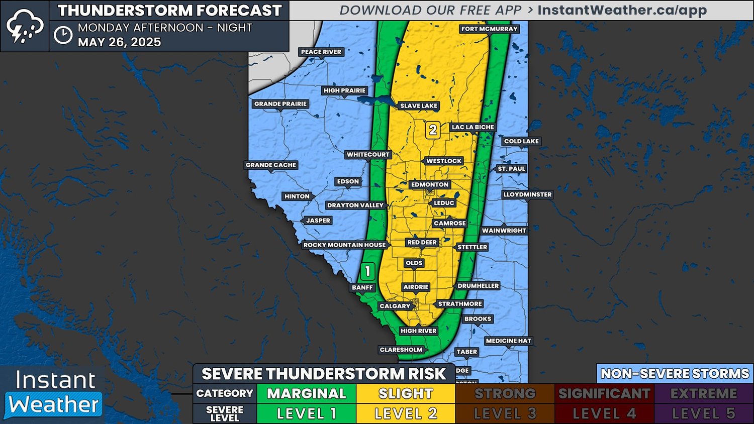
Slight Risk for Severe Thunderstorms on Monday as a Cold Front Advances Through Alberta

Last Updated: April 3, 2025 - 6:24 AM

NOTE: YOU CAN CLICK ON THE MAP TO OPEN A ZOOMABLE IMAGE

The past week was fairly quiet, as far as active weather is concerned, with the odd pop-up thunderstorm surpassing the severe threshold and a couple of funnel cloud reports. This week, however, is slated to start off with a bang as a cold front will move into Alberta later this afternoon, stretching the length of the province and triggering the development of thunderstorms over a widespread area.

We’ve already seen some scattered showers across parts of Central and Northern Alberta today, but the severe threat won’t begin until this afternoon, around 2-4pm. These will be fast-moving storms that will quickly develop and organize into a north-south line along the cold front as it crosses the province through the afternoon and evening. Storm activity will rapidly diminish as we get later into the evening, but isolated storms could continue until closer to midnight, if conditions remain favourable.

The greatest thunderstorm risk will stretch from Calgary northward up to Fort McMurray, highlighted in yellow on our map. This large region could see damaging wind gusts of up to 100km/h and large nickel to quarter-sized hail, along with torrential downpours. At this point, the threat of a tornado appears to be unlikely, but it can not be completely ruled out.

Fire danger map for may 26th produced by the government of Alberta

The amount of lightning associated with today’s storms could also be a concern. Warmer temperatures and drier conditions have elevated the wildfire risk over the past week and has led to High to Extreme Wildfire Danger across the entire province. Significant amounts of lightning, despite the presence of precipitation, could easily spark additional fires given these conditions.

On This Day: The Port Huron/Sarnia F4 Tornado of 1953

The front page of the times herald from Port Huron, Michigan from Saturday, May 23rd, 1953.

Michigan, USA

Monday, May 18th, 1953 – A squall line from the north brought cold, damp weather to Oakland County, MI, for over three days. Three days later, on Thursday, May 21st, 1953, severe thunderstorms developed, pushing cold air eastward across Michigan, while a warm front from the south advanced, delivering humid temperatures to St. Clair County. The protracted battle between cooler temperatures and warm, moist air from the south reached its climax over Smiths Creek, Michigan at 3:30pm.

the location of Smiths Creek, Michigan

By 4:21pm, local radio stations were receiving reports from the Yale area of severe weather conditions, including heavy winds, rain mixed with hail, and darkening skies. As the winds strengthened to 40MPH, a funnel cloud 200 yards wide began to form. At the WTTH Radio Broadcast Centre in Michigan, host Robin Busse issued an urgent warning to residents, notifying them of a tornado touchdown in Smiths Creek, Michigan and advising them to seek shelter immediately in their basements. Before the signal was lost, Robin Busse made a final plea, exclaiming “OH MY… I’VE NEVER SEEN ANYTHING LIKE THIS! PLEASE SEEK SHELTER! HEAD TO YOUR BASEMENTS!” as the wind howled in the background.

The tornado that struck Smiths Creek, Michigan, then entered Port Huron, Michigan, crossing a Lumber Yard on Military Street, and toppling railroad cars along its path before crossing over the St. Clair River. Ralph Polovich, who was a Times Herald Photographer pulled over on Water Street in Port Huron, Michigan to snap a picture of a ‘’White Water Spout’’ as it crossed the river into Sarnia.

Sarnia, Ontario

May 21st, 1953 started off as any other day; a toasty 29 degrees Celsius at 10:24am. By 12:45pm, the temperature rose to 31 degrees Celsius and up to 35 degrees Celsius by 4:25pm. The thunderstorm that led to the tornado dumped golf ball/baseball-sized hail on Sarnia – the hail, which is credited towards saving lives, cleared the streets of motorists and pedestrians as shelter had been found before the tornado struck.

Another radio station (CHOK), located downtown at 148 Front Street North, was broadcasting music and weather updates to the residents of Sarnia. Karl Monk, who served as the stations manager, started his shift at 4pm. ‘’We got some pretty wild weather coming from the West; raining like cats and dogs’’. “Ladies and gentlemen, I just received a note that a tornado has touched down just west of Port Huron. This storm is tracking eastward towards the St. Clair River and has the capabilities to generate a tornado in the Sarnia Lambton Area’’ he announced.

By 5:45pm the tornado hit South of Sarnia Harbor, where it grew in size to 980 yards wide. Moving to the northeast, the tornado hit the downtown area directly, damaging nearly 100 commercial buildings along Front Street and Christina Street.

The Imperial Theatre’s renowned auditorium in Sarnia, suffered a catastrophic collapse. At least 150 homes were damaged, and prior to exiting Sarnia, the tornado veered northeast an began to dissipate as its path narrowed to just 33 yards in width. CHOK maintained continuous coverage throughout the storm, earning recognition for its tireless warnings to Port Huron and Sarnia residents regarding the impending tornado. Much like Robin Busse, Karl Monk was subsequently credited with saving lives through his timely warnings to the public.

the View through the collapsed dome of the Imperial Theatre, Courtesy of the Sarnia Historical Society.

Interesting Facts:

  • Most residents initially believed that an explosion had occurred at the Imperial Oil Refinery in Sarnia. Unbeknownst to them, this was the sound of the actual tornado on the ground.

  • The tornado was believed to have been on the ground for almost 2.5 hours.

  • When the tornado hit, it caused damages exceeding 17 million dollars, left 500 homeless, and made both countries make changes to the way storm warnings were handled.

  • Many survivors reported severe damage to their homes, while houses across the street remained unscathed.

  • The acting Mayor of Sarnia read that the Riot Act would be issued at 11pm that night, which forbade people from going downtown to check out the damage to the area. The area was littered with hazards such as debris, mangled power lines, dead birds and animals, etc. It gave permission for the military to take charge, sending in military personnel from the Ipperwash area, and even calling in the RCMP in to help residents clean up. The National Guard was also called into protect abandoned properties in Port Huron.

  • Just 3 weeks later, on June 8th, an F5 tornado hit Flint, Michigan at about 8:30pm, touching down by a drive-in theatre and killing 116 residents. Coincidentally, on this day, a dinner was being hosted in Michigan honouring Robin Busse from WTTH for his heroic broadcast just 3 weeks earlier.

  • Mail from Flint was found in the debris in Sarnia days after the tornado struck.

damage on Brock Street, Courtesy of the Sarnia Historical Society.

One of our Moderators at Instant Weather, Miranda, lives in Sarnia. Her mom was 5 years old and living in Sarnia when the tornado hit. When Miranda asked her mom to describe what it was like, this is what she said:

“My mother, my sister, and myself lived on the corner of Maxwell and Indian Road, 926 Maxwell to be exact. Our house was a small bungalow, with no basement and no place to seek shelter. My mom was outside on a ladder at the time, tending to the property, when she heard the radio broadcaster telling Sarnia to ‘’Seek shelter immediately’’. She yelled for my sister and I, who were playing outside, to get inside right away.

I recall the sky transforming into a greenish-yellow hue, sirens blaring, and the wind beginning to pick up. The heat that had been intense all day, suddenly was met by a drastic drop in temperature. Hail started to fall, roughly the size of a tennis ball. I never seen the tornado, but I did hear what sounded like a train coming in the distance. The tornado did some damage to surrounding properties nearby, our house was spared thankfully.

Later that evening, my mom, sister and myself walked downtown to Christina Street and Front Street to see the devastation first-hand. I remember dead birds everywhere, along with the old cars flipped upside down on the roadways. We lost a lot of trees in Sarnia on this day. It was incredibly scary; I can remember it like it was yesterday.”

A look at the back of Taylor’s Furniture Store on Christina Street, Courtesy of the Sarnia Historical Society.


Further Reading:

https://sarnianewstoday.ca/sarnia/news/2023/05/19/deadly-storm-sarnia-marks-70th-anniversary

https://skyrisecities.com/news/2016/07/cityscape-how-1950s-tornado-kickstarted-urban-renewal-imperial-city.21782

https://www.flickr.com/photos/sarniahistoricalsociety/albums/72157666099572743/

https://www.newspapers.com/article/the-times-herald-1953-tornado/63629417/

https://www.thesarniajournal.ca/top-story/from-the-archives-city-hall-operator-called-in-militia-after-downtown-devastated-by-1953-tornado-7973120

Ontario’s First Confirmed Tornado of 2025: EF0 Touches Down Near Woodstock Last Week

NOTE: YOU CAN CLICK ON THE MAP TO OPEN A ZOOMABLE IMAGE

Ontario’s tornado season has officially begun. The first confirmed tornado of 2025 touched down during the early morning hours of May 16th, just south of Lakeside, Ontario, northwest of Woodstock.

The tornado developed along the leading edge of a line of storms that had tracked into the province from Michigan.

While this EF0 tornado near Lakeside was the first confirmed in Ontario this year, it wasn’t the first in Canada.

According to the Northern Tornadoes Project, this brings Canada’s confirmed tornado count for 2025 to five.

The season began with an EF0 tornado in Alberta in early April, followed by an EF1 in Quebec later that month. Just one day before the Lakeside event, two EF0 tornadoes were confirmed in Manitoba on May 15th.

With peak season still ahead, this serves as a timely reminder that severe weather can happen quickly and under conditions that don’t always look extreme on the surface.

Even low-end risks deserve attention, especially when storms arrive at night, when people are less likely to be tuned in.


The Tornado: A Narrow but Confirmed Touchdown Near Lakeside

Survey map for the Lakeside EF0 tornado (source: Northern Tornadoes Project)

According to the Northern Tornadoes Project (NTP), the tornado developed just south of the village of Lakeside, approximately 25 km northwest of Woodstock. It touched down around 3:00 AM EDT, shortly after a squall line of thunderstorms entered the region from the west.

Drone photo of worst damage point featuring multiple snapped conifers (source: Northern Tornadoes Project)

Damage was limited to trees and a power pole, with no injuries reported. The tornado was assessed as an EF0, with estimated maximum wind speeds of 115 km/h. It travelled a distance of 3.6 km, with a maximum path width of 160 metres, moving generally from the west-southwest (255°).

Radar data shows possible rotation near lakeside (source: iw pro)

Radar imagery at the time showed a compact area of low-level rotation, but due to the storm’s embedded structure and the overnight timing, the event went unwitnessed until damage was reported later that day.

The NTP conducted both ground and drone surveys on May 20th to confirm the tornado’s track and intensity.

This information is sourced from the Northern Tornadoes Project’s full report, which can be found here.

Survey map showing the location of the EF0 downburst (black oval) and collected data (source: Northern Tornadoes Project)

In addition to the confirmed tornado near Lakeside, the Northern Tornadoes Project also verified a separate EF0 downburst near Chatham from the same storm system.

The downburst occurred around 2:15 AM EDT, roughly 45 minutes before the tornado, and caused significant damage to several barns, farm buildings, power poles, and trees.

While similar wind damage was reported across parts of Southwestern Ontario—from Windsor to Shrewsbury—only the enhanced damage south of Chatham was surveyed.

Wind speeds were estimated to have peaked at 130 km/h, placing the event at the high end of the EF0 scale. No injuries were reported.


Timeline: Forecast Leading Up to the Tornado

Forecast models began flagging the potential for severe storms several days in advance, particularly in Deep Southwestern Ontario, where the environment appeared favourable for severe weather.

Instant Weather and the U.S. Storm Prediction Center both noted the possibility of tornadoes — albeit marginal — due to the timing and nocturnal nature of the storms. This provided over 24 hours of advance notice about the potential for severe weather.

Despite the lower-end risk, one storm managed to spin up a brief EF0 tornado shortly after 3:00 AM on May 16th.


Instant Weather first highlighted the tornado potential on Wednesday afternoon, referencing the Storm Prediction Center’s forecast and the setup in Michigan and Southwestern Ontario:

The following morning, just under 24 hours before the confirmed tornado, Instant Weather once again flagged the risk.

This time, the post specifically mentioned that a 2% tornado risk extended into Sarnia, Chatham, Grand Bend, and as far northeast as London, placing the affected area firmly within the broader risk zone:

Later Thursday afternoon, a forecast was issued by Instant Weather calling for the potential of isolated tornadoes overnight. The forecast map outlined a marginal risk that included the area near Lakeside, where the tornado would eventually touch down:

Around 1:47 AM, just over an hour before the tornado touched down, Instant Weather sent out a custom notification for the London area, referencing minor rotation and clearly stating that “an isolated tornado cannot be ruled out”:

At 2:55 AM, Environment Canada issued a Severe Thunderstorm Warning, which included a note that severe thunderstorms can produce tornadoes. This came approximately five minutes before the tornado would touch down near Lakeside

Finally, live coverage was underway on Instant Weather’s YouTube channel during the time the tornado developed around 3:00 AM, as the storm moved through Oxford County.

Nocturnal Thunderstorm Threat With Damaging Wind Gusts and Isolated Tornado Risk for Southwestern Ontario Tonight

updated map - 10:50 PM (CLICK HERE FOR THE PREVIOUS MAP)

NOTE: YOU CAN CLICK ON THE MAP TO OPEN A ZOOMABLE IMAGE

UPDATE (10:50 PM):

We’ve been closely tracking the line of storms developing across Michigan, and it’s now set to move into Deep Southwestern Ontario over the next few hours.

Based on the latest model data, current environmental conditions, and how well the storm is holding together despite the lack of daylight heating, we believe there’s enough evidence to upgrade parts of Deep Southwestern Ontario to a ‘strong’ (3/5) risk—mainly due to the potential for intense wind gusts.

Large hail up to the size of toonies is also possible, and we can’t completely rule out an isolated tornado.

We’ve also extended the ‘slight’ (2/5) risk further inland to include areas like Goderich and London, as new data suggests the line could stay fairly strong as it tracks deeper into Southwestern Ontario during the pre-dawn hours. Again, damaging wind gusts remain the primary threat.

The line is expected to cross the border just after midnight, with the severe threat gradually tapering off but still continuing until around 3–4 AM.


ORIGINAL FORECAST

While storm season has had a quiet start in Southern Ontario, things are beginning to ramp up with a late-night storm risk expected between Thursday evening and early Friday morning. A strong line of storms is forecast to form across Michigan late tonight, initially beginning as discrete supercells over parts of Wisconsin and Illinois.

Based on the latest guidance, these storms are expected to organize into a more linear structure as they track eastward, eventually crossing into Southwestern Ontario sometime just after midnight. While they’ll likely lose some of their strength after dark, especially without daytime heating, the atmosphere may still be supportive enough for them to maintain some intensity as they move into our region.

That said, there’s still a fair amount of uncertainty about just how strong this line will be once it crosses the border, and how quickly it might weaken as it tracks northeast through the early morning hours of Friday.

The biggest concern with this system is the potential for damaging wind gusts. This squall line will stretch from the Upper Peninsula of Michigan all the way down through Ohio as it enters Ontario, which could lead to widespread impacts. Areas from the Bruce Peninsula all the way down to Deep Southwestern Ontario are at risk of strong winds embedded within the line.

The highest risk appears to be in Deep Southwestern Ontario, where the line will first cross into Ontario. Regions like Windsor, Leamington, Chatham, and Sarnia are most likely to experience the strongest part of this line. While damaging wind gusts are the main hazard, we also can’t completely rule out the chance for hail and even a brief tornado, especially if the storms arrive a bit earlier than forecast.

Hail up to the size of quarters is possible, and while the tornado risk is considered low overall, it does exist. The biggest concern here is that this is a nocturnal threat. If a tornado were to develop overnight, it would be harder to spot and could be rain-wrapped, making it even more dangerous. That’s why it’s so important to stay alert and have a way to receive warnings while you sleep.

SIMULATED RADAR - MAP FROM WEATHERBELL

Storm development will begin with discrete cells over Wisconsin and Illinois, likely forming into a long line around 8–10 PM near Chicago and across Lake Michigan.

The timing of this formation is crucial. If the line develops sooner and sweeps across Michigan quickly, it could result in a more robust severe risk for Deep Southwestern Ontario, where the environment is more favourable before midnight.

No matter the timing, damaging winds remain the most likely outcome with this type of linear storm setup.

SIMULATED RADAR - MAP FROM WEATHERBELL

As of now, future radar models suggest the storms will cross into Ontario between 1 and 2 AM, hitting areas like Windsor and Sarnia first before stretching further northeast. However, there’s still wiggle room in this timing. It could arrive earlier and stronger, or later and already weakening before reaching our region.

ESTIMATED TORNADO ENVIRONMENT - MAP FROM WEATHERBELL

While widespread wind damage is the primary concern tonight, there is some minor tornado potential—especially in Essex County just after midnight. Again, the odds are low, but not zero.

Because of the overnight timing, it's extra important to have notifications enabled on your phone or weather radio. Make sure you have a way to receive alerts while you're asleep in case a warning is issued. Our free app is a great way to instantly get Environment Canada alerts, along with our custom notifications issued for your exact location.

SIMULATED RADAR - MAP FROM WEATHERBELL

The line of storms is expected to continue northeast through the early morning hours, bringing heavy rain, gusty winds, and frequent lightning to much of Southwestern Ontario and parts of the Greater Toronto Area between 3 and 6 AM.

While the line should gradually weaken during this time, it could still pack a punch in some localized areas. There’s some uncertainty around how long it will be able to hold its strength since the atmospheric environment in Ontario is notably weaker than what the storms had access to in the U.S.

Latest model runs show the system likely fizzles out once it reaches Lake Simcoe, meaning Eastern and Central Ontario probably won’t see much beyond a few scattered morning showers or storms.

Another round of storms is possible Friday afternoon and evening, particularly for Eastern Ontario and parts of Deep Southwestern Ontario. We’ll have more details on that in a separate update.

As it stands, the highest storm risk tonight is in Deep Southwestern Ontario, where we currently have a slight risk (2/5) for severe weather. The main hazard is damaging wind gusts between 12 and 6 AM, though isolated tornadoes and hail up to the size of quarters are also possible.

For the rest of Southwestern Ontario and the Golden Horseshoe, the risk is lower—a marginal (1/5) severe threat—with isolated pockets of wind damage being the most likely outcome. There’s also a very low tornado risk along the Lake Huron shoreline as the line initially pushes into the region. Hail up to the size of nickels could accompany some of these storms.

In addition to the overnight threat, a few isolated pop-up storms are possible during the late afternoon and early evening across parts of Grey-Bruce. While these are not expected to be severe, funnel clouds are possible, including a low-end risk of a landspout tornado. See our custom notification for more on the funnel cloud setup.

Stay weather-aware tonight. Keep your devices charged, notifications turned on, and have a plan in place just in case you need to take shelter quickly. We’ll continue to monitor the latest data and provide updates as the situation evolves, including a possible live stream later tonight.

Up to 75mm of Rain for Parts of Southern Saskatchewan & Manitoba, Along with Worsening Air Quality, Expected to End the Work Week

NOTE: YOU CAN CLICK ON THE MAP TO OPEN A ZOOMABLE IMAGE

It is certainly shaping up to be a roller coaster of a week, weather-wise, across Saskatchewan and Manitoba. The week began with record-breaking heat and relentless winds, which made things feel exceptionally dry and were the catalyst for the spread of multiple wildfires across both provinces. Now, cool Arctic air has flooded south and a low pressure system is pushing its way northward from the Dakotas, which will bring significant rain to parts of Southern Saskatchewan and Manitoba on Thursday and Friday.

Pockets of rain on the leading edge of this system have been pushing northward into Southeast Saskatchewan and Westman already Wednesday evening. This will be followed by a large area of steady, heavier rain moving into this region shortly after midnight and continuing through most of the day Thursday.

The rain will gradually spread further northward Thursday morning and by the afternoon, it should also start to cross the border into the rest of Southern Manitoba. This delay in the start of the precipitation will lead to slightly less rain falling overall, but it’ll be fairly steady for the remainder of the event so a widespread 25-50mm can be expected.

In Southeast Saskatchewan and Westman, the earlier start to the precipitation will lead to this area receiving upwards of 75mm of rain. Considering this region already received a fair bit of rain Wednesday morning, this much additional rainfall could very easily lead to some localized flooding.

The center of this system will stay south of the border and will start making its way eastward early Friday morning. The rain will start to taper off, from west to east, beginning Friday morning, before it completely exits the region Saturday morning.

As far as the wildfire situation is concerned, this rain will definitely help containment and suppression efforts in some areas, but it likely won’t be enough to completely douse the flames. In Southeast Manitoba, where several out-of-control fires are burning as of Wednesday evening, 10-25mm is expected to fall with this system, which will be welcomed support.

In Saskatchewan though, the rain will unfortunately not push deep enough into the province to impact the fires that have been burning near Narrow Hills Provincial Park, to the north of Nipawin, so hopefully the cooler temperatures will be enough to help crews in this area.

The arrival of this low pressure system will also have a negative impact, mostly in Southern Manitoba, but also in Western Saskatchewan. As the low approaches, the wind direction will shift, causing wildfire smoke to start moving westward in Manitoba and southward through Saskatchewan.

But why does this happen? To explain, we need to dig a bit deeper into the science of meteorology.

Modelled low-level Wildfire Smoke Concentration at 12pm CT on Thursday, May 15th. Note: this particular model only extends so far into Canada, but it shows the movement of smoke in both Manitoba and Saskatchewan.

One of the fundamental rules in meteorology is that air will always want to flow from areas of high pressure to areas of low pressure. This is actually the main driver behind wind.

Air doesn’t take a straight path from high pressure to low pressure, though. Thanks to the Coriolis Effect, caused by the spinning of the planet, air travels towards a low pressure center in a more counter-clockwise fashion, as shown below.

diagram showing how air moves around both high pressure and low pressure centers, courtesy of NOAA.

Putting this all together, as the low pressure center gets closer to us, air will naturally travel towards it and this will pull the wildfire smoke along with it. With where the low will be positioned over North Dakota, this means that smoke will travel westward from the fires burning in Southeast Manitoba and Northwestern Ontario and southward from the fires in Northern Saskatchewan.

This is expected to begin early Thursday morning in Manitoba and after sunrise in Saskatchewan, continuing through the day. On Friday morning, as the low pressure center begins its trek eastward, the wind will start to shift direction. This will be much more noticeable in Manitoba, being closer to the low, with the smoke travelling southwestard during Friday morning and then southward by the afternoon.

Given the number of nearby active fires and their sizes, especially the Nopiming Fire, there is already more smoke in the air in Southern Manitoba than in Northern Saskatchewan. This means that greater concentrations of smoke will move into Winnipeg and the Interlake Region on Thursday and it will diffuse along its path southwestward as it curves towards the low. Then, as the winds shift direction, the thickest smoke will still be found closest to the fires and becoming more diffuse the further away.

In Saskatchewan, the smoke from the two fires near Narrow Hills Provincial Park will travel south-southwestward, into Prince Albert and Saskatoon. Given the distance from the low pressure center, the wind shift is expected to be minimal on Friday.

If the wildfire smoke moves into your area, especially at higher concentrations, try to limit your time spent outside, if possible. We certainly hope that with the arrival of the cooler air and the rain in some areas, that firefighter crews will be able to make considerable progress battling these fires and we will soon have some reprieve from the smoke.

Last Day of Heat Wave for Most of Southern Manitoba on Tuesday Ahead of Major Cool Down

NOTE: YOU CAN CLICK ON THE MAP TO OPEN A ZOOMABLE IMAGE

We have one final day of extreme heat ahead for most of us in Southern Manitoba on Tuesday as once again, temperatures are expected to climb as high as 37°C.

There is some relief on the way for the region, though, with cool air expected to start pushing southward Tuesday evening and bringing single digit overnight low temperatures to almost the entire province. This might not be quite enough to cancel the Extreme Heat Warning for all of Southeast Manitoba. This area could still see temperatures in the low 30s on Wednesday, particularly around Steinbach and eastward.

This cool down will bring single digit high temperatures back to much of Southern Manitoba later in the week and overnight Friday, temperatures could even dip below the freezing mark. With a low pressure system developing over the region to end the week, we could even see the return of some mixed precipitation with these subzero temperatures. It will definitely be a case of weather whiplash this week!

Modelled Temperatures (in °C) at 4AM ct on Saturday

First Slight Severe Thunderstorm Risk of the Year for the Prairies Monday Afternoon Through Tuesday Morning

NOTE: YOU CAN CLICK ON THE MAP TO OPEN A ZOOMABLE IMAGE

While we saw some severe storms eventually develop in Southeast Saskatchewan and Southwest Manitoba yesterday, the severe threat for today and into the overnight hours is heightened, resulting in our first Slight Risk of the season.

We’ve already seen heavy rain falling in parts of Central and Southern Alberta today, but thunderstorms have begun to develop and will continue as we progress later through the afternoon and into the evening At this point, it’s possible that these storms may become severe, with the main threat being strong wind gusts and heavy rain. The environment today is also conducive for the development of landspout (non-supercell) tornadoes around Calgary and to the east of the city so we will be watching this situation closely.

It’s further east, in Southern and Central Saskatchewan and Manitoba, that we’re seeing the greatest severe thunderstorm threat. Isolated storms are expected to start developing in the early evening, around 5-6pm and possibly a bit sooner in the afternoon, and models are once again suggesting that the environment could be favourable for the development of supercells.

A bit later in the evening, closer to 7-8pm, we could see some additional storm development in Southwest Saskatchewan as a multicellular line. This complex of storms would travel northeastward across the province and move into Central Manitoba in the early morning hours of Tuesday. It’s during these early morning hours that we could also see more isolated storms develop in Southwest Manitoba.

Large hail, damaging winds, and torrential downpours are all concerns with today’s storms. The possibility of tornadoes is low, but the development of one or two can not be completely ruled out.

Second Day of Temperatures Above 30°C Will Continue to Bake Southern Saskatchewan & Manitoba

NOTE: YOU CAN CLICK ON THE MAP TO OPEN A ZOOMABLE IMAGE

Monday will mark the second day of our heatwave in Southern Saskatchewan and Manitoba. We will once again have a large area expecting temperatures above 30°C, and above 35°C temperatures are possible in a small pocket of Southern Manitoba that includes Winnipeg. Extreme Heat Warnings remain in place from Environment Canada for parts of Southern Manitoba for daytime highs up to the mid 30s and overnight lows only dropping down to the mid teens.

With extreme heat, it’s important to limit strenuous outdoor activities, if possible, or take multiple breaks and drink water often to protect yourself from heat exhaustion and stroke. Early signs of heat exhaustion include: headache, nausea, dizziness, thirst, dark urine and intense fatigue. In the presence of these symptoms, stop all activities and hydrate. Heat stroke, on the other hand, is much more serious. Heat stroke is most identified by confusion and loss of consciousness so make sure to seek immediate medical condition if someone is showing these symptoms.

Marginal Risk for Thunderstorms in Southern Saskatchewan and Manitoba Beginning Sunday Evening

NOTE: YOU CAN CLICK ON THE MAP TO OPEN A ZOOMABLE IMAGE

With the arrival of the first heat wave of the year to Southern Saskatchewan and Manitoba this weekend, we’re also looking at our first real threat of severe thunderstorms for the season.

Isolated storms are expected to develop along the American border in both Saskatchewan and Manitoba this evening, starting around 5-7pm. The storms will travel northeastward into both provinces throughout the evening and into the overnight hours.

Models are suggesting that the environment could be favourable for the development of supercells, but further analysis puts the development of severe storms in question and storms could remain sub-severe. One particular area of interest for possible severe storm development will be in Southeastern Saskatchewan and through the Westman and Interlake Regions.

If severe storms end up developing this evening, the overall threats are expected to be limited. These storms could produce small hail and strong wind gusts, while the possibility of a tornado is unlikely.

First Heat Wave of the Season Will Bring Three Days of Record Breaking Temperatures to Southern Manitoba

NOTE: YOU CAN CLICK ON THE MAP TO OPEN A ZOOMABLE IMAGE

There is a low has that been passing through the Prairies over the past couple of days, which will cross into Manitoba overnight Saturday. It will set up over the region for several days, drawing in hot air from the south. This will lead to an extended period with daytime highs in in the low to mid 30s and overnight lows in the mid teens, triggering Extreme Heat Warnings already being issued by Environment Canada.

With extreme heat, it’s important to limit strenuous outdoor activities, if possible, or take multiple breaks and drink water often to protect yourself from heat exhaustion and stroke. Early signs of heat exhaustion include: headache, nausea, dizziness, thirst, dark urine and intense fatigue. In the presence of these symptoms, stop all activities and hydrate. Heat stroke, on the other hand, is much more serious. Heat stroke is most identified by confusion and loss of consciousness so make sure to seek immediate medical condition if someone is showing these symptoms.

First Strong Severe Thunderstorm Risk of the Season in Southern Ontario on Tuesday With Tornadoes Possible

NOTE: YOU CAN CLICK ON THE MAP TO OPEN A ZOOMABLE IMAGE

After a gruelling winter filled with relentless snow squalls, powerful winter storms, and a major ice storm to top it all off, we are finally shifting gears into more typical spring and summer-like weather across Southern Ontario. But with the warmer air comes the return of severe thunderstorms, something Southwestern Ontario has already gotten a small taste of over the past few weeks.

We have been closely tracking the potential for our first strong severe weather threat of the season on Tuesday. Model guidance has been consistently highlighting the potential for a very active environment, one capable of supporting tornadoes, large hail, and damaging wind gusts. That risk still looks to be on track, although there remains some disagreement between models on exactly where the strongest environment will set up.

At this time, we believe the strongest severe weather risk will focus across parts of Southwestern Ontario, Central Ontario, and into Eastern Ontario. Other areas across Southern Ontario will still carry a marginal to slight risk, meaning a few severe storms could pop up, but the widespread threat will be lower outside the main zone.

Tuesday’s possible storm threats include one or two tornadoes, large hail — potentially up to the size of toonies or even timbits — widespread damaging wind gusts over 90-100 km/h, and heavy rainfall that could cause localized flooding in some spots.

The storm risk will kick off early Tuesday morning as an area of convection moves across the region between 6:00 a.m. and 12:00 p.m. Most of these morning storms should remain non-severe, but we can't rule out a rogue severe cell, especially in setups like this. Where these morning storms track and how quickly they clear out will be important to watch, as leftover clouds or rain could limit how unstable the atmosphere becomes later in the day.

By the early afternoon hours, the environment is expected to rapidly become more favorable for severe weather. Areas along the Lake Huron shoreline will likely be the first to feel the effects, with the risk then spreading into parts of Central Ontario.

Even though we are confident that the setup is capable of producing severe storms, it’s important to stress that storms actually have to form to take advantage of the environment. Not everyone in the higher-risk zone will necessarily see a storm. These will be isolated events, meaning only a small percentage of the region will be directly impacted.

The highest tornado risk will likely occur earlier in the day across Southwestern and Central Ontario, when individual storms (known as discrete supercells) can remain separated and feed off the prime environment around them.

As the afternoon progresses and storms track further eastward, we expect that they will start to merge into more of a line, which would shift the threat more towards damaging winds and heavy rain rather than tornadoes and large hail.

By late afternoon into early evening, the severe weather risk will push eastward into the Golden Horseshoe and Eastern Ontario. The good news is that the risk should wind down quickly after sunset, which occurs around 8:00 p.m.

There could still be some leftover showers or weak storms lingering into the evening, especially across Eastern Ontario, but the threat for damaging weather will rapidly diminish once the sun goes down.

We’ll continue to monitor this setup closely and provide updates as new data becomes available. Stay tuned, and as always, make sure you have a way to receive alerts if storms develop in your area.

Download our free app to instantly get any Environment Canada alerts and our own custom notifications pushed to your phone. We are planning to go live to cover any storms that develop throughout the day on Tuesday. Please subscribe to our YouTube channel here so you can be notified when we go live.

REGIONAL BREAKDOWN

🌪️ ‘Tornado Tuesday’: Confidence Continues to Build For Significant Severe Thunderstorms Next Week in Ontario ⛈️

NOTE: YOU CAN CLICK ON THE MAP TO OPEN A ZOOMABLE IMAGE

TUESDAY, APRIL 29, 2025: Confidence continues to build for the risk of significant severe thunderstorms and tornado activity this Tuesday. Since our first article posted on Friday morning where we discussed this potential, we’ve continued to carefully monitor a strengthening trend on the forecast models. And at this point, we’re trending up from what initially looked like an Enhanced Risk (3/5), towards an isolated Significant Risk (4/5) based on the latest data. What we’re expecting at this point is isolated strong-to-significant severe thunderstorms across parts of Southwestern and Central Ontario Tuesday afternoon & evening that could possibly extend into the GTHA and parts of Eastern Ontario overnight, depending on the timing and speed of the cold front.

A lot can still change four days out but the consistency of the model data is why we here at InstantWeather have been discussing this for several days and why even Environment Canada has issued a preliminary forecast map today, discussing some of the risks on Tuesday including 100km/h damaging wind gusts and 2-4cm hail as you can see in the image below.

NOTE: YOU CAN CLICK ON THE MAP TO OPEN A ZOOMABLE IMAGE

Environment Canada, in their first forecast map for this event has not mentioned a tornado risk. This is likely because we’re four days out but based on the data that we’ll be reviewing below, we’d be very surprised if they did not add a tornado risk in their forecast update tomorrow. Along with this forecast map, they wrote:

”A cold front will track east across northeastern and southern Ontario. By the afternoon, severe thunderstorms may develop with the main threats being strong wind gusts and large hail.”


🔎Model Data Review

NOTE: YOU CAN CLICK ON THE MAP TO OPEN A ZOOMABLE IMAGE

In the image above, we’re looking at the latest “NAM” model data for 5pm on Tuesday and what we’re reviewing is the “Supercell Index”. This gives us an idea of how potent the environment is for rotating storms, which can lead to damaging wind gusts, large hail, flooding, intense lightning and in some cases, tornadoes. In our previous article, we only saw an orange supercell risk which is roughly an “Enhanced” risk level (3/5). However, in the latest data we are now seeing the colour red, which is hinting at the potential for a “Significant” risk level (4/5).

And in the image below, we see what the “Supercell Index” looks like at 8pm from the same “NAM” model, continuing the strong environment into the evening hours and extending it further into Eastern Ontario.


NOTE: YOU CAN CLICK ON THE MAP TO OPEN A ZOOMABLE IMAGE

It’s still quite early but we’re now finally getting some higher quality data from the NAM model at 12km resolution and what you’re seeing above is simulated or “Future Radar” of how the event might play out. It’s still quite early and this could certainly change but it’s interesting to watch it evolve day-by-day. With this model run, the storms start to develop on the Lake Huron shoreline near the Kincardine and Goderich areas around 5pm. We do see some development up by Britt as well around that time. Again, this is just estimated and we could see a new solution to how this plays out each and every day leading up to Tuesday.


NOTE: YOU CAN CLICK ON THE MAP TO OPEN A ZOOMABLE IMAGE

By 8pm in the image above, the simulated NAM future radar is suggesting we could see several potent supercells tracking through parts of Southwestern and Central Ontario. In previous model runs, we have seen a large line of storms as well, which in some cases can limit the tornado risk. Although, we could end up dealing with multi-cell supercells with an environment this strong and those can most certainly produce strong, isolated tornadoes.


NOTE: YOU CAN CLICK ON THE MAP TO OPEN A ZOOMABLE IMAGE

And in this potential scenario from the NAM model, we still the storms expanding and tracking through deep Southwestern Ontario, Central Ontario and perhaps into parts of Eastern Ontario by 11pm. Typically, the later in the evening we get, the less we daytime heating we have to increase the severity of these storms but with how strong this environment is, it could be a late night for many of us and we’ll certainly be livestreaming as long as it takes to ensure everyone stays informed and safe.

If you’d like to get notified when we start livestreaming, subscribe to our YouTube channel for free and hit the bell icon to get notified when we go live.

And to get notified of any rotation detected, funnel cloud reports, tornado reports and Environment Canada watches & warnings, download our free mobile app InstantWeather on your phone or tablet.


🤔Final Thoughts:

If this trend continues and this system does not decide to weaken all of the sudden (here’s hoping it does), Tuesday continues to look like a strong or potentially significant severe thunderstorm risk. All modes of severe weather could be on the table with damaging wind gusts, torrential rain, isolated flooding, large hail, intense lightning and the potential for isolated tornadoes, some of which could be strong. Here’s hoping that it weakens into a marginal risk or vanishes all together!

Having said that, please begin to review your storm safety plan and start discussing the potential for rescheduling your Tuesday afternoon/evening plans.

More details ASAP.


Disclaimer: By using our services and any associated content, this means you implicitly agree to use the services and data available as is with no warranty issued or implied and should be used for informational purposes only. Any use of this data for decision making processes is done at the sole risk of the end user. Do not reproduce or disseminate our forecasts and content without explicit consent of Instant Weather, Inc.

Soggy Last Weekend of April Will Bring Over 50mm of Rain to Parts of the Maritimes

NOTE: YOU CAN CLICK ON THE MAP TO OPEN A ZOOMABLE IMAGE

As we come close to the end of the month, the April Showers will hit in full force this weekend, with at least 20mm of rain expected across the Maritimes by the end of Monday.

Light rain will start to push into New Brunswick from the west in the early morning hours of Saturday, tracking from southwest to northeast. This will be a brief first round of rain that will cross through New Brunswick and into PEI during the morning. In Northern New Brunswick, the cool air could result in some brief light snow falling during the morning, but we’re not expecting much accumulation and it will melt with rain that will follow.

The Annapolis Valley and Cumberland County could see a bit of rain along the southern edge of this initial band as it crosses the region, however, the majority of the rain will come in the following round.

Model Image showing the location and intensity of snow (Blue) and Rain (Green) at 3AM AT Saturday

Not far behind the initial round, the main band of more widespread rain will make its way into the region beginning late Saturday morning. The rain will be very heavy at times as it crosses through the Maritimes for the remainder of the day and into Sunday afternoon.

In New Brunswick, the rain will be heavy during the afternoon and evening before becoming lighter later in the evening and ending overnight. Prince Edward Island can expect the heavier rain to begin in the evening, which will persist into Sunday morning before it tapers off in the early afternoon.

Nova Scotia will see the heaviest rain for an extended period of time with this system. The rain will intensify in Western Nova Scotia starting early Saturday evening and it will spread eastward across the province throughout the evening. It will continue overnight and for most of Sunday morning. It will start to taper off from west to east in the mid-morning, but some areas, particularly along the Atlantic Coast, can expect to see steady rainfall continue into the evening, leading to over 50mm falling.

Model Image showing the location and intensity of snow (Blue), freezing rain (Pink), and Rain (Green) at 12AM aT Sunday

Mid-Sunday morning will see the return of some scattered showers across New Brunswick, which will reach PEI in the late afternoon and continue into early Monday morning. This final lingering band of light rain will push southeastward into Nova Scotia around sunrise Monday and will gradually dissipate in the afternoon and evening.

The entirety of the Maritimes can expect at least 20mm and a widespread 30-50mm is forecast for the region. In Western Nova Scotia, along the Atlantic Coast and into Cape Breton, the heaviest rain is expected, with periods of downpours, which will result in over 50mm of rain and even up to 75mm. If a downpour happens to settle over a particular area for a longer period, closer to 90mm of rainfall is not out of the question.

Strong wind gusts will accompany the rain, reaching up to 60km/h across much of the region Saturday night and Sunday morning. The winds will be stronger in parts of Nova Scotia, especially along the Atlantic Coast and through the Highlands, where gusts could exceed 70km/h, while gusts up to 100km/h are likely in northwestern Cape Breton.

Hopefully with all this rain and some warmer temperatures to end the month, we’ll see plenty of May Flowers!

🌪️ ‘Tornado Tuesday’ Might Make a Return in Southern Ontario Next Week ⛈️

NOTE: YOU CAN CLICK ON THE MAP TO OPEN A ZOOMABLE IMAGE

TUESDAY, APRIL 29, 2025: As I write this discussion (2am on Friday, April 25th, 2025), we’re quite a few days away from Tuesday, April 29th, 2025. Having said that, I’ve been carefully monitoring this strengthening trend on the forecast models for several days now and seeing them consistently suggesting an enhanced risk (3/5) for severe thunderstorms across much of Southern Ontario with the potential for isolated tornado activity. From Windsor, up through Barrie and perhaps even reaching parts of Eastern Ontario and the GTHA.

Typically, five days out is a lifetime for forecasting severe weather. Having said that, in rare circumstances you can see these strong environments coming from a mile away and this looks like this could be one of those events. Especially when we have a lot of data supporting the risk, which we’ll discuss further down the page.

Could this all change? You betcha. After more than a decade of forecasting severe weather in Ontario and across Canada, I’m no stranger to the potential for a “bust”. I could write this article and the entire system could vanish from the weather models. Tuesday could end up being just another typical spring day. Here’s hoping that’s the case. If, however, that is not the case and the trends we’re seeing in the models are correct, this is the type of event that requires getting the word out well in advance so that alternative plans can be considered and you can review your safety plan with your loved ones.

FRIDAY, APRIL 25, 2025: I should probably mention that we will have a risk for isolated thunderstorms today (Friday) and there is a marginal (low) risk for severe storms in deep southwestern Ontario later this afternoon and into the evening hours. Briefly severe hail and strong wind gusts are possible. At this point, it doesn’t look particularly intense but we’ll be keeping a close eye on it, nonetheless.


🔎Reviewing Models & Available Data For Tuesday

NOTE: YOU CAN CLICK ON THE MAP TO OPEN A ZOOMABLE IMAGE

Typically, we like to compare the data from several different model systems. In this case, we’ll compare the American model, the European model and our own Canadian model. In the image above, we’re looking at the American model and what we’re reviewing is the severe weather “energy” that the storms are going to have available to them. The highest levels reaching almost 2,500 (in yellow/orange), which puts this event in the ‘Enhanced 3/5’ category, in my personal opinion.

For context, we can have marginal severe weather with energy levels as low as 500. And on the high-end, CAPE can reach as high as 5,000+ in the most extreme cases. So we’re somewhere in the middle, with totals potentially reaching greater than 1,000 and less than 3,000, at least, at this point.

NOTE: YOU CAN CLICK ON THE MAP TO OPEN A ZOOMABLE IMAGE

Above is the Euro model, showing similar strong values to the American model in the deep southwest at 2pm. But, as you’ll see below, the energy progresses further east as we approach 5pm on Tuesday.


NOTE: YOU CAN CLICK ON THE MAP TO OPEN A ZOOMABLE IMAGE

Above, we’ve got the 5pm timeframe from the Euro model. Showing organized energy values in place for the expected thunderstorms in the afternoon and evening hours.


NOTE: YOU CAN CLICK ON THE MAP TO OPEN A ZOOMABLE IMAGE

While we’re taking a look at the European model, one interesting product they have is an estimated lightning density over several hours. As you can see in red, orange yellow and blue, quite a lot of thunderstorms are expected throughout the afternoon and into the evening hours, taking advantage of all that storm energy we discussed previously.


Below, let’s take a look at the Canadian energy for Tuesday. For some reason, the data looks really blocky. Not sure why PivotalWeather.com (the model provider we’re using for these images) is processing the Canadian model this way but perhaps, it’s coming that way directly from Environment Canada.

Regardless, a similar trend is showing up on the Canadian model that we’re seeing on both the European and American models. And with that, we have what is considered “model agreement”. And it’s not just these three models, other forecasting products called ‘Ensembles’ have 30+ model members and the vast majority are showing a strong severe thunderstorm risk for Tuesday.


NOTE: YOU CAN CLICK ON THE MAP TO OPEN A ZOOMABLE IMAGE

This Canadian model image above is for 2pm on Tuesday. And similar to the European model data where we showed two separate timestamps (2pm and 5pm), this energy will push east, through the Barrie area and potentially into the GTHA and parts of Eastern Ontario through the afternoon and evening hours. Energy values look similar to the other two models, supporting the potential for an Enhanced Risk of severe thunderstorms.


Some other data worth noting in the image below is from the Storm Prediction Center (SPC) in Norman, Oklahoma. Not surprisingly, they are already showing a risk map for Tuesday, which they typically only show this far out when there is a strong system expected and a lot of agreement within the weather models.

You can see that southwestern Ontario gets highlighted in this risk area from Windsor, through Chatham-Kent and Sarnia, cutting off just shy of London. Having said that, the SPC’s only job is to forecast for the US. And as we’ve seen historically with them over the past decade, if they’re showing an extended range forecast that highlights parts of Southern Ontario, we could be in for quite the storm system much further into the Province than is shown below.

NOTE: YOU CAN CLICK ON THE MAP TO OPEN A ZOOMABLE IMAGE


And in the final image below, we’re looking at a Machine Learning (AI) based severe weather estimation from the US. In this case, they cut off the data at the international border but by simply using your imagination, it’s clear that Southern Ontario is included in this risk region.

NOTE: YOU CAN CLICK ON THE MAP TO OPEN A ZOOMABLE IMAGE


🤔Final Thoughts:

If these trends continue and this system does not decide to vanish from all the models suddenly (here’s hoping it does), Tuesday is shaping up to be a strong or potentially significant severe thunderstorm risk. All modes of severe weather could be on the table with damaging wind gusts, torrential rain, isolated flooding, large hail, intense lightning and the potential for isolated tornadoes, some of which could be strong. Here’s hoping that it weakens into a marginal risk or vanishes all together!

Having said that, now would be a good time to start reviewing your storm safety plan and discussing your plans for Tuesday if this system does decide to show up and affect Southern Ontario.


Disclaimer: By using our services and any associated content, this means you implicitly agree to use the services and data available as is with no warranty issued or implied and should be used for informational purposes only. Any use of this data for decision making processes is done at the sole risk of the end user. Do not reproduce or disseminate our forecasts and content without explicit consent of Instant Weather, Inc.

Post-Easter Storm Could Bring Up to 20cm of Snow to Parts of Saskatchewan and Manitoba

NOTE: YOU CAN CLICK ON THE MAP TO OPEN A ZOOMABLE IMAGE

As we get later into the month of April, there have already been tastes of warm weather across the Prairies, with temperatures climbing into the upper teens and low 20s across parts of all three provinces. Don’t let that fool you because it is still spring in the region and that means the continued possibility of heavy snowfall events. This will be the case beginning Tuesday morning and continuing into Wednesday for parts of Saskatchewan and Manitoba.

Model Image showing the location and intensity of snow (Blue) and Rain (Green) at 5AM cT Tuesday

Steady light snow is expected to continue in West Central Saskatchewan overnight Monday and into Tuesday morning. Early Tuesday morning, a low pressure system will push northward from North Dakota, bringing precipitation to Southeastern Saskatchewan and Southern Manitoba. The two areas of snow will merge before sunrise, creating a wide band of continuous snowfall.

As the morning progresses, the system will stall and the light snow in Western Saskatchewan will taper off. On the other hand, the snowfall will intensify along the Saskatchewan-Manitoba border. Further eastward, into the Central Plains and across to the Ontario border, above-freezing temperatures will result in the precipitation from this system falling as rain.

Model Image showing the location and intensity of snow (Blue) and Rain (Green) at 7pM cT Tuesday

Most of the snow will clear in Saskatchewan through Tuesday afternoon, leaving only the area of heavier snow on both sides of the Manitoba border by the evening. The snowfall will persist over this area overnight and it will gradually dissipate throughout the early morning hours.

In this area of constant snowfall, which includes Melville, Moosomin, and Yorkton in Saskatchewan, as well as Dauphin, Roblin, and Russell in Manitoba, residents can expect up to 20cm of snow accumulation by mid Wednesday morning. Depending on how much intensification we see Tuesday morning, it’s possible that up to 25cm could fall locally.

This much snow over a brief period will definitely make travel tricky throughout the day Tuesday so make sure to take extra caution when out on the roads.

Southern Ontario: School Bus Cancellations and Closures for Tuesday, April 8, 2025

**Please refresh your page every few minutes to receive the latest update**

Cancellation & Closure Map (English Public and Catholic Schools)

Please note: School board boundaries are a rough estimate. Don’t use this map to determine what school board or weather zone you live in as accuracy isn’t guaranteed.

  • Green = No Cancellations

  • Red = Cancellations (Click for More Details)

  • Purple = School Closures (Click for More Details)

List of Cancellations & Closures

English Public and Catholic Schools

  • Near North Public & Nipissing-Parry Sound CathoIic: Bussing for all weather corridors are cancelled today.

  • Renfrew County Public & Renfrew County Catholic: Zone 4 Madawaska area transportation services only are cancelled.


French Schools

  • Le Conseil scolaire public du Nord-Est de l’Ontario (CSPNE) & Conseil scolaire catholique Franco-Nord: Bussing for all weather corridors are cancelled today.

'Snow Day' Forecast: Heavy Snow Likely to Cancel School Buses in Parts of Southern Ontario on Tuesday

For an updated list of school bus cancellations & school closures, please visit our live article: https://instantweatherinc.com/article/2025/4/8/bus-cancellations

NOTE: YOU CAN CLICK ON THE MAP TO OPEN A ZOOMABLE IMAGE

As we move into April, the chances of school bus cancellations continue to shrink with each passing day, especially as we begin to leave winter weather behind. However, winter isn’t done with us just yet. A late-season blast of snow could bring another round of disruptions to parts of Central and Eastern Ontario, with snowfall totals potentially reaching up to 25 cm over the next 24 hours.

The greatest potential for school bus cancellations lies in the northern sections of Central and Eastern Ontario, where snowfall warnings are currently in effect from Environment Canada. Areas most at risk include the Near North region—covering East Parry Sound and North Bay—as well as North Hastings under Tri-Board, and Renfrew County.

In these regions, the chance of a snow day is estimated at over 75%. However, while conditions are certainly favourable, the expected snowfall amounts sit right at the borderline for cancellations, so there isn’t enough confidence to push the probability up to 90%.

In the Ottawa region, even though a snowfall warning is also in place, the area is predominantly urban and has a higher tolerance for winter conditions when it comes to school transportation decisions. Historically, it takes a significant snowfall event to warrant widespread cancellations. Because of this, the probability has been set at a lower 25%.

That said, some weather models are showing the potential for more than 20 cm of snow in the area, and if those more aggressive forecasts come to pass, Ottawa’s snow day risk could increase sharply overnight.

Moving further south and west, the likelihood of school bus cancellations drops noticeably. Snowfall totals in these areas are expected to be much lower and likely won't reach the levels needed to trigger cancellations.

An exception to this could be communities along the Lake Huron shoreline. In these areas, heavier lake-effect snow bands may develop overnight, especially when combined with strong wind gusts, creating blowing snow and reduced visibility. Because of this, we've assigned a slight 25% chance of cancellations in those zones.

Meanwhile, no significant impacts are expected across the Greater Toronto Area (GTA) or Deep Southwestern Ontario. These regions are forecast to receive only a dusting of snow at most, with many areas likely to see little to no accumulation over the next 24 hours. As a result, we aren’t anticipating any school bus cancellations in these parts of the province.


Disclaimer: Instant Weather has zero authority when it comes to bus and school closures.

It is completely up to the school boards, bus companies, local authorities, and parents to decide what is best for their children. This is our best guess based on our forecast.

The Never-Ending Winter Continues for Southern Ontario; Snowy System Could Dump Up to 25cm by Tuesday

NOTE: YOU CAN CLICK ON THE MAP TO OPEN A ZOOMABLE IMAGE

Residents across Southern Ontario, especially in the snowbelt regions, have certainly had their fair share of winter weather this season. From intense snow squalls back in December to the crippling ice storm that hit parts of Central Ontario just last month, it's no wonder that many are ready to say goodbye to winter.

Unfortunately, it seems that Mother Nature didn’t get the memo. Spring-like weather remains out of sight for at least the next week. Instead, the region is facing below-seasonal temperatures, with many areas struggling to reach the freezing mark during the day. On top of that, a fast-moving weather disturbance is currently affecting Northeastern Ontario with heavy snow. This system is expected to push into Southern Ontario late Monday as a cold front makes its way through the region.

Snowfall will intensify overnight and continue into Tuesday morning. The heaviest bands are expected across northern portions of Central Ontario and through the Ottawa Valley. Snowfall totals in these areas could easily exceed 15 cm, with some locations possibly seeing as much as 25 cm.

Elsewhere in Southern Ontario, lake enhancement and lake effect snow behind the system could lead to locally higher amounts—anywhere from 5 to 15 cm is possible around Lake Huron and along the southern shores of Georgian Bay.

Strong wind gusts of up to 80 km/h are also expected Monday evening into the early overnight hours around Georgian Bay, Lake Huron, and parts of Central Ontario. These gusts may create blowing snow and significantly reduce visibility at times.

More concerning, though, is the impact these winds could have on restoration efforts in areas still reeling from last month’s devastating ice storm. With nearly 50,000 Hydro One customers still without power after 10 days, additional outages are possible as the already fragile infrastructure struggles under the pressure of these gusty conditions.

HOURLY SNOWFALL RATE/intensity - MAP FROM WEATHERBELL

As of Monday evening, heavy snow continues to fall across the Sudbury and North Bay regions, both of which have seen a significant dumping of snow throughout the day. By the time conditions begin to improve later this evening, localized snowfall totals will likely surpass 20 cm.

Further south, a sharp cold front is pushing a line of heavy snow across Southern Ontario over the next few hours. Along with the sudden drop in temperatures, this front could bring a quick burst of intense snowfall, leading to brief whiteout conditions and rapid accumulation.

Temperatures are still hovering just above freezing ahead of the front, which should help limit how much of the snow sticks at first, as the wet snow may melt upon contact with the relatively warm ground.

ESTIMATED WIND GUSTS- MAP FROM WEATHERBELL

Another concern this evening will be the development of strong wind gusts near Lake Simcoe and extending into parts of the Golden Horseshoe. Wind speeds could reach 60 to 80 km/h in localized areas.

While those wind speeds wouldn’t normally cause widespread issues, the combination of gusty winds and heavy snow could lead to pockets of blowing snow and reduced visibility, especially on the roads.

This area is also still recovering from the recent ice storm, with ongoing power restoration efforts in regions like Simcoe County, Peterborough, and the Kawartha Lakes. The added strain from tonight’s strong winds could cause further damage to the already weakened power grid in those communities.

HOURLY SNOWFALL RATE/intensity - MAP FROM WEATHERBELL

After midnight, the focus of the heaviest snow will shift eastward into the Ottawa Valley. Persistent, moderate to heavy snow is expected across the region, especially in and around the City of Ottawa. One key area we’ll be closely monitoring is just west of Ottawa, where forecast models are showing the potential for a pocket of very heavy snowfall.

Communities including Algonquin Park, Barry’s Bay, Pembroke, and Petawawa could be directly impacted by this locally intense band of snow. If it shifts slightly east, it may sneak into Ottawa itself—something that could have a major effect on the Tuesday morning commute. Snowfall rates in this band may exceed 5 cm per hour, leading to near-whiteout conditions.

Additionally, more localized lake-effect snow bands could develop off Lake Huron and Georgian Bay early Tuesday. Based on current guidance, one of these bands may impact parts of Huron and Perth counties, with a small chance of reaching the London area, though whether or not London sees any snow will depend on exactly where the band sets up. Some weaker snow activity is also expected near the southern shores of Georgian Bay, including places like Owen Sound, Meaford, and Collingwood.

HOURLY SNOWFALL RATE/intensity - MAP FROM WEATHERBELL

By Tuesday morning, snowfall will begin to taper off from west to east across the region. The Ottawa Valley will continue to see steady snow past sunrise, although it should begin to lighten up by early afternoon.

Lingering lake effect snow flurries may continue near Lake Huron and Georgian Bay, but are also expected to wind down by late morning as the system finally pulls away.

ESTIMATED WIND CHILL - MAP FROM WEATHERBELL

In addition to the snow, Tuesday will bring a blast of bitterly cold Arctic air to much of Southern Ontario. This late-season cold snap will make it feel especially harsh for those heading out in the morning. Once the wind chill is factored in, it could feel like the -20s across parts of Central Ontario.

Make sure to dress warmly, especially if you've already switched to a spring wardrobe. It might be time to dig out that heavy winter coat once again.

The frigid temperatures also pose an added risk for anyone still without power following the ice storm. Be sure to check in on friends, family, and neighbours who may be vulnerable to the cold, and if needed, make use of warming centres set up in the hardest-hit communities.

NOTE: YOU CAN CLICK ON THE MAP TO OPEN A ZOOMABLE IMAGE

The highest snowfall totals from this system are expected in the northern sections of Central and Eastern Ontario, including places like Sudbury, North Bay, northern Muskoka, Algonquin Park, Pembroke, Renfrew, and Ottawa. These areas are likely to receive 15 to 25 cm of snow in total, including the accumulation that began earlier on Monday.

Elsewhere in Central Ontario and extreme Eastern Ontario, along with areas east of Lake Huron, snowfall totals are expected to fall in the 5 to 15 cm range. The wide range is due to uncertainty about how much snow will stick, as the heaviest snowfall is forecast while temperatures hover near or just above freezing. Affected areas include Grand Bend, Goderich, Kincardine, Grey-Bruce, Collingwood, Simcoe County, Muskoka, Bancroft, Brockville, and Cornwall.

For much of Southern Ontario, less than 5 cm is expected, with the Golden Horseshoe likely seeing no more than a dusting. In Deep Southwestern Ontario, including Windsor, Chatham, and Sarnia, little to no accumulation is expected from this system.

⚠️ Flood Warnings Issued for Kitchener, Cambridge and More Ontario Communities on Thursday ☔️

NOTE: YOU CAN CLICK ON THE image TO OPEN An interactive map

Heavy rainfall and rapid snowmelt are triggering rising water levels across much of Southern Ontario, prompting multiple flood warnings and watches being issued since this past Friday. Conservation authorities and the Ministry of Natural Resources (MNR) have issued alerts for various watersheds, warning that saturated ground conditions and increased runoff may lead to localized flooding. Residents in affected areas should remain vigilant as rivers and streams swell, with the risk of minor to moderate flooding in low-lying regions.


New Flood Warnings

The Grand River Conservation Authority (GRCA) is issuing a Flood Warning message for the City of Kitchener and the City of Cambridge. The Flood Warning message previously issued for West Montrose is being upgraded to Flood Warning Zone 2. The Flood Warning messages previously issued for Grand Valley, Waldemar, Drayton, the Village of Conestogo, New Hamburg, and Ayr remain in effect.

Weather forecast

Temperatures in the watershed have increased to double digits above freezing overnight and are expected to remain high for the remainder of the day. A mixed precipitation event, including snow, freezing rain, and rain, began yesterday and continued overnight throughout the watershed. This has resulted in approximately 40 to 80 mm of total precipitation and increased runoff throughout the watershed.

Flood Warning Message for the City of Kitchener

The Grand River is expected to overflow its banks midday Thursday, April 3, increasing the risk of flooding in low-lying areas. Municipal flood coordinators in the City of Kitchener have been advised to notify affected properties and monitor conditions.

Flood Warning Message for the City of Cambridge

The Grand River is expected to overflow its banks near Water Street/Highway 24 on midday Thursday, April 3. Municipal flood coordinators in the City of Cambridge have been advised to notify affected properties and monitor conditions.

Flood Warning Message for West Montrose

River flows are expected to reach Flood Warning Zone 2 in West Montrose the afternoon of Thursday, April 3. Municipal flood coordinators in the Township of Woolwich have been advised to notify affected properties and monitor conditions. Residents are encouraged to refer to the guide on the GRCA’s website for information regarding flood warning zones.

Flood Warning Message for Grand Valley and Waldemar

River flows are expected to exceed channel capacity and peak midday Thursday, April 3. Municipal flood coordinators in Grand Valley and Waldemar have been advised to notify affected properties and monitor conditions.

Flood Warning Message for Drayton

River flows are expected to reach Flood Warning Zone 1 in Drayton on Thursday, April 3, during the morning. Municipal flood coordinators in the Township of Mapleton have been advised to notify affected properties and monitor conditions. Residents are encouraged to refer to the guide on the GRCA’s website for information regarding flood warning zones.

Flood Warning Message for the Village of Conestogo

River flows are expected to reach flooding thresholds in the Village of Conestogo midday Thursday, April 3. Municipal flood coordinators in the Township of Woolwich have been advised to notify affected properties and monitor conditions.

Flood Warning Message for New Hamburg

River flows are expected to reach Flood Warning Zone 2 in New Hamburg midday Thursday, April 3. Municipal flood coordinators in the Township of Wilmot have been advised to notify affected properties and monitor conditions. Residents are encouraged to refer to the guide on the GRCA’s website for information regarding flood warning zones.

Flood Warning Message for Ayr

River flows are expected to reach Flood Warning Zone 2 in Ayr on the morning of Friday, April 4. Municipal flood coordinators in the Township of North Dumfries have been advised to notify affected properties and monitor conditions. Residents are encouraged to refer to the guide on the GRCA’s website for information regarding flood warning zones.

This message will remain in effect until 12 p.m. on Saturday, April 5, 2025. 


Flood Warnings

MNR Districts:

- Aurora, Midhurst, Owen Sound – *Flood Warning* (April 2, 2025, 12:30 PM)

- Minden, Parry Sound, Bracebridge – *Flood Warning* (March 28, 2025, 2:30 PM)

- Peterborough, Bancroft (Burnt and Black Rivers) – *Flood Warning* (March 28, 2025, 12:00 AM)


Conservation Authorities:

- Grand River – *Flood Warning* (April 3, 2025, 8:30 AM) NEW

- Nottawasaga Valley – *Flood Warning* (April 1, 2025, 1:30 PM)

- Otonabee Region – *Flood Warning* (April 2, 2025, 1:00 PM)


Flood Watches

MNR Districts:

- Peterborough, Bancroft – *Flood Watch* (March 27, 2025, 10:00 AM)

Conservation Authorities:

- Ausable Bayfield – *Flood Watch* (April 1, 2025, 3:00 PM)

- Cataraqui Region – *Flood Watch* (April 1, 2025, 11:30 AM)

- Crowe Valley – *Flood Watch* (April 2, 2025, 2:00 PM)

- Essex Region – *Flood Watch* (April 1, 2025, 4:30 PM)

- Grey Sauble – *Flood Watch* (April 1, 2025, 11:00 AM)

- Hamilton Region – *Flood Watch* (March 31, 2025, 10:30 AM)

- Hamilton Region (High Great Lakes Level) – *Flood Watch* (April 1, 2025, 3:30 PM)

- Kawartha Region – *Flood Watch* (March 31, 2025, 12:00 AM)

- Kettle Creek – *Flood Watch* (April 2, 2025, 4:00 PM)

- Lower Trent – *Flood Watch* (April 2, 2025, 4:30 PM)

- Maitland Valley – *Flood Watch* (April 2, 2025, 10:30 AM)

- Mississippi Valley – *Flood Watch* (April 2, 2025, 4:00 PM)

- Niagara Peninsula – *Flood Watch* (April 2, 2025, 10:00 AM)

- Rideau Valley – *Flood Watch* (March 27, 2025, 4:15 PM)

- Saugeen Valley – *Flood Watch* (April 1, 2025, 12:00 AM)

- South Nation River – *Flood Watch* (March 28, 2025, 1:30 PM)

- St. Clair Region – *Flood Watch* (April 2, 2025, 11:00 PM)


Watershed and Shoreline Conditions Statements

Water Safety Statements:

- Catfish Creek – *Watershed Conditions Statement – Water Safety* (April 2, 2025, 8:30 AM)

- Ganaraska Region – *Watershed Conditions Statement – Water Safety* (April 1, 2025, 3:30 PM)

- North Bay – *Watershed Conditions Statement – Water Safety* (March 28, 2025, 3:00 PM)

- Pembroke – *Watershed Conditions Statement – Water Safety* (March 28, 2025, 12:00 PM)

- North Bay-Mattawa – *Watershed Conditions Statement – Water Safety* (March 28, 2025, 2:30 PM)

- Raisin Region – *Watershed Conditions Statement – Water Safety* (March 24, 2025, 10:00 AM)


Flood Outlook Statements

- Central Lake Ontario – *Watershed Conditions Statement – Flood Outlook* (April 1, 2025, 12:00 AM)

- Credit Valley – *Watershed Conditions Statement – Flood Outlook* (April 1, 2025, 11:30 AM)

- Halton Region – *Watershed Conditions Statement – Flood Outlook* (April 1, 2025, 12:00 AM)

- Lake Simcoe Region – *Watershed Conditions Statement – Flood Outlook* (April 1, 2025, 4:00 PM)

- Long Point Region – *Watershed Conditions Statement – Flood Outlook* (April 1, 2025, 3:30 PM)

- Lower Thames Valley – *Watershed Conditions Statement – Flood Outlook* (April 1, 2025, 2:00 PM)

- Quinte (Inland Lakes and Rivers) – *Watershed Conditions Statement – Flood Outlook* (March 27, 2025, 12:00 PM)

- Toronto and Region – *Watershed Conditions Statement – Flood Outlook* (April 1, 2025, 1:30 PM)

- Upper Thames River – *Watershed Conditions Statement – Flood Outlook* (April 1, 2025, 2:30 PM)

- **Shoreline Conditions Statement – Storm Surge:**

- Catfish Creek – *Shoreline Conditions Statement – Storm Surge* (December 11, 2024, 12:00 AM)


Flood Risks and Safety Tips

With continued snowmelt and upcoming rainfall, many rivers and streams remain at risk of rising beyond their banks, especially in central and eastern Ontario. The combination of warm temperatures and precipitation is accelerating runoff, leading to swollen waterways with reduced capacity to handle additional rainfall. Minor flooding in low-lying areas is expected, with localized road closures possible.

- Stay informed by monitoring local weather forecasts, special weather statements, and emergency alerts.

- Avoid low-lying areas prone to flooding and never attempt to drive through flooded roads.

- Secure outdoor belongings that could be carried away by rising waters.

- If you live in a flood-prone area, prepare an emergency kit with essentials in case of evacuation.


Final Thoughts:

As flood warnings and watches continue across parts of Southern Ontario, it's important for residents in affected areas to stay alert and prepared. The combination of rapid snowmelt, saturated ground conditions, and forecasted rainfall means that water levels could rise quickly, increasing the risk of localized flooding. Keep an eye on weather updates, follow official advisories, and take precautions to protect your home and safety. If you live in a flood-prone area, now is the time to review your emergency plan. Stay safe, stay informed, and let’s hope for drier days ahead!

Southern Ontario: School Bus Cancellations and Closures for Thursday, April 3, 2025

**Please refresh your page every few minutes to receive the latest update**

Cancellation & Closure Map (English Public and Catholic Schools)

Please note: School board boundaries are a rough estimate. Don’t use this map to determine what school board or weather zone you live in as accuracy isn’t guaranteed.

  • Green = No Cancellations

  • Red = Cancellations (Click for More Details)

  • Purple = School Closures (Click for More Details)

List of Cancellations & Closures

English Public and Catholic Schools

  • Dufferin-PeeI Catholic: Buses to St Andrew, St Peter, St Benedict and RF Hall are cancelled

  • Kawartha Pine Ridge Public & Peterborough Victoria Northumberland Clarington Catholic: There continues to be some transportation disruptions this morning following the ice storm. Please visit www.stsco.ca for Peterborough, Northumberland, and Clarington or www.mybustoschool.ca for details. The following schools remain closed:

    NORTHUMBERLAND/QUINTE WEST:

    Camborne Public School, Plainville Public School, & Roseneath Centennial Public School

    CITY AND COUNTY OF PETERBOROUGH:

    Buckhorn Public School, Crestwood Intermediate School and Crestwood Secondary School, Norwood District Public School, Norwood Intermediate School and Norwood District High School, & Warsaw Public School

    CITY OF KAWARTHA LAKES:

    St. Luke Catholic Elementary School

  • Near North Public & Nipissing-Parry Sound CathoIic: Busses are cancelled for the Redbridge/Thorne weather zone.

  • PeeI Public: All transportation to RF Hall SS is cancelled today due to cancellations in Dufferin County.

  • Rainbow Public & Sudbury Catholic: Morning busses are cancelled for Sudbury, Espanola, and Massey. Busses will run this afternoon.

  • Renfrew County Public & Renfrew County Catholic: All busses are cancelled.

  • Simcoe County Public & Simcoe Catholic: Busses are cancelled for Muskoka. The following schools remain closed:

    SIMCOE COUNTY PUBLIC:

    Brechin PS, East Oro PS, Forest Hill PS, Goodfellow PS, Guthrie PS, Holly Meadows ES, Marchmont PS, Rama Central PS, Severn Shores PS, Shanty Bay PS, Uptergrove PS, WR Best Memorial PS & All City of Orillia Schools.

    SIMCOE MUSOKA CATHOLIC:

    All schools in Muskoka and Orillia.

  • Trillium Lakelands: Transportation is not running in Zones 4 and 5 due to the ice storm. The following schools remain closed:

    ZONE 1:

    Glen Orchard Public School & Honey Harbour Public School,

    ZONE 3:

    Cardiff Elementary School

    ZONE 4:

    Bobcaygeon Public School, Fenelon Township Public School, Lady Mackenzie Public School, Ridgewood Public School & Woodville Elementary School

    ZONE 5:

    Dr. George Hall Public School, Jack Callaghan Public School, & Mariposa Elementary School

  • Upper Grand Public & Wellington CathoIic: Busses are cancelled for North Wellington (Division 3) and Dufferin County & Robert F. Hall (Division 4).


French Schools

  • Conseil des écoles publiques de l’Est de l’Ontario (CEPEO): Busses are cancelled for Renfrew County

  • Conseil catholique MonAvenir: École élémentaire catholique Samuel-de-Champlain remains closed.

  • Conseil scolaire public du Grand Nord de l’Ontario (CSPGNO): Morning busses are cancelled for Sudbury, Espanola, and Massey. Busses will run this afternoon.

  • Le Conseil scolaire public du Nord-Est de l’Ontario (CSPNE) & Conseil scolaire catholique Franco-Nord: Busses are cancelled for the Redbridge/Thorne weather zone.