⚠️ Flood Warnings Issued for Kitchener, Cambridge and More Ontario Communities on Thursday ☔️

Published: February 2, 2025 - 5:00 PM

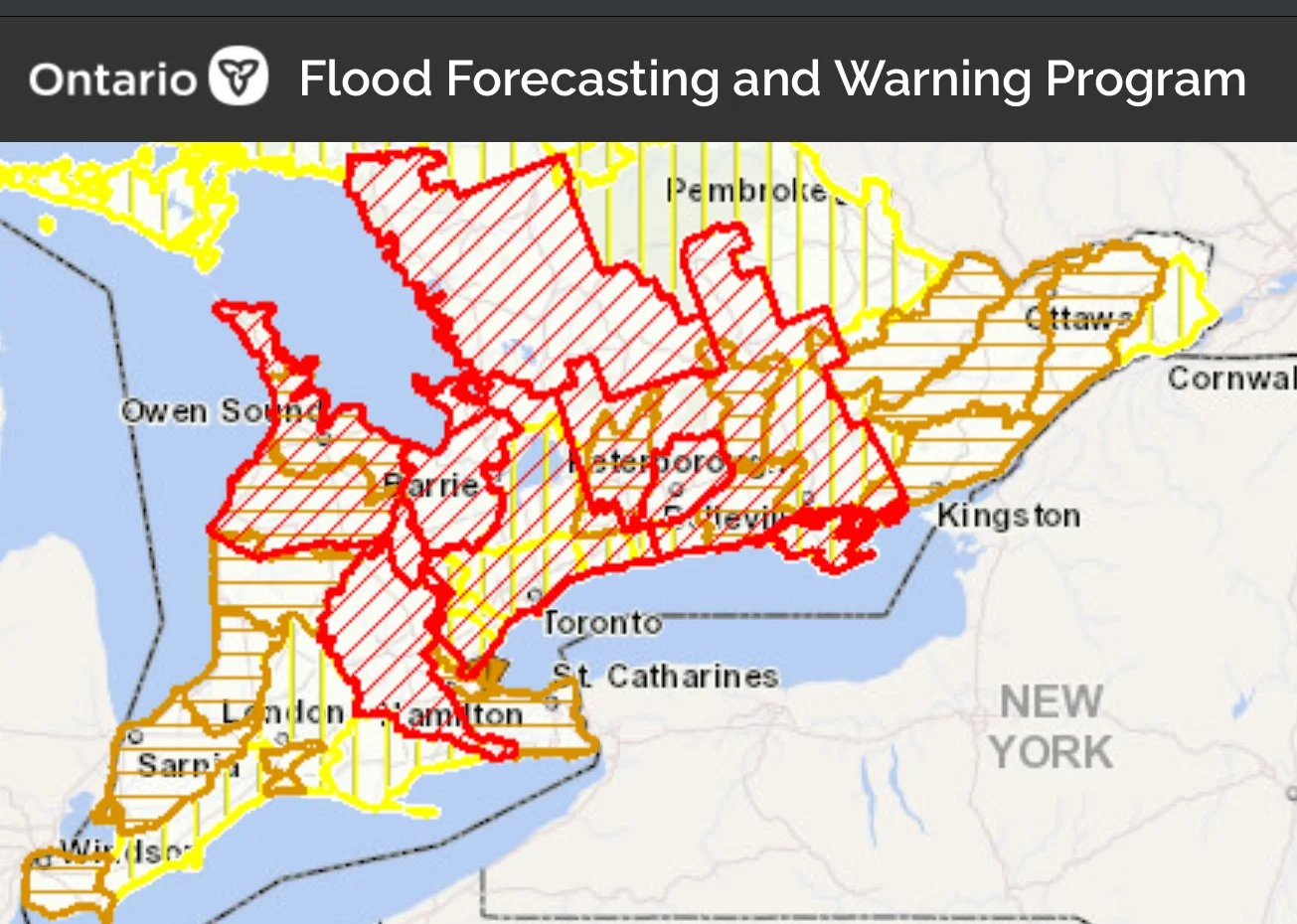
NOTE: YOU CAN CLICK ON THE image TO OPEN An interactive map

Heavy rainfall and rapid snowmelt are triggering rising water levels across much of Southern Ontario, prompting multiple flood warnings and watches being issued since this past Friday. Conservation authorities and the Ministry of Natural Resources (MNR) have issued alerts for various watersheds, warning that saturated ground conditions and increased runoff may lead to localized flooding. Residents in affected areas should remain vigilant as rivers and streams swell, with the risk of minor to moderate flooding in low-lying regions.


New Flood Warnings

The Grand River Conservation Authority (GRCA) is issuing a Flood Warning message for the City of Kitchener and the City of Cambridge. The Flood Warning message previously issued for West Montrose is being upgraded to Flood Warning Zone 2. The Flood Warning messages previously issued for Grand Valley, Waldemar, Drayton, the Village of Conestogo, New Hamburg, and Ayr remain in effect.

Weather forecast

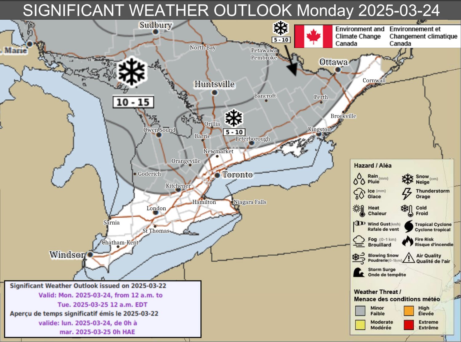
Temperatures in the watershed have increased to double digits above freezing overnight and are expected to remain high for the remainder of the day. A mixed precipitation event, including snow, freezing rain, and rain, began yesterday and continued overnight throughout the watershed. This has resulted in approximately 40 to 80 mm of total precipitation and increased runoff throughout the watershed.

Flood Warning Message for the City of Kitchener

The Grand River is expected to overflow its banks midday Thursday, April 3, increasing the risk of flooding in low-lying areas. Municipal flood coordinators in the City of Kitchener have been advised to notify affected properties and monitor conditions.

Flood Warning Message for the City of Cambridge

The Grand River is expected to overflow its banks near Water Street/Highway 24 on midday Thursday, April 3. Municipal flood coordinators in the City of Cambridge have been advised to notify affected properties and monitor conditions.

Flood Warning Message for West Montrose

River flows are expected to reach Flood Warning Zone 2 in West Montrose the afternoon of Thursday, April 3. Municipal flood coordinators in the Township of Woolwich have been advised to notify affected properties and monitor conditions. Residents are encouraged to refer to the guide on the GRCA’s website for information regarding flood warning zones.

Flood Warning Message for Grand Valley and Waldemar

River flows are expected to exceed channel capacity and peak midday Thursday, April 3. Municipal flood coordinators in Grand Valley and Waldemar have been advised to notify affected properties and monitor conditions.

Flood Warning Message for Drayton

River flows are expected to reach Flood Warning Zone 1 in Drayton on Thursday, April 3, during the morning. Municipal flood coordinators in the Township of Mapleton have been advised to notify affected properties and monitor conditions. Residents are encouraged to refer to the guide on the GRCA’s website for information regarding flood warning zones.

Flood Warning Message for the Village of Conestogo

River flows are expected to reach flooding thresholds in the Village of Conestogo midday Thursday, April 3. Municipal flood coordinators in the Township of Woolwich have been advised to notify affected properties and monitor conditions.

Flood Warning Message for New Hamburg

River flows are expected to reach Flood Warning Zone 2 in New Hamburg midday Thursday, April 3. Municipal flood coordinators in the Township of Wilmot have been advised to notify affected properties and monitor conditions. Residents are encouraged to refer to the guide on the GRCA’s website for information regarding flood warning zones.

Flood Warning Message for Ayr

River flows are expected to reach Flood Warning Zone 2 in Ayr on the morning of Friday, April 4. Municipal flood coordinators in the Township of North Dumfries have been advised to notify affected properties and monitor conditions. Residents are encouraged to refer to the guide on the GRCA’s website for information regarding flood warning zones.

This message will remain in effect until 12 p.m. on Saturday, April 5, 2025. 


Flood Warnings

MNR Districts:

- Aurora, Midhurst, Owen Sound – *Flood Warning* (April 2, 2025, 12:30 PM)

- Minden, Parry Sound, Bracebridge – *Flood Warning* (March 28, 2025, 2:30 PM)

- Peterborough, Bancroft (Burnt and Black Rivers) – *Flood Warning* (March 28, 2025, 12:00 AM)


Conservation Authorities:

- Grand River – *Flood Warning* (April 3, 2025, 8:30 AM) NEW

- Nottawasaga Valley – *Flood Warning* (April 1, 2025, 1:30 PM)

- Otonabee Region – *Flood Warning* (April 2, 2025, 1:00 PM)


Flood Watches

MNR Districts:

- Peterborough, Bancroft – *Flood Watch* (March 27, 2025, 10:00 AM)

Conservation Authorities:

- Ausable Bayfield – *Flood Watch* (April 1, 2025, 3:00 PM)

- Cataraqui Region – *Flood Watch* (April 1, 2025, 11:30 AM)

- Crowe Valley – *Flood Watch* (April 2, 2025, 2:00 PM)

- Essex Region – *Flood Watch* (April 1, 2025, 4:30 PM)

- Grey Sauble – *Flood Watch* (April 1, 2025, 11:00 AM)

- Hamilton Region – *Flood Watch* (March 31, 2025, 10:30 AM)

- Hamilton Region (High Great Lakes Level) – *Flood Watch* (April 1, 2025, 3:30 PM)

- Kawartha Region – *Flood Watch* (March 31, 2025, 12:00 AM)

- Kettle Creek – *Flood Watch* (April 2, 2025, 4:00 PM)

- Lower Trent – *Flood Watch* (April 2, 2025, 4:30 PM)

- Maitland Valley – *Flood Watch* (April 2, 2025, 10:30 AM)

- Mississippi Valley – *Flood Watch* (April 2, 2025, 4:00 PM)

- Niagara Peninsula – *Flood Watch* (April 2, 2025, 10:00 AM)

- Rideau Valley – *Flood Watch* (March 27, 2025, 4:15 PM)

- Saugeen Valley – *Flood Watch* (April 1, 2025, 12:00 AM)

- South Nation River – *Flood Watch* (March 28, 2025, 1:30 PM)

- St. Clair Region – *Flood Watch* (April 2, 2025, 11:00 PM)


Watershed and Shoreline Conditions Statements

Water Safety Statements:

- Catfish Creek – *Watershed Conditions Statement – Water Safety* (April 2, 2025, 8:30 AM)

- Ganaraska Region – *Watershed Conditions Statement – Water Safety* (April 1, 2025, 3:30 PM)

- North Bay – *Watershed Conditions Statement – Water Safety* (March 28, 2025, 3:00 PM)

- Pembroke – *Watershed Conditions Statement – Water Safety* (March 28, 2025, 12:00 PM)

- North Bay-Mattawa – *Watershed Conditions Statement – Water Safety* (March 28, 2025, 2:30 PM)

- Raisin Region – *Watershed Conditions Statement – Water Safety* (March 24, 2025, 10:00 AM)


Flood Outlook Statements

- Central Lake Ontario – *Watershed Conditions Statement – Flood Outlook* (April 1, 2025, 12:00 AM)

- Credit Valley – *Watershed Conditions Statement – Flood Outlook* (April 1, 2025, 11:30 AM)

- Halton Region – *Watershed Conditions Statement – Flood Outlook* (April 1, 2025, 12:00 AM)

- Lake Simcoe Region – *Watershed Conditions Statement – Flood Outlook* (April 1, 2025, 4:00 PM)

- Long Point Region – *Watershed Conditions Statement – Flood Outlook* (April 1, 2025, 3:30 PM)

- Lower Thames Valley – *Watershed Conditions Statement – Flood Outlook* (April 1, 2025, 2:00 PM)

- Quinte (Inland Lakes and Rivers) – *Watershed Conditions Statement – Flood Outlook* (March 27, 2025, 12:00 PM)

- Toronto and Region – *Watershed Conditions Statement – Flood Outlook* (April 1, 2025, 1:30 PM)

- Upper Thames River – *Watershed Conditions Statement – Flood Outlook* (April 1, 2025, 2:30 PM)

- **Shoreline Conditions Statement – Storm Surge:**

- Catfish Creek – *Shoreline Conditions Statement – Storm Surge* (December 11, 2024, 12:00 AM)


Flood Risks and Safety Tips

With continued snowmelt and upcoming rainfall, many rivers and streams remain at risk of rising beyond their banks, especially in central and eastern Ontario. The combination of warm temperatures and precipitation is accelerating runoff, leading to swollen waterways with reduced capacity to handle additional rainfall. Minor flooding in low-lying areas is expected, with localized road closures possible.

- Stay informed by monitoring local weather forecasts, special weather statements, and emergency alerts.

- Avoid low-lying areas prone to flooding and never attempt to drive through flooded roads.

- Secure outdoor belongings that could be carried away by rising waters.

- If you live in a flood-prone area, prepare an emergency kit with essentials in case of evacuation.


Final Thoughts:

As flood warnings and watches continue across parts of Southern Ontario, it's important for residents in affected areas to stay alert and prepared. The combination of rapid snowmelt, saturated ground conditions, and forecasted rainfall means that water levels could rise quickly, increasing the risk of localized flooding. Keep an eye on weather updates, follow official advisories, and take precautions to protect your home and safety. If you live in a flood-prone area, now is the time to review your emergency plan. Stay safe, stay informed, and let’s hope for drier days ahead!

⛈️Severe Thunderstorm Risk, More Freezing Rain, Heavy Rain, Snow, and Strong Wind Gusts on Wednesday in Ontario

NOTE: YOU CAN CLICK ON THE MAP TO OPEN A ZOOMABLE IMAGE

Spring storms are here, and this one is bringing a bit of everything. It will begin Wednesday morning delivering heavy rain, freezing rain, strong wind gusts, severe thunderstorms and snow depending on your location. Southwestern Ontario will see significant rainfall and a severe thunderstorm risk, while parts of central, eastern, the golden horseshoe and northeastern Ontario could face a messy mix of freezing rain, ice pellets, rain, snow and strong wind gusts, again, depending on your location. For those still recovering from last weekend’s ice storm, this storm could certainly add to the challenges. There’s also a risk for substantial snowfall in northwestern Ontario, specially in the Thunder Bay region. Further details on each area below.


⛈️Severe Thunderstorm Risk

NOTE: YOU CAN CLICK ON THE MAP TO OPEN A ZOOMABLE IMAGE

💨🌪️ Hazard(s): Wind, Tornado, Thunderstorms
📍 Location: Extreme southwestern Ontario
Timing: Late Wednesday afternoon and evening.
⚠️ Impact(s): Loose objects may be tossed, possible power outages

🔎 Confidence: Low
💥 Impact: High

A line of severe thunderstorms could cross into the province from Michigan, possibly producing wind gusts up to 100 km/h. A brief tornado is also possible on this line. There is lots of uncertainty in this occurring as ingredients to form these thunderstorms are located well south of the border and will rely on the thunderstorms being able to develop there and reach southwestern Ontario before weakening. Refer to the Wednesday Significant Weather discussion for rainfall information.


🌧️ Heavy Rain, 🧊 Ice, 💨 Strong Wind Gusts, and ❄️ Snow

NOTE: YOU CAN CLICK ON THE MAP TO OPEN A ZOOMABLE IMAGE

📍 Location: Southwestern Ontario

🌧️ Hazard(s): Rain
📍 Location: Southwestern Ontario
Timing: Wednesday morning into Thursday morning
⚠️ Impact(s): Possible flooding in low-lying areas

🔎 Confidence: Moderate
💥 Impact: High

Rain is expected and may be accompanied by thunderstorms. Rainfall amounts up to 60 mm are possible by late Wednesday evening, with additional amounts expected on Thursday. Totals will vary, with areas east of Lake Huron receiving up to 60 mm, while regions near Lake Erie will likely see 10 to 20 mm.


📍 Location: Grey and Bruce Counties east to Peterborough

🧊🌧️ Hazard(s): Ice, Rain
📍 Location: Grey and Bruce Counties east to Peterborough
Timing: Wednesday midday into Thursday morning
⚠️ Impact(s): Possible flooding in low-lying areas, broken tree branches from ice build-up

🔎 Confidence: High
💥 Impact: High

Freezing rain, possibly mixed with ice pellets, is expected to bring 4 to 8 mm of ice accretion on some surfaces, particularly over higher terrain. Rain will follow and may be accompanied by thunderstorms. Rainfall amounts up to 40 mm are possible by late Wednesday evening, with more rain on Thursday.

⚠️ Impacts in this area may be enhanced due to recovery efforts from last weekend’s ice storm.


📍 Location: East of Lake Huron to portions of the Greater Golden Horseshoe

🌧️🧊 Hazard(s): Rain, Ice
📍 Location: East of Lake Huron to portions of the Greater Golden Horseshoe
Timing: Wednesday midday into Thursday morning
⚠️ Impact(s): Possible flooding in low-lying areas, possible icy surfaces on roads and walkways.

🔎 Confidence: Moderate
💥 Impact: High

A brief period of freezing rain is expected Wednesday afternoon, bringing 1 to 2 mm of ice accretion on some surfaces, particularly over higher terrain. Rain will follow and may be accompanied by thunderstorms. Rainfall amounts up to 50 mm are possible by late Wednesday evening, with more rain on Thursday.


📍 Location: Parts of Central, Eastern and Northeastern Ontario

❄️🧊 Hazard(s): Snow, Ice
📍 Location: East of Lake Huron to portions of the Greater Golden Horseshoe
Timing: Wednesday midday into Thursday morning
⚠️ Impact(s): Broken tree branches from ice build-up, possible difficult travel conditions

🔎 Confidence: Moderate
💥 Impact: High

A messy mix of winter precipitation is expected. Snow mixed with ice pellets will develop near midday Wednesday, with up to 5 cm possible before transitioning to freezing rain. A period of freezing rain Wednesday evening could bring 3 to 6 mm of ice accretion, especially over higher terrain.


📍 Location: North shore of Lake Ontario

🧊🌧️ Hazard(s): Ice, Rain
📍 Location: North shore of Lake Ontario
Timing: Wednesday midday into Thursday
⚠️ Impact(s): Possible icy surfaces on roads and walkways, possible flash flooding and water pooling on roads

🔎 Confidence: Moderate
💥 Impact: Low

A brief period of ice pellets or freezing rain is possible Wednesday afternoon. Rain will follow and may be accompanied by thunderstorms. Rainfall amounts up to 20 mm are possible by late Wednesday evening, with additional amounts expected on Thursday.


NOTE: YOU CAN CLICK ON THE MAP TO OPEN A ZOOMABLE IMAGE

📍 Location: Southern portions of Northeastern Ontario and portions of Eastern Ontario

❄️🧊 Hazard(s): Snow, Ice
📍 Location: Southern portions of northeastern Ontario and portions of eastern Ontario
Timing: Beginning midday Wednesday
⚠️ Impact(s): Difficult travel conditions

🔎 Confidence:
💥 Impact:

A messy mix of winter precipitation is expected. Snow mixed with ice pellets will develop Wednesday afternoon, with up to 5 cm possible before transitioning to a brief period of freezing rain.

⚠️ Confidence in ice accretion amounts is low. However, accretion is expected to remain fairly low as the freezing rain transitions to rain Wednesday night.


📍 Location: West of Lake Superior

❄️🌬️ Hazard(s): Snow, Blowing Snow
📍 Location: West of Lake Superior
Timing: Wednesday morning into Thursday morning
⚠️ Impact(s): Difficult travel conditions, reduced visibility, possible road closures

🔎 Confidence:
💥 Impact:

Snowfall amounts up to 25 cm are possible, with locally higher totals over elevated terrain. Gusty winds could lead to local blowing snow, especially near Lake Superior. Additional snowfall is expected Thursday.


📍 Location: Northwestern Ontario and north of Lake Superior

❄️ Hazard(s): Snow
📍 Location: Northwestern Ontario and north of Lake Superior
Timing: Wednesday morning into Thursday morning
⚠️ Impact(s): Difficult travel conditions

🔎 Confidence:
💥 Impact:

Snowfall amounts up to 15 cm are possible, with additional snowfall expected Thursday.


Final Thoughts:

This is shaping up to be a potentially strong system with widespread rain, ice, and snow affecting much of Ontario. Flooding, icy roads, tree damage, and power outages are all possible. For areas still recovering from last weekend’s ice storm, even small amounts of ice could exacerbate existing damage. The severe thunderstorm risk in deep southwestern Ontario is of particular concern as well.

As always, keep an eye our latest updates and prepare for rapidly changing conditions. Stay safe out there, folks!


Disclaimer: These forecasts are issued by Environment Canada and typically published via their Twitter/X accounts. We receive these forecast via a daily email and often publish them to help inform our communities.

⚠️ Significant Winter Storm Risk For Ontario This Weekend With Three Days of Freezing Rain Possible 🚨

NOTE: YOU CAN CLICK ON THE MAP TO OPEN A ZOOMABLE IMAGE

It may say spring on the calendar but Ontario could get a rude reminder that winter is not done with us quite yet! ❄️🥶 Environment Canada meteorologists are forecasting the potential for a significant winter storm this weekend that could bringing several days of freezing rain, causing icy roads, tree damage, and possible power outages across much of Southern Ontario.

*To clarify, “Southern” Ontario includes Southwestern, Central, Golden Horseshoe and Eastern regions. From many questions we’ve received, it seems that often ‘Southern Ontario’ is mistaken for ‘Southwestern Ontario’.

Meanwhile, lake effect snow will create hazardous travel conditions midweek, and this potentially significant winter storm could extend the icy mess into Sunday. Confidence remains low on exact snowfall amounts and ice accumulation, but this system looks like could pack a punch—stay prepared and watch for updates!


📅 Tuesday, March 25, 2025

NOTE: YOU CAN CLICK ON THE MAP TO OPEN A ZOOMABLE IMAGE

📍 Location: Areas east of Lake Huron & Georgian Bay

🌨️ Hazard(s): Snow
📍 Location: Areas east of Lake Huron and Georgian Bay
Timing: Tuesday
⚠️ Impact(s): Hazardous travel conditions, reduced visibility

Confidence: Moderate
Impact: Moderate

🔹 Lake effect snow will develop early Tuesday morning with local snowfall amounts of 5 to 15 cm possible.


📅 Wednesday, March 26, 2025

NOTE: YOU CAN CLICK ON THE MAP TO OPEN A ZOOMABLE IMAGE

📍 Location: Areas east of Lake Huron

🌨️ Hazard(s): Snow
📍 Location: Areas east of Lake Huron
Timing: Wednesday morning
⚠️ Impact(s): Hazardous travel conditions & Reduced visibility

Confidence: Low
Impact Level: Moderate

🔹 The lake effect snow will drift southward Tuesday night into Wednesday morning, with local snowfall amounts of 5 to 15 cm possible. Snow is expected to ease near midday.


⚠️ Friday, March 28, 2025

NOTE: YOU CAN CLICK ON THE MAP TO OPEN A ZOOMABLE IMAGE

📍 Location: Portions of southwestern Ontario and the Greater Golden Horseshoe

🧊 Hazard(s): Ice
📍 Location: Portions of southwestern Ontario and the Greater Golden Horseshoe
Timing: Friday evening
⚠️ Impact(s): Icy surfaces such as roads and walkways

Confidence: Moderate
Impact Level: High

🔹 A prolonged freezing rain event is expected to begin Friday evening, with multiple waves of freezing rain. There is still uncertainty regarding the timing and exact location of the rain/freezing rain boundary. The freezing rain is expected to continue into the weekend for parts of southern, central, and eastern Ontario.


📍 Location: Northeastern, central, and eastern Ontario, as well as eastern portions of the Greater Golden Horseshoe

🌨️ Hazard(s): Snow
📍 Location: Northeastern, central, and eastern Ontario, as well as eastern portions of the Greater Golden Horseshoe
Timing: Friday evening
⚠️ Impact(s): Hazardous travel conditions & snow-covered and slippery roads/walkways

Confidence: Low
Impact Level: Moderate

🔹 Snow will push into the region Friday evening before clearing late Friday night or early Saturday morning. Snowfall amounts remain uncertain.

NOTE: YOU CAN CLICK ON THE MAP TO OPEN A ZOOMABLE IMAGE


📍 Location: Northwestern Ontario and western portions of the North Shore of Lake Superior

🌨️ Hazard(s): Snow
📍 Location: Northwestern Ontario and western portions of the North Shore of Lake Superior
Timing: Friday
⚠️ Impact(s): Hazardous travel conditions & snow-covered and slippery roads/walkways

Confidence: Low
Impact Level: Moderate

🔹 Heavy snowfall is expected Friday morning, persisting through the day before easing Friday evening. The heaviest snowfall areas remain uncertain.


⚠️ Saturday, March 29, 2025

NOTE: YOU CAN CLICK ON THE MAP TO OPEN A ZOOMABLE IMAGE

📍 Location: Most of southern Ontario

Timing: Saturday
🧊 Hazard(s):
Ice
📍 Location: Most of southern Ontario
Timing: Saturday
⚠️ Impact(s):

  • ⚠️ Icy roads and walkways

  • 🌳 Broken tree branches from ice build-up

  • 🔌 Possible utility outages

Confidence: Too low in the extended range to assign a weather threat level
Impact Level: Potentially moderate or greater

🔹 A significant winter storm could bring an extended period of freezing rain, potentially leading to hazardous travel, minor tree damage, and power outages. Stay tuned for updates!


⚠️ Sunday, March 30, 2025

NOTE: YOU CAN CLICK ON THE MAP TO OPEN A ZOOMABLE IMAGE

📍 Location: Most of southern Ontario

🧊 Hazard(s): Ice
📍 Location: Most of southern Ontario
Timing: Sunday
⚠️ Impact(s):

  • ⚠️ Icy roads and walkways

  • 🌳 Broken tree branches from ice build-up

  • 🔌 Possible utility outages

Confidence: Too low in the extended range to assign a weather threat level
Impact Level: Potentially moderate or greater

🔹 A prolonged period of freezing rain is possible. Hazardous travel, tree damage, and power outages could occur. Stay alert for future updates!


Final Thoughts:

A messy mix of snow and freezing rain is set to impact Ontario from Friday through the weekend, bringing travel hazards, icy conditions, and possible power outages. Uncertainty remains in the details but this system has the potential to cause significant impacts—stay tuned for updates!

TLDR; Be prepared for icy conditions, charge your devices, and take caution if you must travel. 🚗💨

Be safe, folks!


Disclaimer: These forecasts are issued by Environment Canada and typically published via their Twitter/X accounts. We receive these forecast via a daily email and often publish them to help inform our communities.

Winter Isn’t Giving up Without a Fight in Parts of Ontario This Week

NOTE: YOU CAN CLICK ON THE MAP TO OPEN A ZOOMABLE IMAGE

Spring may have arrived on the calendar, but winter clearly didn’t get the memo! A late season storm is on the way to remind parts of Ontario that mother nature decides when we’re done with winter. This system will bringing hazardous travel conditions, accumulating snowfall, and blowing snow. Just when you thought it was safe to pack away the snow shovel, winter decides to throw another snowy tantrum to start off the week!


Sunday, March 23, 2025

NOTE: YOU CAN CLICK ON THE MAP TO OPEN A ZOOMABLE IMAGE

Location: North and west of Lake Superior

❄️ Hazard(s): Snow
📍 Location: North and west of Lake Superior
⏳ Timing: Sunday into Monday morning
⚠️ Impact(s): Hazardous travel conditions, reduced visibility, and possible road closures

Confidence: High
📉 Impact: Moderate

A widespread snowfall event will bring accumulations of 15 to 25 cm north and west of Lake Superior. While confidence is high for at least 15 cm, higher terrain areas could see totals closer to 25 cm, though confidence in these higher amounts remains low.

NOTE: YOU CAN CLICK ON THE MAP TO OPEN A ZOOMABLE IMAGE

Location: Northwestern Ontario and north of Lake Superior

❄️ Hazard(s): Snow
📍 Location: Northwestern Ontario and north of Lake Superior
⏳ Timing: Sunday into Monday morning
⚠️ Impact(s): Difficult travel conditions

Confidence: Moderate
📉 Impact: Moderate

Northwestern Ontario and areas northeast toward Lake Nipigon could see 5 to 15 cm of snow. The highest totals, near 10 to 15 cm, are expected close to the Minnesota border and northeastward.


Monday, March 24, 2025

NOTE: YOU CAN CLICK ON THE MAP TO OPEN A ZOOMABLE IMAGE

Location: Northeastern Ontario and parts of southern Ontario

❄️ Hazard(s): Snow
📍 Location: Northeastern Ontario and parts of southern Ontario
⏳ Timing: Monday
⚠️ Impact(s): Difficult travel conditions

Confidence: Moderate
📉 Impact: Moderate

Snow will begin late Sunday night or early Monday morning, with accumulations of 5 to 15 cm expected. However, areas in southern Ontario could see snow transition to rain showers by late morning or early afternoon, creating slushy and messy road conditions. Later in the day, snow will redevelop east of Lake Huron and Georgian Bay.

There is some uncertainty regarding how far south the heavier snow will extend, as the system's track and timing of the changeover to rain remain uncertain.

NOTE: YOU CAN CLICK ON THE MAP TO OPEN A ZOOMABLE IMAGE


Tuesday, March 25, 2025

NOTE: YOU CAN CLICK ON THE MAP TO OPEN A ZOOMABLE IMAGE

Location: Areas east of northern Lake Huron

❄️ Hazard(s): Snow, Blowing Snow
📍 Location: Areas east of northern Lake Huron
⏳ Timing: Tuesday
⚠️ Impact(s): Difficult travel conditions

Confidence: Moderate
📉 Impact: Moderate

Lake effect snow will develop early Tuesday morning, with 5 to 10 cm of snow expected. Gusty winds will create areas of blowing snow, leading to reduced visibility and hazardous travel conditions.

NOTE: YOU CAN CLICK ON THE MAP TO OPEN A ZOOMABLE IMAGE


Final Thoughts:

Winter may be running out of time, but it's making the most of its final days with multiple rounds of accumulating snow and travel impacts. The heaviest snowfall is expected north and west of Lake Superior, with lesser amounts across northwestern and northeastern Ontario. For southern Ontario, uncertainty remains regarding the transition from snow to rain, which could impact accumulation totals.

By Tuesday, lake effect snow and blowing snow east of northern Lake Huron could further worsen travel conditions. Those with travel plans should stay updated on forecasts and prepare for changing road conditions. While spring may be on the calendar, winter isn’t leaving without a fight.

Be safe, folks!


Disclaimer: These forecasts are issued by Environment Canada and typically published via their Twitter/X accounts. We receive these forecast via a daily email and often publish them to help inform our communities.

First Isolated Severe Thunderstorm Risk of the Season for Parts of Southern Ontario Sunday Afternoon and Evening

NOTE: YOU CAN CLICK ON THE MAP TO OPEN A ZOOMABLE IMAGE

It’s certainly been a while since we’ve had an isolated risk for severe thunderstorm activity in Southern Ontario, but here we are! Welcome to Spring! What we’re expecting is a line of thunderstorms and based on the time I’m writing this (11:11am), it looks like it has already begun to develop over Lake Erie. This line will continue to push to the northeast, affecting the Niagara Region and potentially all the way up to Barrie and parts of Simcoe County.

RADAR IMAGE FROM 11:12 AM EDT - MAP FROM INSTANTWEATHER PRO

Taking a look at the IW Pro app screenshot above, you can see the thunderstorm line beginning to develop over Lake Erie. We’re expecting nickel-size hail (perhaps a bit larger), strong wind gusts, torrential rain and frequent lightning with this line. Additionally, you can see a red outline of a Tornado Watch south of the border that covers areas south of Lake Erie.

An isolated tornado cannot be entirely ruled out with this system slipping past the international border and tracking into Ontario, so we’ll be keeping a very close eye on radar today. If you don’t already have our free app, InstantWeather, today may be a good day to download it so we can notify you of any rotating storms, funnel cloud reports or Environment Canada alerts.

Some models have also shown some very intense wind gusts, potentially exceeding 100km/h, especially in eastern Ontario, so we’re fairly concerned with that potential. Being an early season event, we decided to go with a Marginal (green) risk, but there certainly is a chance these storms could exceed the Slight (yellow) threshold, especially with the wind risk.

MAX WIND GUST FORECAST FROM THE HRRR MODEL - MAP FROM WEATHERBELL

In the image above, we see the HRRR model’s maximum wind gust forecast for Southern Ontario, showing some very strong winds in yellow and orange. This is just one model’s output so it’s not a guarantee. Nonetheless, if wind gusts do reach these levels, even in isolated areas, we could end up seeing some fairly strong wind damage to trees, hydro polls or perhaps even structures.

The main risk, timing wise, should begin this afternoon in the Niagara Region, with storms moving northeast from Lake Erie and that risk should continue to spread northeast into the evening hours. Generally, our main concern is for Niagara and areas north and east of Lake Ontario into eastern Ontario. However, we have highlighted parts of Southwestern Ontario, the GTHA, and Central Ontario as well, as we’ve seen some model data suggesting strong wind gusts are possible in those regions, along with hail, torrential rain, isolated flooding, frequent lightning and a small risk of an isolated tornado.

In general, the tornado risk is quite isolated. Having said that, with a potent system south of the border, there is always a chance we could see some tornado activity sneak into Ontario and based on some of the model data we’ve seen over the past couple of days, the risk of a spin-up or two cannot be ruled out.

We do plan on doing a livestream if storms continue to look strong this afternoon and evening so make sure to subscribe to our YouTube channel in order to get notified if and when we go live!

We’ll be posting more updates to our social media pages as well so if you’re on Facebook, you can find us at Ontario Storm Watch. We also have a fantastic storm reporting group on FB with Ontario Storm Reports. And if you’re on X/Twitter, you can find us at @IWeatherON.

More details ASAP and stay safe today, folks!

- Adam

Icy Mix, Flash Freeze and Strong Winds Could Bring Travel Disruptions to Ontario on Thursday

NOTE: YOU CAN CLICK ON THE MAP TO OPEN A ZOOMABLE IMAGE

Thursday, March 6, 2025: Winter Weather Hazards For Parts of Ontario

Environment Canada is forecasting a mix of snow, strong winds, and rapidly dropping temperatures for Thursday. Rain will transition to snow across much of the province, with accumulations of 5 to 10 cm expected in several areas. Strong northwest winds could reach up to 80 km/h, leading to widespread blowing snow and dangerous travel conditions, especially southeast of Lake Huron and Georgian Bay. Additionally, a sharp temperature drop will cause any standing water or wet surfaces to freeze quickly, creating hazardous icy conditions. Eastern Ontario and the Greater Golden Horseshoe will see a heightened risk of ice as rain transitions to freezing conditions throughout the day. Travelers should prepare for difficult driving conditions, reduced visibility, and potential road closures. Stay updated on this evolving system as details continue to develop.

NOTE: YOU CAN CLICK ON THE MAP TO OPEN A ZOOMABLE IMAGE

Location: Portions of central Ontario and southern portions of northeastern Ontario

  • Hazard(s): Snow, Blowing Snow, and Ice

  • Timing: Thursday

  • Impact(s): Difficult travel conditions, reduced visibility, and possible road closures.

  • Confidence: High

  • Impact Level: Moderate

Rain will transition to snow early Thursday morning, with snowfall accumulations of 5 to 10 cm expected. Alongside this snowfall, gusty northwest winds will lead to blowing snow in exposed areas. A sharp temperature drop will cause any standing water or wet surfaces to freeze quickly, creating hazardous icy conditions Thursday morning.

Location: Areas southeast of Lake Huron and Georgian Bay

  • Hazard(s): Snow, Blowing Snow, Wind, and Ice

  • Timing: Thursday

  • Impact(s): Difficult travel conditions, reduced visibility, possible road closures, and potential power outages.

  • Confidence: Moderate

  • Impact Level: High

Rain will transition to snow overnight or early Thursday morning, with 5 to 10 cm of accumulation possible. Strong northwest winds up to 80 km/h are expected, causing widespread blowing snow and dangerous whiteout conditions. The sharp temperature drop will also lead to ice formation as wet surfaces quickly freeze Thursday morning.

Location: Portions of eastern Ontario and the Greater Golden Horseshoe

  • Hazard(s): Ice

  • Timing: Thursday

  • Impact(s): Difficult travel conditions due to rapid freezing and ice buildup.

  • Confidence: Moderate

  • Impact Level: Moderate

    Rain will transition to snow Thursday morning or afternoon, accompanied by a sharp drop in temperature. Any standing water or wet surfaces are expected to freeze quickly throughout the day, leading to slick and icy conditions on roads and sidewalks.

Location: Portions of southwestern Ontario and areas northeast of Lake Erie and Lake Ontario

  • Hazard(s): Snow, blowing snow, wind, and ice

  • Timing: Thursday

  • Impact(s): Difficult travel conditions, reduced visibility, and possible road closures. Possible power outages.

  • Confidence: Moderate

  • Impact Level: Moderate

Rain will transition to snow overnight or early Thursday morning, with snowfall accumulations of 2 to 4 cm expected. Strong west or southwest winds, potentially reaching 80 km/h, may cause blowing snow in exposed areas, further reducing visibility. A sharp temperature drop will also lead to icy conditions as standing water or wet surfaces freeze rapidly Thursday morning. Travelers should prepare for hazardous road conditions and potential disruptions.


Friday, March 7, 2025: Snow Squalls & Blowing Snow

NOTE: YOU CAN CLICK ON THE MAP TO OPEN A ZOOMABLE IMAGE

Location: Southeast of Lake Superior, Lake Huron, and Georgian Bay

  • Hazard(s): Snow and blowing snow

  • Timing: Beginning Thursday evening and continuing through Friday

  • Impact(s): Possible difficult travel conditions

  • Confidence: Moderate

  • Impact: Moderate

Lake effect snow is expected to develop Thursday night and persist through Friday, bringing total snowfall amounts of 5 to 10 cm. Gusty winds may lead to areas of blowing snow, particularly in exposed locations, reducing visibility and making travel hazardous. Drivers should prepare for changing road conditions and potential delays.


Final Thoughts:

As this storm system moves through, travel across parts of Ontario will become increasingly difficult on Thursday due to a combination of snow, blowing snow, strong winds, and icy conditions. The transition from rain to snow, along with a sharp temperature drop, will create hazardous roads as wet surfaces quickly freeze. Power outages are also a concern in areas experiencing stronger winds, particularly near Lake Erie and Lake Ontario.

Lake effect snow will add to the challenges on Friday, especially southeast of Lake Superior, Lake Huron, and Georgian Bay, where accumulating snowfall and blowing snow could lead to reduced visibility and treacherous driving conditions. While uncertainty remains regarding exact snowfall totals, the potential for rapid changes in weather conditions warrants extra caution.

If you must travel, plan ahead, check road conditions frequently, and be prepared for sudden deteriorations. Stay tuned for updates as this system develops.

Be safe, folks!


Disclaimer: These forecasts are issued by Environment Canada and typically published via their Twitter/X accounts. We receive these forecast via a daily email and often publish them for our communities to see.

Flooding Risk & Heavy Snow Possible Wednesday For Parts of Ontario Says Environment Canada's Forecast

NOTE: YOU CAN CLICK ON THE MAP TO OPEN A ZOOMABLE IMAGE

A Colorado Low is expected to bring a mix of rain and snow to Ontario on Wednesday, potentially leading to flooding concerns in some areas and hazardous winter weather in others. The exact track of this system remains uncertain, and future updates may bring changes to precipitation amounts and affected areas. Here’s what Environment Canada has mentioned in their forecast:


Southern Ontario: Flooding Risk for Tuesday night - Wednesday, March 5:

Hazard: Rain
Location: East of Lake Huron, central Ontario, and portions of northeastern Ontario
Timing: Tuesday night through Wednesday
Impact: Potential flooding in low-lying areas and possible washouts near rivers, creeks, and culverts.
Confidence: Low
Impact: High

A strong system moving into the province could bring significant rainfall to these regions. The combination of heavy rain and rapid snowmelt in areas with a deep snowpack could lead to localized flooding issues. The exact track of the system remains uncertain, so be sure to stay updated as new information becomes available.

Hazard: Rain
Location: Southwestern, eastern Ontario, and the Golden Horseshoe
Timing: Tuesday night through Wednesday
Impact: Possible flooding in low-lying areas.
Confidence: Low
Impact: Moderate

Rainfall from the same system could cause flooding concerns in urban areas and places with poor drainage. While the overall flood risk is lower than in central and northeastern Ontario, localized issues remain possible due to snowmelt and prolonged rainfall.


Northeastern Ontario: Heavy Snow Possible Wednesday, March 5:

NOTE: YOU CAN CLICK ON THE MAP TO OPEN A ZOOMABLE IMAGE

Environment Canada’s forecast:

Hazard:
Snow
Location: Northeastern Ontario and areas north of Lake Superior
Timing: Wednesday
Impact: Difficult travel conditions, reduced visibility, and possible road closures.
Confidence: Low
Impact: High

While some areas receive heavy rain, northern Ontario will likely see significant snowfall, which could lead to hazardous travel conditions. The heaviest snow is expected in areas north of Lake Superior, but the exact placement of the heaviest bands will depend on the storm’s final track.


Final Thoughts:

There remains significant uncertainty regarding the exact storm track, precipitation types, and total amounts. Future updates may adjust the areas of concern and the severity of the impacts. Residents in flood-prone areas should monitor conditions closely and be prepared for potential flooding. Those in Northeastern Ontario should prepare for heavy snowfall and difficult travel conditions. Stay tuned for further updates as more details become available.


Disclaimer: These forecasts are issued by Environment Canada and typically published via their Twitter/X accounts. We receive these forecast via a daily email and often publish them for our communities to see.

'High' Risk for 30-40 CM of Snow for Ottawa & Parts of Ontario Wednesday to Friday Says Environment Canada

NOTE: YOU CAN CLICK ON THE MAP TO OPEN A ZOOMABLE IMAGE

Environment Canada is calling for a major winter storm to impact Ontario beginning Wednesday, bringing heavy snowfall, ice, and hazardous travel conditions across the province. The storm could arrive earlier than originally expected, affecting the Wednesday evening commute in several regions. High-impact winter weather will persist through Thursday, with lake-effect snow squalls expected to develop late Thursday into Friday.


Wednesday, February 12, 2025: Winter Storm Begins

NOTE: YOU CAN CLICK ON THE MAP TO OPEN A ZOOMABLE IMAGE

Southwestern Ontario to areas northeast of Toronto:

  • Hazard: Snow

  • Timing: Wednesday afternoon into Thursday

  • Impact: Significant impacts on rush hour traffic, snow-covered and slippery roads

  • Confidence: Low

  • Impact Severity: High

Snow will move into southern Ontario earlier than initially forecast, with accumulating snowfall beginning in the afternoon. This could lead to deteriorating travel conditions during the evening rush hour, particularly in urban areas. Snowfall will continue through the night into Thursday, with additional accumulations expected.

Areas near and north of Lake Erie:

  • Hazard: Snow, ice

  • Timing: Wednesday afternoon into Thursday morning

  • Impact: Possible significant rush hour disruptions, snow-covered and icy roads

  • Confidence: Low

  • Impact Severity: High

Snow will begin Wednesday afternoon but may mix with freezing rain or rain later in the evening. This transition could lead to icy surfaces, increasing travel risks into early Thursday morning. The precipitation type will depend on the storm’s exact track, which remains uncertain.


Thursday, February 13, 2025: Heavy Snow and Travel Disruptions

NOTE: YOU CAN CLICK ON THE MAP TO OPEN A ZOOMABLE IMAGE

Central and eastern Ontario:

  • Hazard: Snow

  • Timing: Wednesday night into Thursday

  • Impact: Dangerous travel conditions, reduced visibility, road closures, and transportation delays

  • Confidence: High

  • Impact Severity: High

Heavy snow, possibly exceeding 30 to 40 cm in some areas, is expected. Snowfall rates may be intense, particularly on Thursday morning, leading to significant disruptions.

Central, eastern, and northeastern Ontario:

  • Hazard: Snow

  • Timing: Wednesday night into Thursday

  • Impact: Difficult travel conditions, reduced visibility, potential road closures

  • Confidence: Moderate

  • Impact Severity: High

Snowfall totals of 15 to 30 cm are possible, with peak snowfall rates occurring overnight into Thursday morning.

Eastern Ontario near Lake Ontario:

  • Hazard: Snow, ice

  • Timing: Wednesday night into Thursday

  • Impact: Difficult travel conditions, reduced visibility, potential road closures

  • Confidence: Moderate

  • Impact Severity: High

Snow accumulations of 10 to 20 cm are expected. However, areas closer to Lake Ontario may see a transition to freezing rain or rain, limiting total snowfall amounts.

Regions near and east of Lake Huron towards Peterborough:

  • Hazard: Snow

  • Timing: Wednesday afternoon into Thursday morning

  • Impact: Difficult travel conditions, reduced visibility, possible road closures

  • Confidence: Moderate

  • Impact Severity: High

Snow, possibly heavy at times, will continue through the morning, with total accumulations of 15 to 25 cm.

Southwestern Ontario towards the Greater Toronto Area:

  • Hazard: Snow, ice

  • Timing: Wednesday afternoon into Thursday morning

  • Impact: Potentially difficult travel conditions

  • Confidence: Moderate

  • Impact Severity: High

Snow will taper off into Thursday morning, but areas near Lakes Erie and Ontario may see a transition to freezing rain or rain, which could result in icy road conditions. Areas that remain all snow may face significant travel impacts Thursday morning.

Northeastern Ontario:

  • Hazard: Snow

  • Timing: Wednesday night into Thursday morning

  • Impact: Possible difficult travel conditions

  • Confidence: Moderate

  • Impact Severity: Moderate

This region will be on the northern edge of the storm. Snowfall amounts of 10 to 15 cm are expected, but if the system tracks further north, higher totals may occur. Conversely, a more southerly track would result in lower accumulations.


Friday, February 14, 2025: Lake-Effect Snow Squalls Develop

NOTE: YOU CAN CLICK ON THE MAP TO OPEN A ZOOMABLE IMAGE

Following the main winter storm, lake-effect snow squalls are expected to develop late Thursday into Friday. These squalls could produce intense snowfall rates, strong winds, and poor visibility, further impacting travel.

Southeast of Georgian Bay:

  • Hazard: Snow, blowing snow

  • Timing: Late Thursday into Friday

  • Impact: Difficult travel conditions, reduced visibility, possible road closures

  • Confidence: Moderate

  • Impact Severity: High

Strong lake-effect snow squalls could develop, exacerbating travel conditions, especially if significant snowfall occurs with the preceding storm.

East of Lake Huron and southeast of Georgian Bay:

  • Hazard: Snow, blowing snow

  • Timing: Late Thursday into Friday

  • Impact: Possible difficult travel conditions, slippery roads

  • Confidence: Moderate

  • Impact Severity: Moderate

Localized snow squalls could develop, with rapidly changing weather conditions.

Near Lake Superior:

  • Hazard: Snow, blowing snow

  • Timing: Late Thursday into Friday

  • Impact: Possible difficult travel conditions, snow-covered roads

  • Confidence: Moderate

  • Impact Severity: Moderate

Lake-effect snow bands are expected to be highly variable, shifting frequently, which should help limit overall accumulations in any one area.


Key Takeaways:

A significant winter storm will impact Ontario Wednesday into Thursday, bringing heavy snow, ice, and hazardous travel conditions.

  • Urban areas will likely see rush hour impacts Wednesday evening due to an earlier-than-expected arrival.

  • Snowfall amounts could reach 30 to 40 cm in eastern Ontario, with 15 to 30 cm across much of central and northeastern Ontario.

  • Areas near Lake Erie and Lake Ontario could see ice accumulation due to freezing rain.

  • Lake-effect snow squalls will follow on Friday, compounding travel challenges.

Be safe, folks! We promise that winter should end sometime around spring… 🥶


Disclaimer: These forecasts are issued by Environment Canada and typically published via their Twitter/X accounts. We receive these forecast via a daily email and often publish them for our communities to see.

Impactful Winter Storm Possible Says Environment Canada For Parts of Ontario This Week With the Risk of Heavy Snow, Ice, and Dangerous Travel Conditions

NOTE: YOU CAN CLICK ON THE MAP TO OPEN A ZOOMABLE IMAGE

Environment Canada is forecasting a potentially impactful winter storm for parts of Ontario that could bring a mix of heavy snow, freezing rain, strong winds, and dangerous travel conditions. Potentially hazardous winter weather could begin as early as Wednesday evening and continue into the weekend with snow squalls behind the main system. Some areas could see snowfall totals exceeding 30 cm, while others may face icy conditions due to freezing rain. Blowing snow and strong winds could lead to whiteout conditions, power outages, and road closures. While there remains quite a bit of uncertainty in the exact track and intensity of this storm, it’s certainly worth discussing and paying attention to over the next few days.


Monday, February 10, 2025

NOTE: YOU CAN CLICK ON THE MAP TO OPEN A ZOOMABLE IMAGE

Sault Ste. Marie North to Montreal River Harbour

  • Hazard(s): Snow, blowing snow

  • Timing: Overnight into Monday

  • Impact(s): Hazardous travel conditions, reduced visibility, and road closures.

  • Confidence: Moderate

  • Impact: High

Details: Snow squalls will continue through Monday, with some areas receiving an additional 30 cm. Winds will increase Monday afternoon, producing blowing snow. Snow squalls will taper off before Tuesday morning.

Agawa – Lake Superior Park

  • Hazard(s): Snow, blowing snow

  • Timing: Afternoon and evening

  • Impact(s): Difficult travel conditions, reduced visibility, and possible road closures.

  • Confidence: Low

  • Impact: Moderate

Details: Snow squalls south of the area may move north Monday afternoon, with local snowfall amounts of 5 to 15 cm possible before they shift back south Monday evening. Winds will increase Monday afternoon, producing blowing snow.

Regions Southeast of Georgian Bay

  • Hazard(s): Snow

  • Timing: Overnight into Monday afternoon

  • Impact(s): Hazardous travel conditions, reduced visibility, and road closures.

  • Confidence: Moderate

  • Impact: High

Details: Snow squalls will continue into Monday afternoon, with some areas receiving an additional 20 cm.

The Bruce Peninsula and Areas East of Georgian Bay

  • Hazard(s): Snow

  • Timing: Overnight into Monday

  • Impact(s): Difficult travel conditions, reduced visibility, and possible road closures.

  • Confidence: Moderate

  • Impact: Moderate

Details: Snow squalls ongoing over the Bruce Peninsula will taper off Monday morning. Snow squalls over regions southeast of Georgian Bay will shift north Monday afternoon. Local snowfall amounts of 5 to 15 cm are possible.


Wednesday, February 12 (evening) – Thursday, February 13, 2025

NOTE: YOU CAN CLICK ON THE MAP TO OPEN A ZOOMABLE IMAGE

Greater Golden Horseshoe and Eastern Ontario

  • Hazard(s): Snow, blowing snow

  • Timing: Wednesday evening into Thursday

  • Impact(s): Hazardous travel conditions, reduced visibility, road closures, snow-covered and slippery surfaces.

  • Confidence: Low

  • Impact: High

Details: A low-pressure system will move in Wednesday evening. Snowfall could be heavy at times, with 15 to 30 cm possible. Blowing snow may reduce visibility. If the system tracks further north, areas along the north shore of Lake Ontario could see ice pellets and freezing rain instead of heavy snow. If it tracks south, snowfall amounts may be lower.

Southwestern and Central Ontario

  • Hazard(s): Snow, blowing snow

  • Timing: Wednesday evening into Thursday

  • Impact(s): Hazardous travel conditions, reduced visibility, road closures, snow-covered and slippery surfaces.

  • Confidence: Low

  • Impact: High

Details: A low-pressure system will bring snowfall of 10 to 20 cm, with potential blowing snow reducing visibility. Snow squalls may develop behind the system Thursday afternoon, especially southeast of Lake Huron and Georgian Bay. Track uncertainty remains high, and outlooks may change significantly.

North Shore of Lake Erie

  • Hazard(s): Snow, freezing rain

  • Timing: Wednesday evening into Thursday morning

  • Impact(s): Hazardous travel conditions, icy surfaces on roads and walkways.

  • Confidence: Low

  • Impact: High

Details: A mix of heavy snow, ice pellets, and freezing rain is possible, depending on the storm’s track. A more southern track may bring up to 15 cm of snow, while a northern track could result in more freezing rain. Forecast confidence is low, and updates will be necessary.

Bruce Peninsula and Portions of Central & Northeastern Ontario

  • Hazard(s): Snow, blowing snow

  • Timing: Wednesday evening into Thursday

  • Impact(s): Difficult travel conditions, reduced visibility, possible road closures.

  • Confidence: Low

  • Impact: Moderate

Details: A low-pressure system will bring snowfall of 5 to 15 cm, with blowing snow reducing visibility. Track uncertainty remains high, and outlooks may change significantly.

NOTE: YOU CAN CLICK ON THE MAP TO OPEN A ZOOMABLE IMAGE

Far Northern Ontario (Along Hudson Bay & Manitoba Border)

  • Hazard(s): Extreme cold

  • Timing: Wednesday morning

  • Impact(s): Risk of hypothermia and frostbite if outside for prolonged periods without adequate protection.

  • Confidence: Low

  • Impact: Moderate

Details: Wind chill values of -40 to -45 are possible, creating dangerous conditions for exposed skin. Proper winter gear is essential.


While quite a bit of uncertainty remains regarding the exact intensity and placement of snowfall, wind gusts, and freezing rain, confidence continues to increase that parts of Ontario will experience yet another high-impact winter event. Those with travel plans should closely monitor for updates as this develops.

We’ll continue to provide updates as more details become available. Stay safe and stay prepared!


Disclaimer: These forecasts are issued by Environment Canada and typically published via their Twitter/X accounts. We receive these forecast via a daily email and often publish them for our communities to see.

Significant Winter Storm For Parts of Ontario Possible This Weekend Says Environment Canada

NOTE: YOU CAN CLICK ON THE MAP TO OPEN A ZOOMABLE IMAGE

A prolonged and dynamic winter storm is set to impact Ontario beginning Thursday, bringing a combination of heavy snow, strong winds, freezing rain, and hazardous travel conditions across multiple regions. Confidence remains high that this system will bring significant impacts, but uncertainty exists regarding the precise track and intensity of each hazard. Here’s what to expect:


Thursday, February 6, 2025

NOTE: YOU CAN CLICK ON THE MAP TO OPEN A ZOOMABLE IMAGE

East of Lake Superior
A powerful winter storm will bring heavy snowfall, strong winds, and widespread blowing snow, making travel extremely hazardous. Whiteout conditions are possible, particularly in open areas.

  • Wind gusts up to 90 km/h, especially near Lake Superior

  • Widespread snowfall with lake effect snow contributing to accumulations up to 20 cm

  • Power outages likely due to strong winds and heavy snow

  • Winds should ease late Thursday night into Friday morning

Manitoulin Island, Grey/Bruce Region, and East of Georgian Bay
Strong winds and blowing snow will create dangerous conditions across these regions Thursday evening, with near-zero visibility in exposed areas.

  • Wind gusts up to 90 km/h possible near Lake Huron and Georgian Bay

  • Loose snow and strong winds will result in blowing snow and whiteout conditions

  • Winds will ease Thursday night into Friday

North of Lake Superior
A strong snow system will move in during the morning and afternoon, leading to difficult travel conditions.

  • Snowfall amounts up to 15 cm

  • Local blowing snow may further reduce visibility

Northern and Far Northern Ontario
Snow and blowing snow will create hazardous conditions early Thursday morning, with worsening visibility in the afternoon as winds increase.

  • Snowfall amounts up to 10 cm

  • Wind gusts up to 60 km/h will lead to blowing and drifting snow, making travel difficult

Southwestern Ontario and the Greater Golden Horseshoe
A wintry mix of freezing rain and freezing drizzle could create slippery conditions overnight Wednesday into Thursday afternoon.

  • Areas around Windsor are at the highest risk of accumulating freezing rain

  • Icing may also occur across much of southern Ontario due to freezing drizzle mixed with snow

  • Roads and sidewalks could become extremely slick before temperatures rise above freezing later in the day

Northern, Central, and Eastern Ontario
A broad swath of snow will move through these regions overnight Wednesday into Thursday, leading to travel disruptions.

  • Snowfall amounts of 5 to 10 cm expected


Friday, February 7, 2025

NOTE: YOU CAN CLICK ON THE MAP TO OPEN A ZOOMABLE IMAGE

Areas Southeast of Lake Superior
Lake effect snow squalls will take hold Thursday night and persist into Friday night, producing locally heavy snowfall and whiteout conditions.

  • Snow accumulations of 15 to 25 cm possible

  • Wind gusts up to 70 km/h will create blowing snow and significantly reduced visibility, especially Friday morning

  • Road closures may occur in some areas

Bruce Peninsula and Areas Southeast of Georgian Bay
Similar to regions southeast of Lake Superior, lake effect snow squalls will develop early Friday and continue into the evening.

  • Snowfall accumulations of 10 to 20 cm possible

  • Winds gusting to 70 km/h will result in blowing snow and travel disruptions

Southern Ontario from Goderich to Oshawa
Brief but intense snow squalls combined with strong winds may create periods of dangerous driving conditions overnight Thursday into early Friday.

  • Winds gusting to 70 km/h could cause visibility to drop suddenly in blowing snow

  • Conditions should improve by Friday morning

Prince Edward County
Strong winds will sweep through Friday morning, potentially causing minor damage and tossing unsecured objects.

  • Wind gusts up to 80 km/h expected


Saturday, February 8, 2025

NOTE: YOU CAN CLICK ON THE MAP TO OPEN A ZOOMABLE IMAGE

Southern Ontario
A new low-pressure system is expected to move into the region Saturday afternoon, bringing additional snowfall that will persist into Sunday morning.

  • Snowfall amounts near 5 cm Saturday evening, with more possible Sunday

  • Some uncertainty remains regarding the timing and track of this system


Sunday, February 9, 2025

NOTE: YOU CAN CLICK ON THE MAP TO OPEN A ZOOMABLE IMAGE

Southern Ontario West of Oshawa
The storm system from Saturday will continue into Sunday, bringing a second round of snowfall.

  • Another 5 to 10 cm of snow is expected Sunday morning

  • Total snowfall accumulations of 10 to 15 cm possible

  • Difficult travel conditions anticipated

Southern Ontario North of Lake Ontario
A winter system will deliver a widespread snowfall event beginning Saturday evening and lasting into Sunday morning.

  • Snowfall accumulations of 10 to 15 cm possible

  • Uncertainty remains regarding the track, which may impact snowfall amounts


While some uncertainties remain regarding the exact intensity and placement of snowfall, wind gusts, and freezing rain, confidence is increasing that Ontario will experience a prolonged and high-impact winter event. Those with travel plans should closely monitor forecasts, as conditions may deteriorate quickly.

We’ll continue to provide updates as more details become available. Stay safe and stay prepared!


Disclaimer: These forecasts are issued by Environment Canada and typically published via their Twitter/X accounts. We receive these forecast via a daily email and often publish them for our communities to see.

Multi-Day Snowfall & Freezing Rain Event Targets Ontario This Week Says Environment Canada

NOTE: YOU CAN CLICK ON THE MAP TO OPEN A ZOOMABLE IMAGE

A complex and potentially high-impact winter storm is set to affect portions of Ontario this week, bringing a mix of snow, freezing rain, and difficult travel conditions over several days. While there is still some uncertainty regarding the exact track and intensity of this system, below are the details from Environment Canada’s latest forecast.


Monday: Snow & Freezing Rain for Central & Eastern Ontario

A low-pressure system tracking across Ontario will bring up to 10 cm of snowfall to parts of central and eastern Ontario on Monday. In the afternoon, there is also a risk of freezing rain or freezing drizzle, which could make roadways slick and hazardous.

NOTE: YOU CAN CLICK ON THE MAP TO OPEN A ZOOMABLE IMAGE

  • Hazard: Snow and possible freezing rain

  • Location: Central and eastern Ontario

  • Timing: Monday

  • Confidence Level: Moderate

  • Potential Impacts: Slippery roads and difficult travel conditions

NOTE: YOU CAN CLICK ON THE DISCUSSION TO OPEN A ZOOMABLE IMAGE

While this system is not expected to be particularly severe, even a light glaze of ice on top of fresh snowfall can make for treacherous road conditions. Drivers should allow extra time for travel and be prepared for rapidly changing weather conditions.


Wednesday Evening: Freezing Rain Targets Southwestern Ontario

By midweek, another low-pressure system is expected to track across southern Ontario, bringing the potential for freezing rain across portions of southwestern Ontario. Ice accumulations of 5 to 10 mm could occur, significantly increasing the risk of hazardous road conditions.

NOTE: YOU CAN CLICK ON THE MAP TO OPEN A ZOOMABLE IMAGE

  • Hazard: Freezing rain

  • Location: Southwestern Ontario

  • Timing: Wednesday evening

  • Confidence Level: Low (track and timing uncertain)

  • Potential Impacts: Significant impacts on rush hour traffic and difficult travel conditions

NOTE: YOU CAN CLICK ON THE DISCUSSION TO OPEN A ZOOMABLE IMAGE

At this point, uncertainty remains high regarding the exact location and duration of the freezing rain event. However, if ice accumulation reaches the higher end of projections, travel disruptions and potential power outages could be a concern. Stay tuned for updates as more details become available.


Overnight Wednesday into Thursday: Freezing Rain for Southern Ontario

As the system continues moving east, freezing rain may expand into portions of southern Ontario overnight Wednesday and continue into Thursday afternoon. Ice accumulation of up to 5 mm is possible, leading to potentially treacherous conditions during the Thursday morning commute.

NOTE: YOU CAN CLICK ON THE MAP TO OPEN A ZOOMABLE IMAGE

  • Hazard: Freezing rain

  • Location: Southern Ontario

  • Timing: Wednesday overnight into Thursday afternoon

  • Confidence Level: Low (track and amounts still uncertain)

  • Potential Impacts: Significant travel disruptions during morning rush hour

NOTE: YOU CAN CLICK ON THE DISCUSSION TO OPEN A ZOOMABLE IMAGE

With temperatures hovering near the freezing mark, even a thin layer of ice could make roads extremely slippery. If the system strengthens, some areas could experience prolonged freezing rain, increasing the likelihood of ice buildup on roads, trees, and power lines.


Thursday: Snow & Ice for Northern Ontario

While southern Ontario deals with freezing rain, northern regions will likely see a combination of snow and ice on Thursday. Areas in eastern and northeastern Ontario could see up to 15 cm of snowfall, along with a risk of freezing rain.

NOTE: YOU CAN CLICK ON THE MAP TO OPEN A ZOOMABLE IMAGE

  • Hazard: Snow and freezing rain

  • Location: Portions of southern and northern Ontario

  • Timing: Thursday

  • Confidence Level: Low

  • Potential Impacts: Difficult travel conditions, slippery roads, and potential power outages

NOTE: YOU CAN CLICK ON THE DISCUSSION TO OPEN A ZOOMABLE IMAGE

As with earlier parts of this system, uncertainty remains about the exact track and timing, which will determine snowfall amounts and areas most affected by ice.


Final Thoughts: Stay Alert & Prepare for Winter Hazards

While there’s still uncertainty about exact details, this system has the potential to create dangerous travel conditions across multiple days. With the possibility of accumulating snow, freezing rain, and icy roads, anyone traveling this week should stay informed and plan ahead.

✔️ Check for updates – Weather forecasts will continue to shift and change as new data becomes available.
✔️ Prepare for icy conditions – If freezing rain materializes, roads could become extremely slick, and power outages may occur.
✔️ Allow extra time for travel – Winter storms can lead to slower commutes and dangerous driving conditions.

As always, we’ll be watching this system closely and providing updates as more details emerge. Stay safe and keep an eye on our free Instant Weather app for real-time notifications!


Disclaimer: These forecasts are issued by Environment Canada and typically published via their Twitter/X accounts. We receive these forecast via a daily email and often publish them for our communities to see. We also zoom them in and add more city & town names for more significant events to ensure our community can quickly determine where they are located on the map and what impacts may affect them.