Southern Ontario: School Bus Cancellations and Closures for Tuesday, April 8, 2025

Published: February 12, 2025 - 10:15 PM AT

**Please refresh your page every few minutes to receive the latest update**

Cancellation & Closure Map (English Public and Catholic Schools)

Please note: School board boundaries are a rough estimate. Don’t use this map to determine what school board or weather zone you live in as accuracy isn’t guaranteed.

  • Green = No Cancellations

  • Red = Cancellations (Click for More Details)

  • Purple = School Closures (Click for More Details)

List of Cancellations & Closures

English Public and Catholic Schools

  • Near North Public & Nipissing-Parry Sound CathoIic: Bussing for all weather corridors are cancelled today.

  • Renfrew County Public & Renfrew County Catholic: Zone 4 Madawaska area transportation services only are cancelled.


French Schools

  • Le Conseil scolaire public du Nord-Est de l’Ontario (CSPNE) & Conseil scolaire catholique Franco-Nord: Bussing for all weather corridors are cancelled today.

Southern Ontario: School Bus Cancellations and Closures for Thursday, April 3, 2025

**Please refresh your page every few minutes to receive the latest update**

Cancellation & Closure Map (English Public and Catholic Schools)

Please note: School board boundaries are a rough estimate. Don’t use this map to determine what school board or weather zone you live in as accuracy isn’t guaranteed.

  • Green = No Cancellations

  • Red = Cancellations (Click for More Details)

  • Purple = School Closures (Click for More Details)

List of Cancellations & Closures

English Public and Catholic Schools

  • Dufferin-PeeI Catholic: Buses to St Andrew, St Peter, St Benedict and RF Hall are cancelled

  • Kawartha Pine Ridge Public & Peterborough Victoria Northumberland Clarington Catholic: There continues to be some transportation disruptions this morning following the ice storm. Please visit www.stsco.ca for Peterborough, Northumberland, and Clarington or www.mybustoschool.ca for details. The following schools remain closed:

    NORTHUMBERLAND/QUINTE WEST:

    Camborne Public School, Plainville Public School, & Roseneath Centennial Public School

    CITY AND COUNTY OF PETERBOROUGH:

    Buckhorn Public School, Crestwood Intermediate School and Crestwood Secondary School, Norwood District Public School, Norwood Intermediate School and Norwood District High School, & Warsaw Public School

    CITY OF KAWARTHA LAKES:

    St. Luke Catholic Elementary School

  • Near North Public & Nipissing-Parry Sound CathoIic: Busses are cancelled for the Redbridge/Thorne weather zone.

  • PeeI Public: All transportation to RF Hall SS is cancelled today due to cancellations in Dufferin County.

  • Rainbow Public & Sudbury Catholic: Morning busses are cancelled for Sudbury, Espanola, and Massey. Busses will run this afternoon.

  • Renfrew County Public & Renfrew County Catholic: All busses are cancelled.

  • Simcoe County Public & Simcoe Catholic: Busses are cancelled for Muskoka. The following schools remain closed:

    SIMCOE COUNTY PUBLIC:

    Brechin PS, East Oro PS, Forest Hill PS, Goodfellow PS, Guthrie PS, Holly Meadows ES, Marchmont PS, Rama Central PS, Severn Shores PS, Shanty Bay PS, Uptergrove PS, WR Best Memorial PS & All City of Orillia Schools.

    SIMCOE MUSOKA CATHOLIC:

    All schools in Muskoka and Orillia.

  • Trillium Lakelands: Transportation is not running in Zones 4 and 5 due to the ice storm. The following schools remain closed:

    ZONE 1:

    Glen Orchard Public School & Honey Harbour Public School,

    ZONE 3:

    Cardiff Elementary School

    ZONE 4:

    Bobcaygeon Public School, Fenelon Township Public School, Lady Mackenzie Public School, Ridgewood Public School & Woodville Elementary School

    ZONE 5:

    Dr. George Hall Public School, Jack Callaghan Public School, & Mariposa Elementary School

  • Upper Grand Public & Wellington CathoIic: Busses are cancelled for North Wellington (Division 3) and Dufferin County & Robert F. Hall (Division 4).


French Schools

  • Conseil des écoles publiques de l’Est de l’Ontario (CEPEO): Busses are cancelled for Renfrew County

  • Conseil catholique MonAvenir: École élémentaire catholique Samuel-de-Champlain remains closed.

  • Conseil scolaire public du Grand Nord de l’Ontario (CSPGNO): Morning busses are cancelled for Sudbury, Espanola, and Massey. Busses will run this afternoon.

  • Le Conseil scolaire public du Nord-Est de l’Ontario (CSPNE) & Conseil scolaire catholique Franco-Nord: Busses are cancelled for the Redbridge/Thorne weather zone.

Weathering the Storm: How to Prepare For an Ice Storm

In advance of the ice storm anticipated to impact the province, we at Instant Weather want to make sure that everyone is ready in the event of potential widespread and long term power outages. The impact of an ice storm is not just dependent on the amount of ice accretion, but also the winds associated with the storm. This is summarized using the Sperry-Piltz Ice Accumulation (SPIA) Index shown below.

It is important to be prepared for these situations so we have put together a list of items you should have on hand in case of an emergency:

  • Flashlight (windup or battery operated)

  • Radio (windup or battery operated)

  • Extra batteries

  • Portable cell phone charger

  • Water (2 litres per person per day)

  • Non-perishable canned or dried food

  • Manual can opener

  • Blankets

  • Candles and matches or lighters

  • First aid kit and any prescriptions/medical items

  • List of emergency numbers

  • Cash

  • Gasoline

Not sure what kind of food to have ready? Dried food like rice and pasta along with canned tuna can go a long way. Other items such as bread and granola bars are good for fibre and non-refrigerated fruits like bananas, oranges and apples help break up the high-sodium content found in dried foods. Another staple for many are storm chips. For water, an easy way to store a large amount is to fill a bathtub and use the water for drinking, cooking, and flushing toilets.

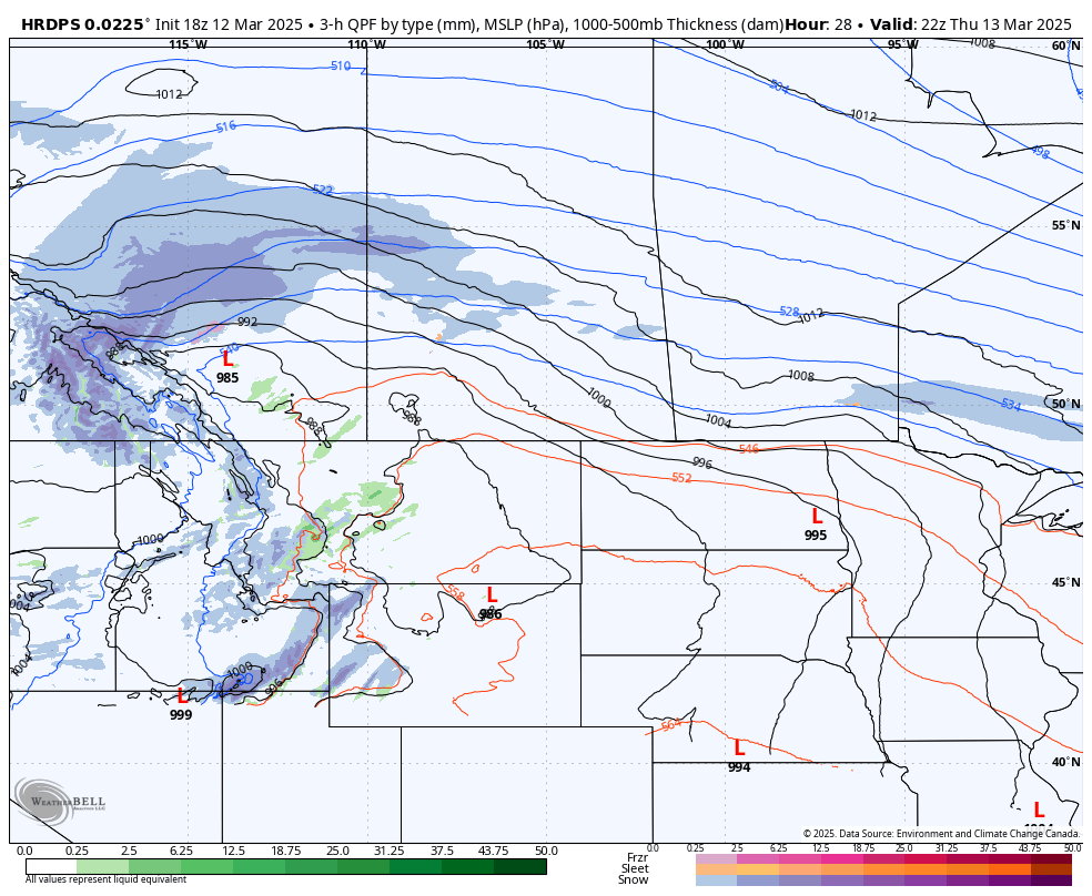
Since ice storms occur during the winter and early spring months, keeping warm is a major concern during extended power outages from ice storms. Electric baseboard heaters and space heaters will not work. However, natural gas furnaces will still work, but electrical components such as the blower, which forces the warm air through the vents, will not. There are some propane heaters that can be used indoors, but be careful because outdoor propane heaters produce carbon monoxide, making them very dangerous to use inside a home.

Another item worth adding to your emergency kit arsenal is a generator. Generators are available in a variety of sizes and capacities based on individual needs. There are a few things to consider when picking a generator: type, power and additional features.

There are home standby generators that are permanently in place and start up automatically when the power goes out. These units are large and can be quite expensive. There are also smaller, portable generators that either run strictly on gas or on either gas or propane (dual fuel). There is an added benefit of running your generator on propane as it less expensive to run.

Every generator has two power ratings: starting watts and running watts. In order to determine the power of generator you need, you first need to determine what appliances will be running. In the event of an emergency, you may find that the only necessities are the fridge and furnace fan.

It is EXTREMELY important to not run a generator in your house due to the risk of carbon monoxide poisoning.

With proper planning and preparation, everyone should be able to get through the stress that comes with extended periods without power. In the case of an ice storm, it’s important to stay indoors and reduce unnecessary travel. Also, we recommend not clogging up emergency lines with non-emergencies. Your power will be back before you know it!

Significant Spring Storm Expected to Dump up to 20cm and Possibly Locally Higher Amounts Across the Prairies

NOTE: YOU CAN CLICK ON THE MAP TO OPEN A ZOOMABLE IMAGE

It’s simply not spring in the Prairies without at least one major snowstorm and this year will be no different! A low pressure system will track across the region over the next couple of days, bringing widespread 10-20cm to all three Prairie provinces by the end of the work week. What makes this storm more interesting is that while some areas could see up to 20cm of snow, others could see temperatures approaching 20°C, particularly in Southern Alberta and Southwest Saskatchewan!

The precipitation will begin Wednesday evening as rain across parts of Central Alberta. As the temperatures fall later in the evening, the rain will transition to snow, which will then spread both southward and eastward overnight and into early Thursday morning. A bit of rain will persist along the southern edge of precipitation into the morning, but it will eventually also transition over to snow, with a chance for some brief freezing rain in between.

Model Image showing the location and intensity of snow (Blue), Rain (Green), and Freezing rain (Pink) at 4AM MT Thursday

It’s during the early morning hours of Thursday that the snow will push into Saskatchewan while also starting to intensify across Central Alberta. As the morning continues, the heavy snow will cross into Saskatchewan, spreading southeastward across the province throughout the remainder of the morning and into the early afternoon. The snow will then spread into Southern Manitoba Thursday afternoon with the heavier snow beginning in the evening.

The heavy snow will fall for several hours, leading to rapid accumulation of up to 20cm across the region, with the possibility of pockets where up to 25cm could fall. The band of heavy snow will start to taper off early Friday morning, but light snow is expected to continue throughout the day, with the possibility of periods of heavier snow in both Saskatchewan and Manitoba.

Model Image showing the location and intensity of snow (Blue), Rain (Green), and Freezing rain (Pink) at 6PM CT Thursday

Wind gusts are expected to be up to 60km/h throughout the event and along with the heavy snow, travel may be difficult at times due to blowing snow. This could result in some isolated road closures in the hardest hit areas so make sure to check your local road conditions before going out over the next few days.

Up to 20cm of Additional Snow Expected With Second Storm of the Week

NOTE: YOU CAN CLICK ON THE MAP TO OPEN A ZOOMABLE IMAGE

The week of active weather continues in Maritimes with our second storm arriving late Wednesday, bringing a mixture of rain and snow to the region straight through to the end of the day Thursday.

This new system will move into Western Nova Scotia and Southwest New Brunswick Wednesday evening as mostly rain with a bit of snow. The precipitation with quickly spread eastward throughout the evening and subsequent falling temperatures will signal the beginning of the transition from rain to snow.

Model Image showing the location and intensity of snow (Blue), Rain (Green), and Freezing rain (Pink) at 2AM AT Thursday

After midnight, as the leading edge of the precipitation moves into Prince Edward Island, the snow will start to intensify in New Brunswick and Nova Scotia. The heavier snow will be somewhat scattered across New Brunswick, but it will be both more organized and heavier in Eastern Mainland Nova Scotia, Cape Breton Island and into Kings County, PEI.

The heavier snow is expected to persist through Thursday morning before tapering off in the early afternoon for Nova Scotia. Light snow is expected to continue in New Brunswick and PEI through the afternoon and evening, which will add a few more centimetres to the snowfall totals.

Eastern Nova Scotia, with the heaviest snowfall of the event, can expect up to 20cm by the end of the day Thursday. This will also be the case in eastern Kings County, PEI, while the rest of the Island can expect up to 10cm. Most of New Brunswick will see less than 5cm, but the heavier snowfall overnight, mixed with the lingering light snow throughout Thursday will drive totals up to 10cm in the east and into the Acadian Peninsula.

There’s the possibility of some brief snow on Friday that would only bring a couple of centimetres to the region and a significant storm on Saturday looks like it may stay offshore, but if that changes, we will provide updates!

Second Solar Eclipse in as Many Years Might Peak Through the Clouds in the Maritimes Early Saturday

Those in the Maritimes who witnessed last spring’s solar eclipse, and even those who didn’t, might be lucky enough to catch a glimpse of a partial eclipse as the Sun rises on Saturday, March 29th. The eclipse will actually begin before the sunrise and the Sun will already be partially covered as it begins to rise, so a clear view of the eastern horizon will be necessary.

The odds of the eclipse being visible, though, will be dependent on whether the clouds cooperate and we get some clear skies Saturday morning. Unfortunately, the eclipse will likely not be visible for most of the region due to cloud cover ahead of snow moving in from the west later in the day.


Timing and Coverage

While parts of the New Brunswick and Prince Edward Island experienced totality in 2024, that will not be the case this time around. The good news, however, is that the entire region will still significant sun coverage in the 80%-90% range so that if the eclipse ends up being visible in your area, you’ll be in for a treat!

Solar Eclipse Timing Across New Brunswick

   
Location   
   
Max Coverage   
   
Sunrise   
   
Maximum   
   
Partial Ends   

Bathurst

86.15%

7:06 AM

7:22 AM

8:18 AM

Edmundston

86.10%

7:17 AM

7:22 AM

8:17 AM

Fredericton

84.56%

7:11 AM

7:19 AM

8:14 AM

Miramichi

85.56%

7:06 AM

7:21 AM

8:17 AM

Moncton

84.53%

7:04 AM

7:19 AM

8:15 AM

Saint John

83.76%

7:09 AM

7:18 PM

8:13 AM

Solar Eclipse Timing Across Nova Scotia

   
Location   
   
Max Coverage   
   
Sunrise   
   
Maximum   
   
Partial Ends   

Amherst

84.20%

7:02 AM

7:19 AM

8:15 AM

Antigonish

83.63%

6:53 AM

7:19 AM

8:15 AM

Bridgewater

82.61%

7:04 AM

7:17 AM

8:12 AM

Halifax

82.82%

7:00 AM

7:17 AM

8:13 AM

Kentville

83.40%

7:03 AM

7:18 AM

8:13 AM

New Glasgow

83.71%

6:56 AM

7:19 PM

8:15 AM

Sydney

83.79%

6:46 AM

7:20 PM

8:16 AM

Truro

83.58%

6:59 AM

7:18 PM

8:14 AM

Yarmouth

82.11%

7:10 AM

7:16 PM

8:11 AM

Solar Eclipse Timing Across Prince Edward Island

   
Location   
   
Max Coverage   
   
Sunrise   
   
Maximum   
   
Partial Ends   

Alberton

85.19%

7:00 AM

7:21 AM

8:17 AM

Charlottetown

84.43%

6:57 AM

7:20 AM

8:16 AM

Kensington

84.76%

6:59 AM

7:20 AM

8:16 AM

Montague

84.33%

6:55 AM

7:19 AM

8:16 AM

Souris

84.44%

6:53 AM

7:20 PM

8:16 AM

Summerside

84.70%

7:00 AM

7:20 PM

8:16 AM

For specific eclipse coverage and timing in your location, you can go to timeanddate.com to find detailed information.

Safety Measures

Safety is paramount when viewing any solar eclipse, even a partial one. To ensure a safe and memorable experience, follow these crucial precautions:

  • Solar Viewing Glasses: Never attempt to observe the eclipse with the naked eye. Only use certified solar viewing glasses or eclipse glasses with ISO 12312-2 certification, specifically designed to protect your eyes from the Sun's harmful radiation.

  • Pinhole Projection: If eclipse glasses are unavailable, create a pinhole projector using common materials like cardboard. This indirect method allows you to project the eclipse safely onto a surface for viewing.

  • Telescopes and Binoculars: If using telescopes or binoculars, ensure they are equipped with proper solar filters to safeguard your eyes. Never aim them directly at the Sun without these protective measures.

  • Online Streaming: For those unable to view the eclipse in person or seeking a risk-free option, numerous reputable sources will provide live streaming of the event.

  • Local Eclipse Events: Consider joining local astronomy clubs or observatories hosting eclipse-viewing gatherings. These events offer expert guidance and a shared sense of community.

We’re going to continue to keep an eye on the cloud cover situation for Saturday over the coming days and will post any updates.

Spring Storm Looks to Dump Over 10cm of Snow Across Parts of New Brunswick and PEI

NOTE: YOU CAN CLICK ON THE MAP TO OPEN A ZOOMABLE IMAGE

It may be Spring now, but Winter is not giving up without a fight in the Maritimes. Snow will make its return to the region later today and continue into Tuesday morning.

The snow will begin in Western New Brunswick late this afternoon, spreading across the province through the evening. It will also start to snow lightly in Western Nova Scotia in the evening, crossing through to the eastern half of the province and into PEI later in the evening and into the overnight hours.

The snow will be steady and possibly heavy at times across New Brunswick and PEI, which will drive up accumulation totals. The snow, however, will be short-lived in Nova Scotia. After a couple of hours, the snow in Nova Scotia will transition over to rain, with a brief period of ice pellets and freezing rain in between. The majority of the precipitation from this system will end up falling as rain across Nova Scotia, with roughly 10-20mm expected across the province.

The Fundy Coast and both Kings and Queens Counties could see a bit of this mixed precipitation overnight and early Tuesday morning followed by some scattered showers. For the most part, however, both provinces can expect mostly snow over the next 24 hours. The precipitation will start to taper off from west to east during the early morning hours tomorrow and ending across the region by the mid-morning.

Overall, both New Brunswick and PEI can expect over 5cm of snow, with widespread 10-20cm likely across New Brunswick and in Prince County. In Nova Scotia, the transition to rain will limit snowfall totals to less than 5cm, but there is the possibility of more than 5cm falling in the Cape Breton Highlands.

This is just the beginning of what could be an active week for the region and we’re already watching the possibility of another storm hitting late Wednesday.

Southern Ontario: School Bus Cancellations for Monday, March 24, 2025

**Please refresh your page every few minutes to receive the latest update**

Cancellation & Closure Map (English Public and Catholic Schools)

Please note: School board boundaries are a rough estimate. Don’t use this map to determine what school board or weather zone you live in as accuracy isn’t guaranteed.

  • Green = No Cancellations

  • Red = Cancellations (Click for More Details)

  • Purple = School Closures (Click for More Details)

List of Cancellations & Closures

English Public and Catholic Schools

  • Near North Public & Nipissing-Parry Sound CathoIic: Bussing for all weather corridors are cancelled today.

  • Rainbow Public & Sudbury Catholic: All morning school related transportation services for English Catholic, English public, French Catholic and French public schools, operating in the districts of SUDBURY, ESPANOLA, MASSEY AND MANITOULIN

  • Renfrew County Public & Renfrew County Catholic: Zone 4 Madawaska area transportation services are cancelled with select cancellations in other areas and delays expected.


French Schools

  • Conseil scolaire public du Grand Nord de l’Ontario (CSPGNO): All morning school related transportation services for English Catholic, English public, French Catholic and French public schools, operating in the districts of SUDBURY, ESPANOLA, MASSEY AND MANITOULIN

  • Le Conseil scolaire public du Nord-Est de l’Ontario (CSPNE) & Conseil scolaire catholique Franco-Nord: Bussing for all weather corridors are cancelled today.

Mid-March Snowfall Will Help Build Back Some Snowpack With 10-20cm Expected Across a Wide Stretch of Alberta & Saskatchewan

NOTE: YOU CAN CLICK ON THE MAP TO OPEN A ZOOMABLE IMAGE

While we’re a little over a week away from the official start of spring, a majority of the snowpack is already gone across parts of Alberta and Saskatchewan. However, winter is still hanging on with more snow incoming over the next couple of days.

This will help to add some much-needed moisture to part of the region, especially since we have seen well below average snowfall since November. Unfortunately for Southern Alberta, the driest part of the Prairies, can expect little to none of this incoming moisture.

The snow will cross through the Rockies and into Alberta at around sunrise on Thursday and spread northeastward deeper into the province throughout the morning and into the afternoon. The snow will intensify starting in the early afternoon and this heavier snowfall will continue straight through overnight. This will lead to a large stretch of Central and Northern Alberta receiving 10-20cm of snow and up to 25cm possible to the north of Lake La Biche and Cold Lake through Friday morning.

Model Image showing the location and intensity of snow (Blue) and Rain (Green) at 4PM MT on Thursday

Light snow will make its way into Northern Saskatchewan early Thursday afternoon, followed by the more intense snowfall beginning in the early evening. This area of heavier snow will cross through Saskatchewan in an almost due easterly path and similar to in Alberta, it will dump 10-20cm across a large stretch of the province and up to 30cm from the Alberta border to almost La Ronge by Friday afternoon.

The arrival of additional moisture from a separate low-pressure system in the US on Friday morning makes the forecast in Central and Southern Saskatchewan a bit more complicated. This appears to be bringing a combination of rain, freezing rain, ice pellets, and snow to most of the southern half of the province throughout the morning as it merges with the system from the west.

There is still some uncertainty regarding the precipitation type and the area that could be impacted by the arrival of the secondary system. Therefore, for this forecast, we are only focusing on the snow coming from Alberta and we will cover this additional precipitation in a separate forecast that will be issued later in the day on Thursday

Model Image showing the location and intensity of snow (Blue), Rain (Green), Freezing rain (pink), and ice pellets (orange) at 2aM MT on Friday

More Freezing Rain & Snow in Store, Potential for Flash Freeze Across the Maritimes on Friday

NOTE: YOU CAN CLICK ON THE MAP TO OPEN A ZOOMABLE IMAGE

The moisture-laden Colorado Low that has brought a mixed bag of precipitation to the Maritimes over the past two days appears to have one last trick up its sleeve. Cold air will flood into the region overnight, transitioning the rain over to snow and bringing some further complications.

In New Brunswick, the rain will start to switch over at around 1-2AM, however there will be a couple of hours of freezing rain in Central and Northern New Brunswick once again before the change over to snow. The heaviest snow is expected to fall in Carleton and Victoria Counties and northward into Madawaska and parts of Restigouche. This region can expect 10-20cm of snow by Saturday morning and the possibility of locally higher amounts, particularly in Madawaska County. Much of the rest of the province will see 5-10cm, with the exception of along the Fundy Coast and into the Southeast and Moncton area, where less than 5cm is anticipated.

Model Image showing the location and intensity of snow (Blue), Rain (Green), Freezing rain (Pink), and Ice pellets (Orange) at 5AM AT Friday

In Western Nova Scotia, the rain will taper off in the early morning hours of Friday, but it will be replaced by snow starting at around 8-9AM. The snow will be light and short-lived for much of the western half of the Mainland, but it will remain fairly steady in the Annapolis Valley through the afternoon and into the evening, leading to 5-10cm by the end of the day.

Across the rest of Mainland Nova Scotia, snowfall will be light and scattered as the band of snow makes its way across the province, leading to up to 5cm. The snow will eventually begin in Cape Breton late Friday evening, where it will continue through to Saturday morning. Most of the Island can expect 5-10cm, with lesser amounts around Sydney and up to 20cm in the Highlands.

The snow in Prince Edward Island, like in most of Nova Scotia, will also be very light and patchy. It will reach the province in the evening and the scattered flurries will continue into Saturday morning, leading to up to 5cm across the Island.

Modelled Temperatures at 9PM Thursday

Modelled Temperatures at 1PM Friday

The drop in temperatures that will cause the transition from rain to snow has another considerable implication. Temperatures are expected to plummet to several degrees below freezing across the region, after climbing into the double digits Thursday, and when combined with the preceding rain and melt-water, most of the Maritimes is under the threat of a flash freeze occurring on Friday.

This potential flash freeze could lead to wet, untreated surfaces quickly becoming icy and making travel hazardous as the temperatures drop across the region. Adding a layer of snow on top of this ice will keep things quite slippery as well.

The winds are expected to pick up on Friday, gusting up to 70km/h through most of the afternoon and then as high as 100km/h beginning in the evening and continuing for most of Saturday. These strong winds will likely reduce visibility due to blowing snow, both during and after the snow has stopped falling, and possibly lead to localized power outages.

Southern Ontario: School Bus Cancellations for Thursday, March 6, 2025

**Please refresh your page every few minutes to receive the latest update**

Cancellation & Closure Map (English Public and Catholic Schools)

Please note: School board boundaries are a rough estimate. Don’t use this map to determine what school board or weather zone you live in as accuracy isn’t guaranteed.

  • Green = No Cancellations

  • Red = Cancellations (Click for More Details)

  • Purple = School Closures (Click for More Details)

List of Cancellations & Closures

English Public and Catholic Schools

  • Avon MaitIand Public & Huron-Perth CathoIic: There are several cancellations and school closures, please visit this link for more details: https://geoquery.hpsts.ca/Alerts

  • BIuewater Public & Bruce-Grey Catholic: There are several cancellations, please visit this link for more details: https://www.mybrucegreyschoolbus.ca/Cancellations.aspx

  • Dufferin-PeeI Catholic: Buses to St Andrew, St Peter, St Benedict and RF Hall are cancelled today. St Andrew, St Peter and St Benedict are closed.

  • Durham Public & Durham Catholic: DSTS has cancelled Zone 1, Zone 2 and Zone 3 transportation for today due to inclement weather.

  • Near North Public & Nipissing-Parry Sound CathoIic: Bussing for all weather corridors are cancelled today.

  • Kawartha Pine Ridge Public & Peterborough Victoria Northumberland Clarington Catholic: All busses are cancelled.

  • PeeI Public: All transportation to RF Hall SS is cancelled today due to cancellations in Dufferin County.

  • Rainbow Public & Sudbury Catholic: All busses are cancelled.

  • Renfrew County Public & Renfrew County Catholic: Transportation services are CANCELLED for Zone 1 (Deep River), Zone 4 (Madawaska), Zone 5 (Cobden, Douglas, Eganville)

  • Simcoe County Public & Simcoe Catholic: All busses are cancelled. Schools are closed in Muskoka.

  • Thames Valley Public & London CathoIic: ALL school purpose vehicles servicing LDCSB & TVDSB in Middlesex County, Oxford County, Elgin County, and the Red Zone will be CANCELLED

  • Tri-Board: Due to current road conditions and the expected drop in temperature, transportation is cancelled in the North Hastings weather zone today.

  • Trillium LakeIands: All busses are cancelled and schools are closed.

  • Upper Grand Public & Wellington CathoIic: Busses are cancelled for Centre Wellington, Town of Erin, Town of Rockwood (Division 2), North Wellington (Division 3), and Dufferin County and Robert F. Hall (Division 4). Schools in these Divisions are also closed.


French Schools

  • Conseil catholique MonAvenir: Disruption to school transport and/or the opening of certain schools in the following regions: Durham, Simcoe, Peterborough

  • Conseil scolaire catholique Providence: Busses are cancelled for Region of Oxford, Region of Middlesex (rural routes), Region of Bruce-Grey

  • Conseil scolaire public du Grand Nord de l’Ontario (CSPGNO): All busses are cancelled

  • Conseil scolaire Viamonde: Busses are cancelled for Region of Simcoe, Region of Durham, Region of Wellington

  • Le Conseil scolaire public du Nord-Est de l’Ontario (CSPNE) & Conseil scolaire catholique Franco-Nord: All busses are cancelled.

Southern Ontario: School Bus Cancellations for Wednesday, March 5, 2025

**Please refresh your page every few minutes to receive the latest update**

Cancellation & Closure Map (English Public and Catholic Schools)

Please note: School board boundaries are a rough estimate. Don’t use this map to determine what school board or weather zone you live in as accuracy isn’t guaranteed.

  • Green = No Cancellations

  • Red = Cancellations (Click for More Details)

  • Purple = School Closures (Click for More Details)

List of Cancellations & Closures

English Public and Catholic Schools

  • Durham Public & Durham Catholic: DSTS has cancelled Zone 1, Zone 2 and Zone 3 transportation for today due to inclement weather.

  • Near North Public & Nipissing-Parry Sound CathoIic: Bussing for all weather corridors are cancelled today.

  • Rainbow Public & Sudbury Catholic: All busses are cancelled.

  • Renfrew County Public & Renfrew County Catholic: Transportation services are CANCELLED for ALL AREAS by for Wednesday March 5, 2025 due on going Freezing Rain with mixed precipitation forecasted throughout the day.

  • Simcoe County Public & Simcoe Catholic: Busses are cancelled for Muskoka.

  • Tri-Board: Due to current road conditions, transportation is cancelled in some of Tri-Board’s north and central weather zones today. For a complete list of bus cancellations and delays visit: https://triboard.mybusplanner.ca/Alerts

  • Trillium LakeIands: All school vehicles to schools in all Zones for Trillium Lakelands District School Board have been cancelled.


French Schools

  • Conseil des écoles publiques de l’Est de l’Ontario (CEPEO): School transport is cancelled today for schools in Pembroke due to poor road conditions in this area.

  • Conseil des écoles catholiques de langue française du Centre-Est: transportation has been cancelled for schools in Pembroke due bad road conditions.

  • Conseil scolaire public du Grand Nord de l’Ontario (CSPGNO): All busses are cancelled.

  • Le Conseil scolaire public du Nord-Est de l’Ontario (CSPNE) & Conseil scolaire catholique Franco-Nord: All busses are cancelled.

Threat of Localized Flooding & Freezing Rain Risk in New Brunswick with the Arrival of a Winter Storm Wednesday

NOTE: YOU CAN CLICK ON THE MAP TO OPEN A ZOOMABLE IMAGE

A Colorado Low is set to move through the Maritimes this week, bringing a mixture of rain, freezing rain, and snow to the region, along with the risk of flooding as temperatures rise.

Brief light snow will begin in Southwestern New Brunswick at around sunrise on Wednesday, spreading northeastward into the province throughout the morning and early afternoon. There is a chance for some freezing drizzle around Saint John mixed with the snow. Meanwhile in Nova Scotia, the precipitation will fall as rain across much of the western half of the province, aside from some light snow expected in Northern Nova Scotia.

Model Image showing the location and intensity of snow (Blue), Rain (Green), Freezing rain (Pink), and Ice pellets (Orange) at 1PM AT Wednesday

By the mid-afternoon, the bulk of the moisture from the system will push eastward into the region, bringing rain to Nova Scotia and Southern New Brunswick while Central and Northern New Brunswick will start to receive snow. The precipitation will reach PEI later in the afternoon as a mix of rain and snow across the Island.

Model Image showing the location and intensity of snow (Blue), Rain (Green), Freezing rain (Pink), and Ice pellets (Orange) at 12AM AT Thursday

Starting in the evening, the warm air and rain will start to push northward, leading to a transition from snow to a few hours of freezing rain across Central and Northern New Brunswick, as well as into PEI and Cape Breton. The freezing rain will continue overnight and into early Thursday morning. Ice accretions of up to 5mm are likely, but buildup will be short-lived as the temperatures will continue to rise and the freezing rain will switch over to rain for the remainder of Thursday.

Ahead of the transition to freezing rain and rain, up to 10cm of snow will fall, with the highest amounts expected in Retigouche County and into the Acadian Peninsula.

NOTE: YOU CAN CLICK ON THE MAP TO OPEN A ZOOMABLE IMAGE

Not only will the fresh snowfall melt with the rain and temperatures climbing into the double digits on Thursday, but a considerable amount of pre-existing snowpack, especially across New Brunswick will also melt. Parts of Central and Northern New Brunswick have over 70cm of snow on the ground as of Tuesday evening and that value is expected to drop to below 50cm in some areas by Friday. Similarly, Moncton and Saint John, where 10-20cm is already on the ground, could see most, if not all, of their snow melt.

This rapid melting of the snow, along with some heavy rain expected later in the day on Thursday, has led to a significant flooding threat across New Brunswick. The ground is still frozen and recent frigid temperatures have led to ice buildup on lakes and rivers, which will limit where the water from the snow melt and rain can go.

The situation in Nova Scotia and into PEI is less widespread with lesser snowpack overall. There are some areas in Nova Scotia that have up to 30cm of snow on the ground that will almost completely melt, namely in the Annapolis Valley and in Cumberland and Colchester Counties. Those in Cape Breton can expect to see some of their snowpack melt, but the Highlands will experience very little change. In Prince Edward Island, on the other hand, next to no snow will remain on the Island come Friday aside from pockets of up to 5cm possibly remaining in Prince and/or Kings Counties.

The modelled depth of snow across Atlantic Canada, in centimetres, as of 8pm Tuesday.

Southern Ontario: School Bus Cancellations for Friday, February 28, 2025

**Please refresh your page every few minutes to receive the latest update**

Cancellation & Closure Map (English Public and Catholic Schools)

Please note: School board boundaries are a rough estimate. Don’t use this map to determine what school board or weather zone you live in as accuracy isn’t guaranteed.

  • Green = No Cancellations

  • Red = Cancellations (Click for More Details)

  • Purple = School Closures (Click for More Details)

List of Cancellations & Closures

English Public and Catholic Schools

  • Kawartha Pine Ridge Public & Peterborough Victoria Northumberland Clarington Catholic: All busses are cancelled.

  • Near North Public & Nipissing-Parry Sound CathoIic: All busses are cancelled.

  • Rainbow Public & Sudbury Catholic: All busses are cancelled.

  • Tri-Board: Transportation is cancelled in the North Hastings weather zone today.


French Schools

  • Conseil catholique MonAvenir: Busses are cancelled in the Peterborough Region

  • Conseil scolaire public du Grand Nord de l’Ontario (CSPGNO): All busses are cancelled.

  • Le Conseil scolaire public du Nord-Est de l’Ontario (CSPNE) & Conseil scolaire catholique Franco-Nord: All busses are cancelled.

Quick Blast of Intense Snowfall Could Bring Over 20cm to Parts of Saskatchewan and Manitoba

NOTE: YOU CAN CLICK ON THE MAP TO OPEN A ZOOMABLE IMAGE

February has been a quiet month across the Prairies, as far as active weather is concerned. That has changed though, with the arrival of warmer air in the past few days, which has also brought heavier snowfall back to the region. Now, we are looking at that heavy snow across Saskatchewan and Manitoba for Thursday and Friday.

The snow will begin early Thursday in Northern Saskatchewan and surge southeastward throughout most of the morning, crossing into Manitoba at around 8-9am. The snow will be steady and fairly light for most of the day, falling at up to 2cm/hr, leading to a large swath of over 10cm across both provinces.

In the late afternoon and early evening, the snow will begin to taper off in Saskatchewan while at the same time, intensifying in Central Manitoba. The heavier snow is expected to cross the province throughout the evening and will bring snowfall totals to the higher end of the 10-20cm range, with a strong likelihood of localized pockets of over 20cm, particularly around Flin Flon, The Pas and Norway House. The intensified snowfall will also be associated with some stronger wind gusts of up to 70km/h, which could result in isolated whiteouts due to blowing snow.

As the short-lived system exits the region, the snow will finally taper off in Saskatchewan shortly after midnight on Friday and in Manitoba just before sunrise. The winds are also expected to weaken Friday morning, therefore reducing the blowing snow risk.

Southern Ontario: School Bus Cancellations for Wednesday, February 19, 2025

**Please refresh your page every few minutes to receive the latest update**

Cancellation & Closure Map (English Public and Catholic Schools)

Please note: School board boundaries are a rough estimate. Don’t use this map to determine what school board or weather zone you live in as accuracy isn’t guaranteed.

  • Green = No Cancellations

  • Red = Cancellations (Click for More Details)

  • Purple = School Closures (Click for More Details)

List of Cancellations & Closures

English Public and Catholic Schools

  • Avon MaitIand Public & Huron-Perth CathoIic: There are several cancellations and school closures, please visit this link for more details: https://geoquery.hpsts.ca/Alerts

  • BIuewater Public & Bruce-Grey Catholic: There are multiple cancellations and school closures, please visit this link for more details: https://www.mybrucegreyschoolbus.ca/Cancellations.aspx

  • Dufferin-PeeI Catholic: Buses to St Andrew, St Peter, St Benedict & RF Hall are cancelled today.

  • PeeI Public: All transportation to RF Hall SS is cancelled today due to cancellations in Dufferin County.

  • Thames Valley Public & London CathoIic: There are isolated cancellations, please visit this link for more details: https://transportation.mybigyellowbus.ca/Cancellations.aspx

  • Upper Grand Public & Wellington CathoIic: Busses are cancelled for North Wellington (Division 3) & Dufferin County and RF Hall (Division 4).


French Schools

  • Conseil scolaire catholique Providence: Busses are cancelled for the Region of Bruce-Grey & Huron Perth of Middlesex Region

Southern Ontario: School Bus Cancellations for Tuesday, February 18, 2025

**Please refresh your page every few minutes to receive the latest update**

Cancellation & Closure Map (English Public and Catholic Schools)

Please note: School board boundaries are a rough estimate. Don’t use this map to determine what school board or weather zone you live in as accuracy isn’t guaranteed.

  • Green = No Cancellations

  • Red = Cancellations (Click for More Details)

  • Purple = School Closures (Click for More Details)

List of Cancellations & Closures

English Public and Catholic Schools

  • Avon MaitIand Public & Huron-Perth CathoIic: There are several cancellations and school closures, please visit this link for more details: https://geoquery.hpsts.ca/Alerts

  • BIuewater Public & Bruce-Grey Catholic: There are multiple cancellations and school closures, please visit this link for more details: https://www.mybrucegreyschoolbus.ca/Cancellations.aspx

  • Dufferin-PeeI Catholic: Buses to St Andrew, St Peter, St Benedict & RF Hall are cancelled today. St Andrew, St Peter and St Benedict are CLOSED,

  • Durham Public & Durham Catholic: DSTS has cancelled Zone 1 transportation for today

  • Kawartha Pine Ridge Public & Peterborough Victoria Northumberland Clarington Catholic: All transportation is cancelled today in Northumberland, Clarington, Peterborough City and County.

  • PeeI Public: All transportation to RF Hall SS is cancelled today due to cancellations in Dufferin County.

  • Simcoe County Public & Simcoe Catholic: Busses are cancelled in all Simcoe County zones.

  • Thames Valley Public & London CathoIic: School purpose vehicles are CANCELLED for the day in MIDDLESEX & OXFORD Counties.

  • Trillium Lakelands: All school vehicles to schools in Zone 4 and Zone 5 have been cancelled today.

  • Upper Grand Public & Wellington CathoIic: All busses are cancelled and schools are closed, except for RF Hall.

French Schools

  • Conseil catholique MonAvenir: Disruption to school transport and/or the opening of certain schools in the following regions: Wellington, Simcoe & Peterborough

  • Conseil scolaire catholique Providence: Busses are cancelled in Region of Oxford, Region of Middlesex, Region of Bruce-Grey

  • Conseil scolaire Viamonde: Busses are cancelled for the Region of Durham and the Region of Waterloo (Guelph routes)

Another Major Winter Storm Looks to Make a Mess of the Maritimes This Weekend

NOTE: YOU CAN CLICK ON THE MAP TO OPEN A ZOOMABLE IMAGE

The latest storm is barely in our rear-view mirror and we’re already looking ahead to the next one. This incoming storm, with a projected track that keeps shifting considerably over the span of a few hours between weather model runs, is slated to hit the Maritimes on Sunday and continue through most of Monday.

Similar to the storm that just hit the region, the next storm will bring a range of precipitation types due to the presence of warm air. Unfortunately, the amount of precipitation with this next storm is expected to be much greater and current projections show up to 60cm of snow possible in Northern New Brunswick and over 10mm of ice accretion across parts of Nova Scotia, PEI, and into Southern New Brunswick.

At this point, there is still some considerable uncertainty regarding the timing, precipitation types and the amount of each expected locally. This will be dependent on the exact path the storm will take as it makes its final approach into the region and how far north the warm air aloft will extend. We hope to have greater clarity of the situation over the next 24 hours and we will provide more details ASAP.

Precipitation Types with temperature profiles

Southern Ontario: School Bus Cancellations for Friday, February 14, 2025

**Please refresh your page every few minutes to receive the latest update**

Cancellation & Closure Map (English Public and Catholic Schools)

Please note: School board boundaries are a rough estimate. Don’t use this map to determine what school board or weather zone you live in as accuracy isn’t guaranteed.

  • Green = No Cancellations

  • Red = Cancellations (Click for More Details)

  • Purple = School Closures (Click for More Details)

List of Cancellations & Closures

English Public and Catholic Schools

  • Avon MaitIand Public & Huron-Perth CathoIic: There are several cancellations, please visit this link for more details: https://geoquery.hpsts.ca/Alerts

  • BIuewater Public & Bruce-Grey Catholic: There are multiple cancellations, please visit this link for more details: https://www.mybrucegreyschoolbus.ca/Cancellations.aspx

  • Simcoe County Public & Simcoe Catholic: Busses are cancelled in all zones.

  • Trillium Lakelands: Busses are cancelled for Zones 4 & 5.

  • Upper Grand Public & Wellington CathoIic: Busses are cancelled in North Wellington (Division 3) and Dufferin County & Robert F. Hall (Division 4).

French Schools

  • Conseil catholique MonAvenir: Disruption to school transport and/or the opening of certain schools in the following region: Simcoe

  • Conseil scolaire catholique Providence: Busses are cancelled for the Region of Bruce-Grey and Huron Perth of Middlesex Region

  • Conseil scolaire Viamonde: Busses are cancelled for the Region of Simcoe.

Strong Winter Storm Expected to Bring Over 30cm of Snow and Prolonged Freezing Rain to the Maritimes

NOTE: YOU CAN CLICK ON THE MAP TO OPEN A ZOOMABLE IMAGE

The winter storm that we’ve been tracking is bearing down on the Maritimes and things are going to be messy over the next couple of days. Not only will this storm bring significant amounts of snow to parts of New Brunswick and Prince Edward Island, but there is expected to be several hours of freezing rain across Nova Scotia.

The storm will make its way into the region at around 9-10am on Thursday, with snow crossing eastward into New Brunswick from Maine and Quebec. The snow will quickly cross the province throughout the remainder of the morning, with the leading edge reaching PEI by 1-2pm.

By the early afternoon, more intense snowfall will begin to fall in New Brunswick. This heavy snow will persist for several hours across most of Central and Northern New Brunswick, at rates of 3-5cm/hr, which will rapidly result in over 30cm of snowfall accumulation by the end of the day.

Prince County, PEI can also expect some heavier snowfall beginning in the mid-afternoon and continuing into the evening, which will lead to overall accumulations of 15-30cm. The heavy snowfall will start to weaken during the evening, but light snow is expected to continue to fall overnight and through early Friday morning across Northern New Brunswick and into PEI.

Model Image showing the location and intensity of snow (Blue), Rain (Green), Freezing rain (Pink), and Ice pellets (Orange) at 5PM AT Thursday

Snowfall totals decrease moving southward through New Brunswick and eastward across PEI because the forecast is a bit more complicated there, along with throughout Nova Scotia. Precipitation will reach the western shores of Nova Scotia at around 10-11am Thursday, not long after it starts in New Brunswick. The leading edge of the storm will see the precipitation start off as light snow as it crosses the province, but it will very quickly transition over to freezing rain, with a brief period of ice pellets in between.

This change in precipitations types will occur as a result of warm air aloft nudging its way into the region from the south. The warmer air will spread across a wide area and will lead to pronged freezing rain over much of Nova Scotia, with upwards of 5mm of ice accretion on untreated surfaces.

Precipitation Types with temperature profiles

The depth of the layer of warm air will play a critical role in precipitation type. As the warm air tries to push further northward, the layer will become shallower and this will lead to a slightly longer period of ice pellets (also called sleet) before it eventually switches over to freezing rain.

This will be the case in Northern Nova Scotia and into Cape Breton Island, as well as with most of PEI and Southern New Brunswick. In these areas, the ice pellets will add to the prior snowfall totals before there is a short-lived period of freezing rain and therefore less ice accretion overall.

Eventually, the warm air will reach the surface and temperatures will climb above freezing, starting in Western Nova Scotia at roughly 2-3pm. This will lead to the precipitation making a final transition from freezing rain to rain for a few hours as the storm continues to cross the region.

The precipitation across the region will taper off throughout Thursday evening. As previously mentioned, some light snow is expected to continue in Northern New Brunswick and PEI overnight, however, freezing rain is also expected to last in Cape Breton into the early morning hours of Friday as well.

NOTE: YOU CAN CLICK ON THE MAP TO OPEN A ZOOMABLE IMAGE

This storm is expected to bring some strong wind gusts to go alongside with the mixed bag of precipitation throughout the Maritimes. The gusts are expected to be the strongest across Nova Scotia, with gusts of 60-90km/h for the duration of the storm across the Mainland and over 100km/h in Northern Cape Breton. In New Brunswick and PEI, winds will be weaker, but gusts up to 60km/h are likely.

Luckily, the temperatures climbing after the freezing rain will help melt the ice buildup off of surfaces, especially from trees and power lines, ahead of stronger winds expected on Friday.