Freezing Rain Threatens Icy Sunday Across Saskatchewan & Manitoba

NOTE: YOU CAN CLICK ON THE MAP TO OPEN A ZOOMABLE IMAGE

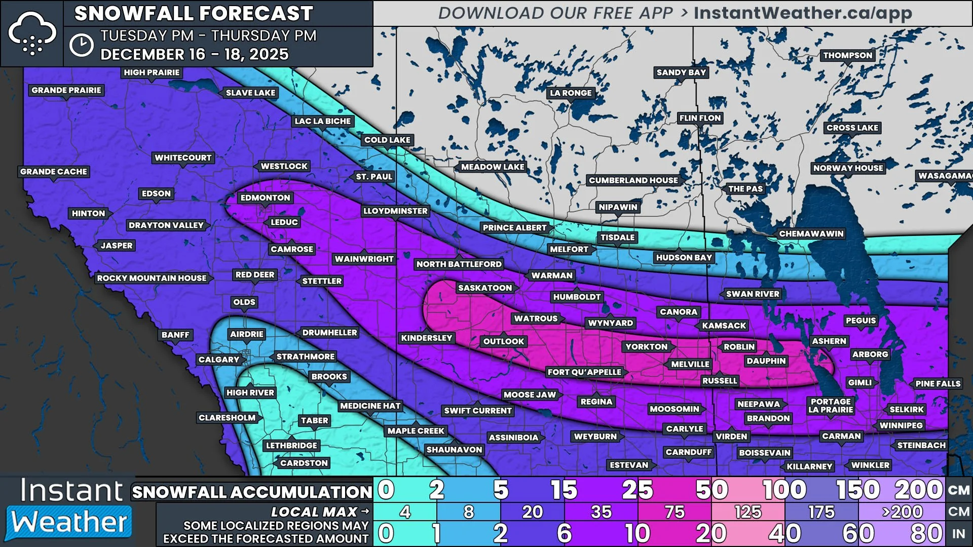
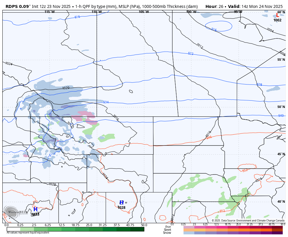
What previously looked like a possible widespread ice event, according to weather models, has luckily down-scaled and will now only impact a narrow track across parts of Saskatchewan and Manitoba.

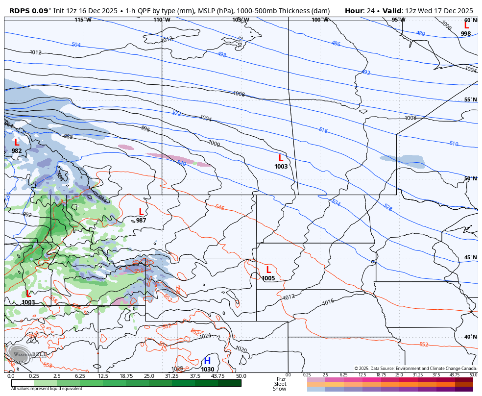
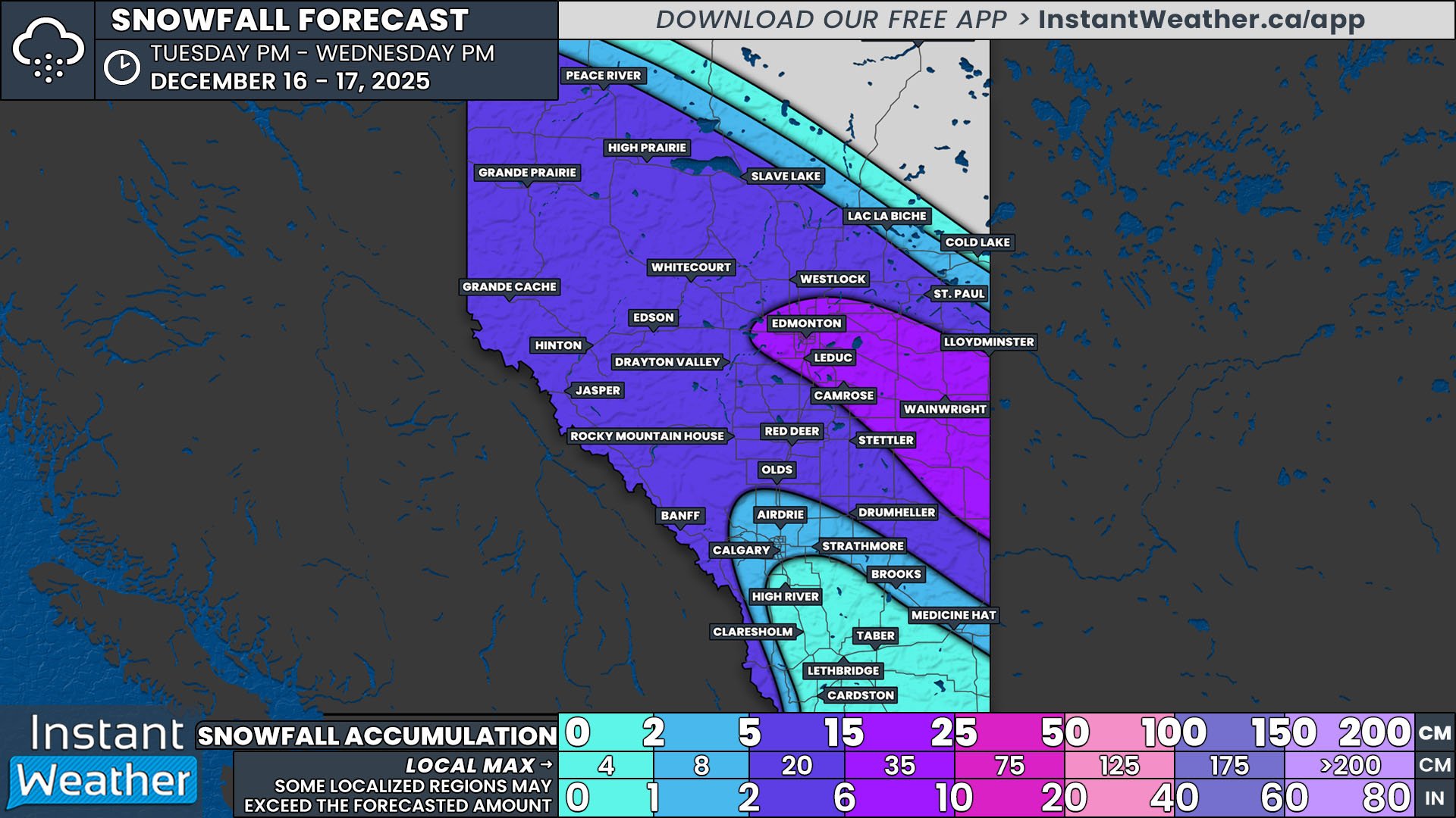
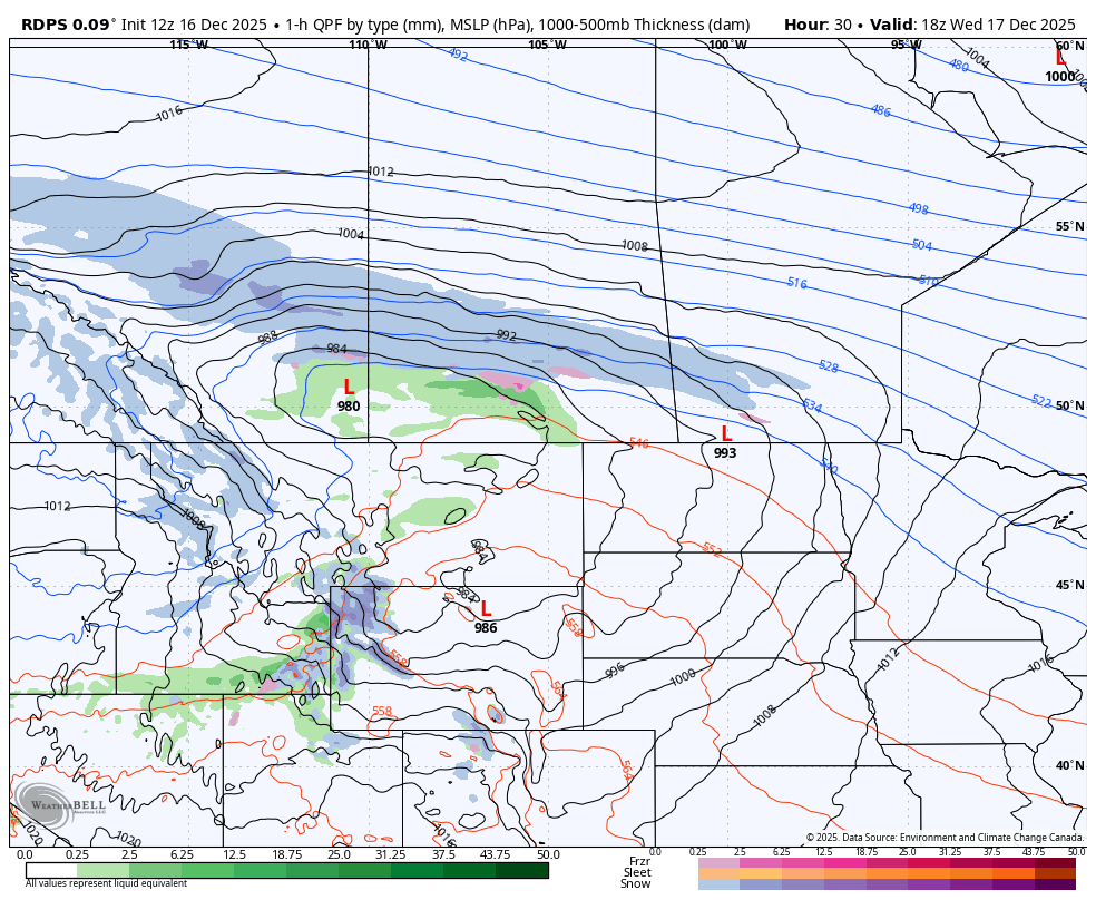
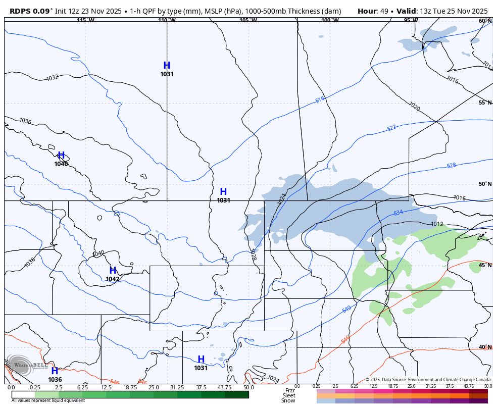
A disorganized system will cross into Southeast Saskatchewan from Montana after midnight tonight, travelling northeastward and reaching Manitoba shortly before sunrise. This system will only bring a narrow band of precipitation to the region, but due to the presence of warm air aloft and below freezing temperatures at the surface, this precipitation will fall as freezing rain. The freezing rain will be light and last for several hours, resulting in ice accretion amounts up to 5mm.


GOOGLE AD (NOT ENDORSED BY INSTANT WEATHER)

Temperature Profiles and Precipitation Types

By around the lunch hour, the freezing rain will start to taper off and transition over to snow. As the entire system pushes eastward, Southern Manitoba will also start to see some snow moving in from North Dakota Sunday afternoon. The system will become more organized throughout the evening and overnight, leading to the development of additional snow in Central and parts of Northern Manitoba. There is still some uncertainty regarding exact snowfall amounts, but it looks like the southern half of the province can expect 5-15cm of fresh snow by the end of Monday.

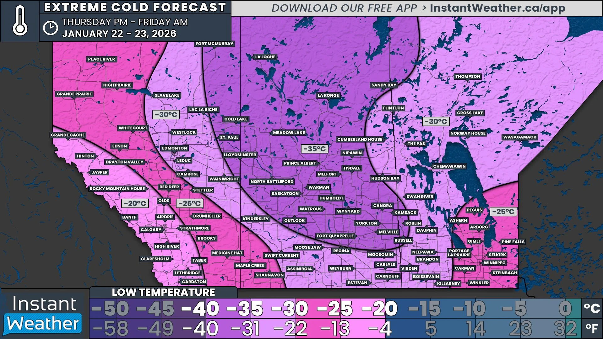
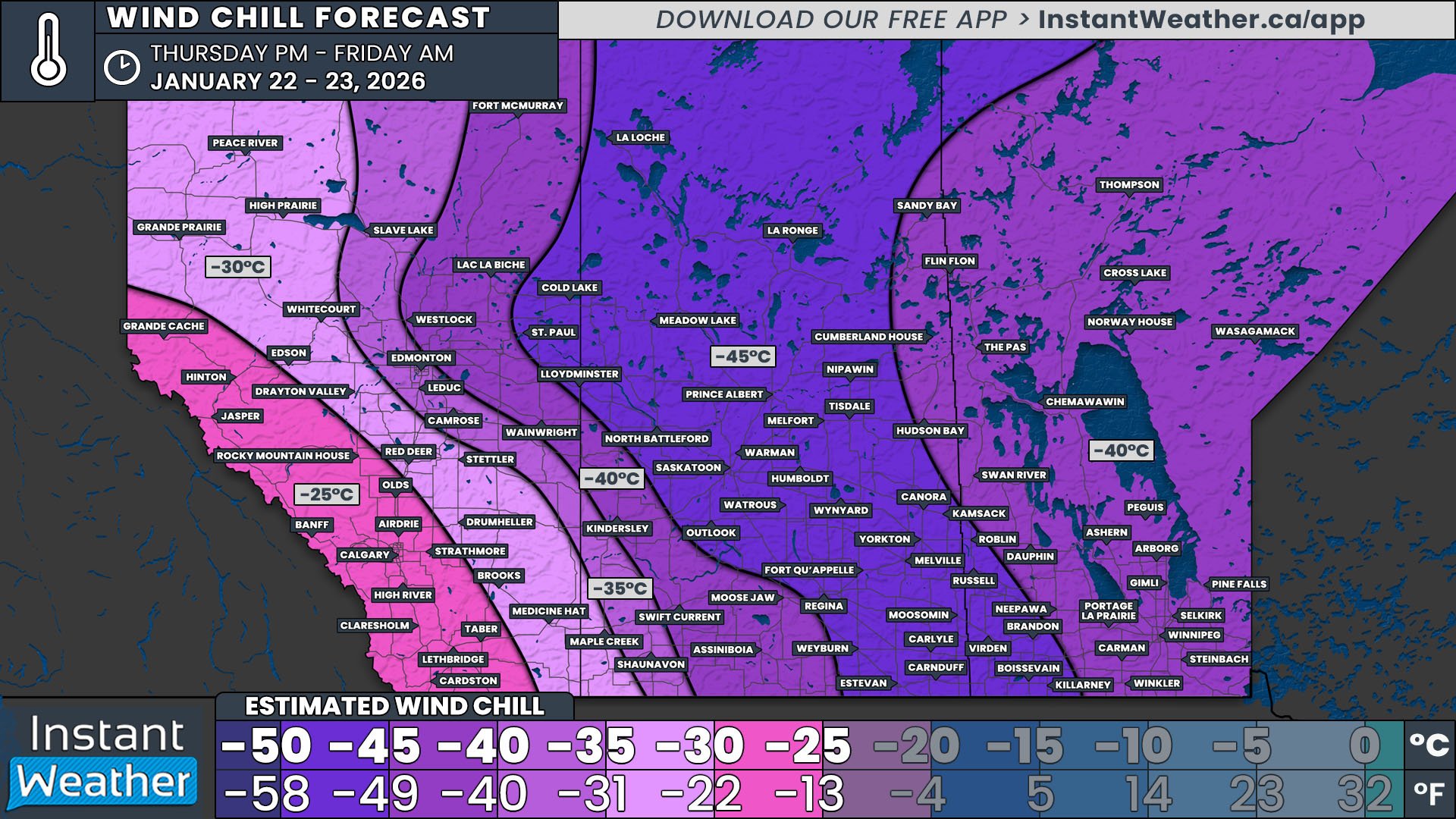
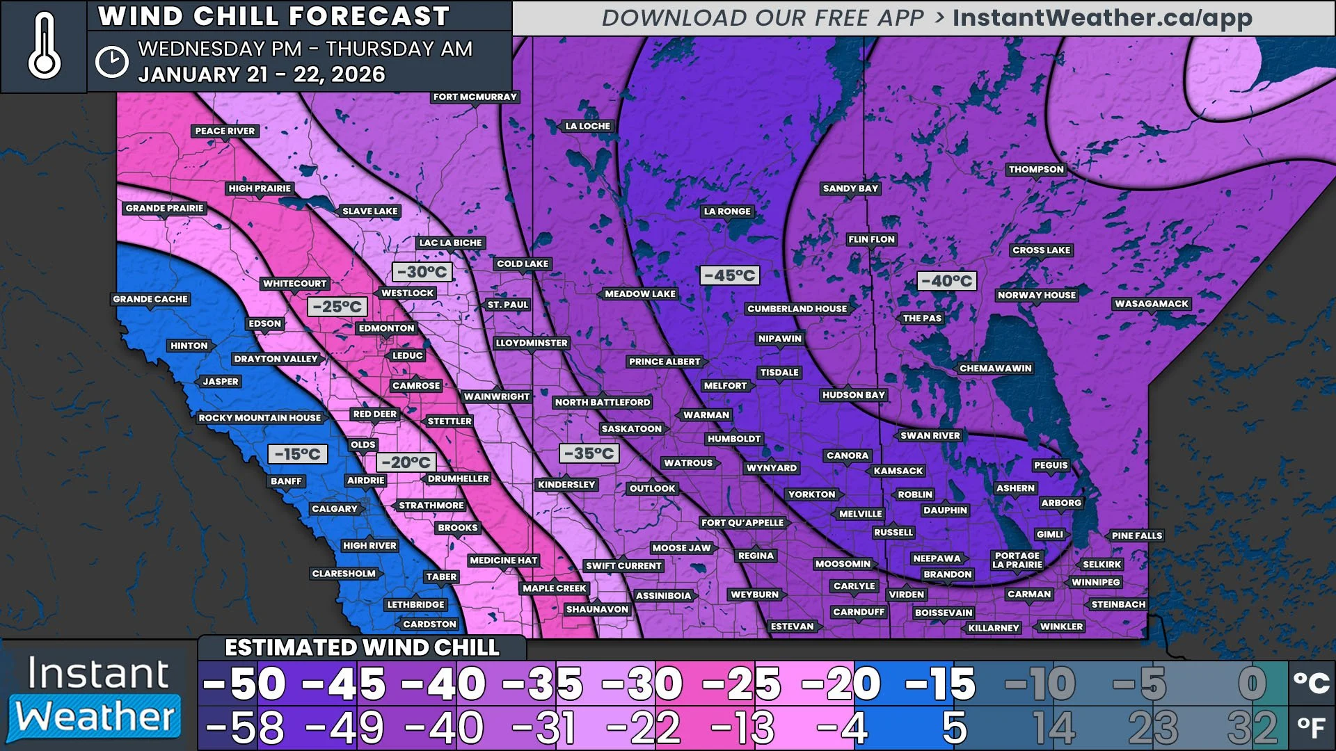
Widespread Temperatures Below -30°C and Windchills Approaching -45°C Have Prompted More Extreme Cold Warnings

NOTE: YOU CAN CLICK ON THE MAP TO OPEN A ZOOMABLE IMAGE


GOOGLE AD (NOT ENDORSED BY INSTANT WEATHER)

The extreme cold continues across Saskatchewan and Manitoba overnight tonight and through to tomorrow morning. Unfortunately, it will be colder than this morning, and a much larger area can expect temperatures below -30°C to settle in after midnight and continue until the late morning.

This intense cold poses a risk to everyone, especially young children, the elderly, individuals with chronic illnesses, outdoor workers, and those without adequate shelter. Symptoms of cold exposure, such as shortness of breath, chest pain, muscle pain and weakness, numbness, and colour change in fingers and toes, should be monitored closely.


GOOGLE AD (NOT ENDORSED BY INSTANT WEATHER)

The winds are expected be light again, at around 10-15km/h, as the temperatures reach their lowest point. With the even colder air than this morning, these light winds are going to result in windchills that are approaching -45°C. The coldest windchills are expected in the Westman Region, but windchills below -40°C will still be felt over a significant area. As a result, Environment Canada has issued more widespread Extreme Cold Warnings than last night, stretching from Saskatoon and into Northern Ontario.

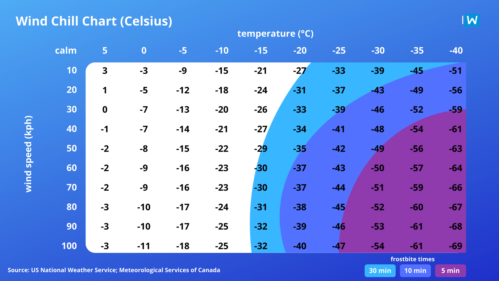
At these temperatures, frostbite can occur in as little as 30 minutes, and in some areas close to 10 minutes, so it is crucial to cover up when going out and limiting exposure all together. It’s also wise to keep emergency supplies in your vehicle, including extra blankets and jumper cables, in case of an emergency.


GOOGLE AD (NOT ENDORSED BY INSTANT WEATHER)

Extreme Cold Makes Its First Appearance of December With Windchills Dipping Below -40°C

NOTE: YOU CAN CLICK ON THE MAP TO OPEN A ZOOMABLE IMAGE

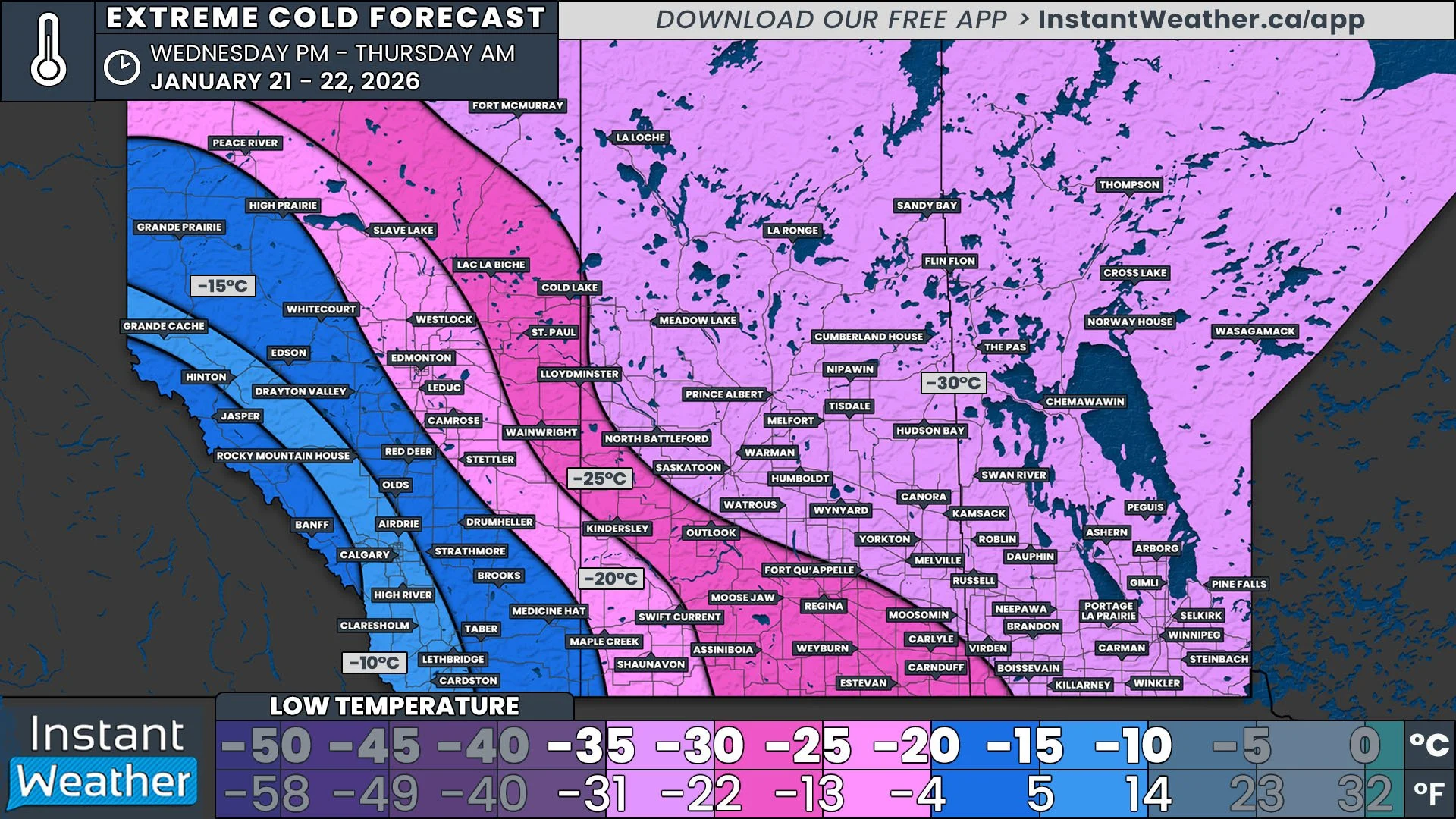
The extreme cold has returned to the Prairies with temperatures dipping below -20°C across a majority of Saskatchewan and Manitoba, with the exception of the Southwest Corner of Saskatchewan. Temperatures will be lower than -30°C in parts of Central Saskatchewan and into the Parkland Region of Manitoba. The cold Arctic air pushed south throughout the day today and temperatures will continue to fall overnight before reaching their lowest point in the mid-morning.

This intense cold poses a risk to everyone, especially young children, the elderly, individuals with chronic illnesses, outdoor workers, and those without adequate shelter. Symptoms of cold exposure, such as shortness of breath, chest pain, muscle pain and weakness, numbness, and colour change in fingers and toes, should be monitored closely.

Winds overnight tonight are expected be light, at around 10-15km/h. These light winds will easily push the windchill below -40°C, which has prompted Environment Canada to issue Extreme Cold Warnings for parts of both provinces.

At these temperatures, frostbite can occur in as little as 30 minutes so it is crucial to cover up when going out and limiting exposure all together. It’s also wise to keep emergency supplies in your vehicle, including extra blankets and jumper cables, in case of an emergency.


GOOGLE AD (NOT ENDORSED BY INSTANT WEATHER)

Messy Weekend Clipper Expected to Bring Widespread 10-20cm of Snow and Risk of Freezing Rain to the Prairies

NOTE: YOU CAN CLICK ON THE MAP TO OPEN A ZOOMABLE IMAGE

It’s going to be a messy weekend across the Prairies with a Clipper expected to bring over 10cm of snow in a swath from Edmonton, through Saskatoon, to Winnipeg. This will be the first considerable snowfall of the season for the Winnipeg area, which has lagged behind the rest of the Prairie provinces by a couple of weeks.

The snow won’t be the only concern from this storm; there will be the risk of freezing rain across the region in pockets where temperatures will climb a degree or two above freezing. On top of the snow and freezing rain, some areas will also see rain from this storm, making for a mixed bag of a weekend!


GOOGLE AD (NOT ENDORSED BY INSTANT WEATHER)

Alberta

Our Clipper will start to make its way into Alberta in the Northern Rockies as a disorganized mess of rain, snow, and mixed precipitation mid-morning Saturday. Temperatures are expected to climb above freezing across much of Southern and Central Alberta so as the system pushes eastward into the province through the afternoon, the precipitation should fall as rain.

Things become much more organized in the evening and as temperatures start to fall, most of the rain in Central Alberta will switch over to snow. There will be the risk of brief freezing rain during this transition which could make surfaces quite icy before being covered with snow. With the organization of the storm, snowfall rates will increase and snow accumulations above 10cm should start around Edmonton and continue east-southeastward along the track of the storm.

As the system starts to exit the province early Sunday morning, some precipitation will actually push into Southern Alberta. There will be brief freezing rain along the leading edge, bringing trace ice accretion to Red Deer and eastward, followed by some moderate snowfall that will lead to 5-10cm of snow to the area, including Medicine Hat. The snow will taper off in the west through Sunday morning, but it is expected to linger in the east through the day.


GOOGLE AD (NOT ENDORSED BY INSTANT WEATHER)

Saskatchewan

The storm will extend into Saskatchewan starting in the late afternoon or early evening on Saturday. With the temperatures in the single digits, it will start off as a narrow band of rain. As the temperatures fall later in the evening, however, we expect there to be a transition over to freezing rain that will last for several hours as the storm continues its path southeastward. There could be a considerable track of ice accretion of 2-5mm that stretches from Saskatoon through Moosomin and into Southwest Manitoba.

Unfortunately, the freezing rain will eventually transition to snow from west to east overnight, which will cover the frozen ground, making things even more slippery. This snow will be moderate to heavy at times, with snowfall rates up to 2cm per hour, resulting in snowfall totals of 10-20cm over a wide stretch of the province.

During early morning hours of Sunday, snow will start to wrap around from the west, bringing 5-10cm of snow to Southwest and West Central Saskatchewan and lesser amounts along the International border. The snow will start to dissipate Sunday afternoon before ending Monday morning in the southeast corner of the province.

NOTE: YOU CAN CLICK ON THE MAP TO OPEN A ZOOMABLE IMAGE

Manitoba

In a similar fashion to what is expected in Saskatchewan, as the Clipper crosses into Manitoba overnight Saturday, the leading edge will bring freezing rain into the province. This is only expected in the southwest corner of the province and the greatest ice accretion of 2-5mm will be found in an area that includes Virden and Boissevain.

After a few hours of freezing rain, the snow will follow and spread eastward across Manitoba through the morning. The storm will grow in size as the snow wraps around from the west in the early morning and the arrival of heavier snow in the afternoon will lead to a wider area receiving 10-20cm. The storm will start to push into Northern Ontario early Sunday afternoon and the snow will start to taper off overnight before eventually exiting the region by early Monday afternoon.

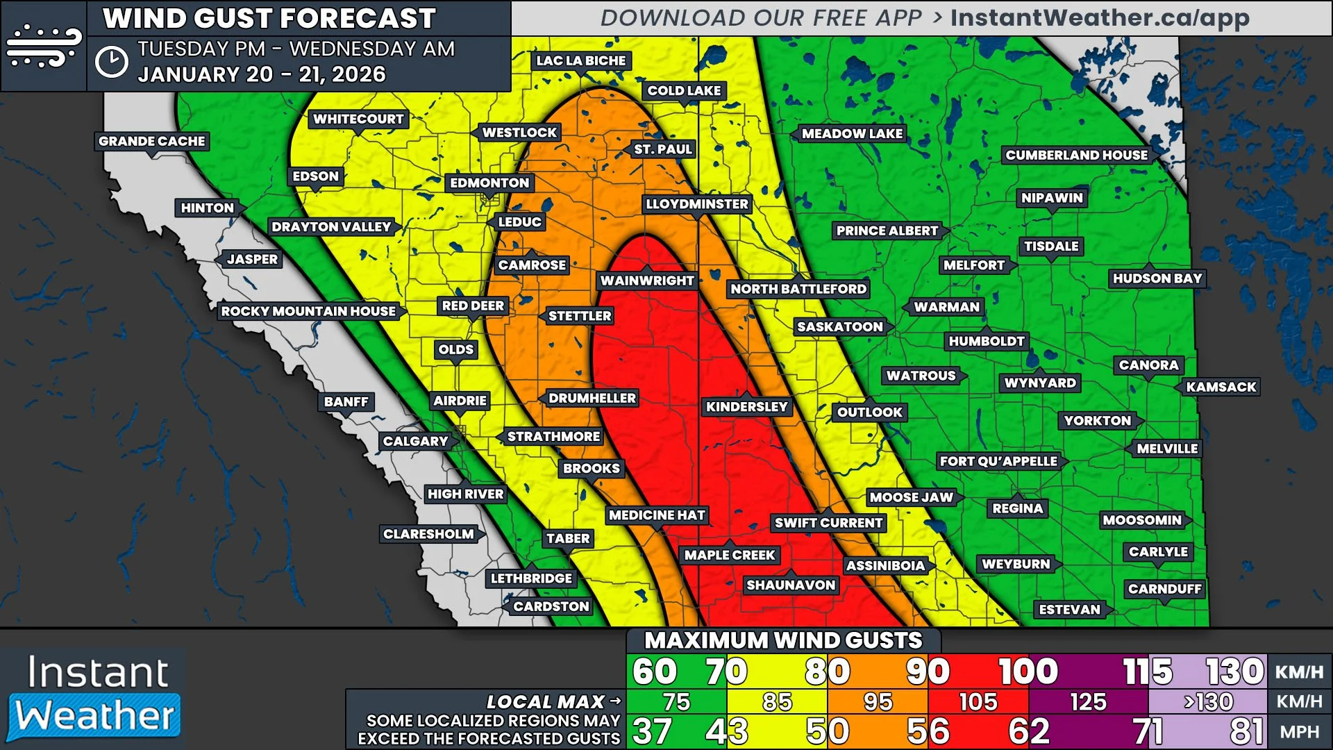
Widespread wind gusts of 50-70km/h are expected with the Clipper so on top of surfaces being quite icy over a wide area, blowing snow will be a concern As a result, we may see some highway closures throughout the duration of the storm. Road conditions will likely be very poor in the hardest hit areas so please take extra caution when travelling this weekend!

Another Night of Extreme Cold on Tap, Warnings Extend into Manitoba for Tonight as Windchills Reach -40°C Over a Wider Area

NOTE: YOU CAN CLICK ON THE MAP TO OPEN A ZOOMABLE IMAGE

The extreme cold continues across the Prairies with overnight lows dipping below -20°C across a large part of the region and lower than -30°C in Central Saskatchewan once again tonight and into tomorrow morning.

This intense cold poses a risk to everyone, especially young children, the elderly, individuals with chronic illnesses, outdoor workers, and those without adequate shelter. Symptoms of cold exposure, such as shortness of breath, chest pain, muscle pain and weakness, numbness, and colour change in fingers and toes, should be monitored closely.

Winds overnight tonight are expected to remain similar to last night, peaking at around 10-15km/h, but they are expected to be more widespread. These light winds will easily push the windchill below -40°C over a larger area, resulting in Environment Canada issuing more Extreme Cold Warnings for tonight.

At these temperatures, frostbite can occur in as little as 30 minutes so it is crucial to cover up when going out and limiting exposure all together. It’s also wise to keep emergency supplies in your vehicle, including extra blankets and jumper cables, in case of an emergency.

It appears that Saskatchewan and Manitoba could see a bit of a reprieve tomorrow night, with the coldest air expected to be found in Alberta instead.


GOOGLE AD (NOT ENDORSED BY INSTANT WEATHER)

First Extreme Cold Air of the Season to Settle Across the Prairies Over the Coming Days, Overnight Lows Dipping Below -30°C

NOTE: YOU CAN CLICK ON THE MAP TO OPEN A ZOOMABLE IMAGE

While it has been quite cool across the Prairies this week on the backside of last weekend’s storm, it’s about to get even colder over the next few days. The first of this extreme cold will be experienced overnight Thursday and Friday morning. A large swath of the Prairies will have overnight lows below -20°C tonight while parts of Central Saskatchewan will see temperatures dipping below -30°C, prompting the first Extreme Cold Warnings of the season from Environment Canada that includes Saskatoon.

This intense cold poses a risk to everyone, especially young children, the elderly, individuals with chronic illnesses, outdoor workers, and those without adequate shelter. Symptoms of cold exposure, such as shortness of breath, chest pain, muscle pain and weakness, numbness, and colour change in fingers and toes, should be monitored closely.

Winds overnight are expected to top out at around 10-15km/h and while this is just a light breeze, it’ll be enough to drive the windchill well below -40°C in the coldest areas. At these temperatures, frostbite can occur in as little as 30 minutes so it is crucial to cover up when going out and limiting exposure all together. It’s also wise to keep emergency supplies in your vehicle, including extra blankets and jumper cables, in case of an emergency.

We will continue to provide updates over the coming days as these cold temperatures persist.


GOOGLE AD (NOT ENDORSED BY INSTANT WEATHER)

Second Storm This Week Will Dump Even More Snow Across Saskatchewan & Manitoba This Weekend

NOTE: YOU CAN CLICK ON THE MAP TO OPEN A ZOOMABLE IMAGE

We hope you’ve kept your shovels handy following the storm earlier this week because there is even more snow on its way for Saskatchewan and Manitoba this weekend.

Thankfully this storm will be less complex than the previous one and the situation in two particular areas will be different this time around. The western edge of Saskatchewan, where next to no snow fell during the previous storm, is now in the crosshairs with more than 20cm of snow expected. Meanwhile, those in Winnipeg and the Eastman Region, who received drenching rains within the warm sector of the earlier storm, will finally see some snow, but overall accumulations will be limited.

Since last night’s preliminary forecast, model data has trended slightly to the north. This means that areas along the boundaries from the previous forecast could see either an increase or decrease in projected snowfall totals.


GOOGLE AD (NOT ENDORSED BY INSTANT WEATHER)

We’ve already seen a bit of light snow pushing its way into Southwest Saskatchewan from Alberta this afternoon and while this snowfall is associated with the expected storm, its a precursor band that will bring less than 5cm of snow to a small area that includes Maple Creek and Shaunavon.

The main event will begin Saturday morning, as the more organized band of snow pushes into Saskatchewan. It will start as light snow, but gradually intensify through the late morning and continuing overnight as the storm makes its way across the province. The heaviest snow is expected to fall mostly in Western Saskatchewan, leading to over 20cm of accumulation from Kindersley to Wynard by Sunday morning. At that point, there will only be some lingering light snow in Northern Saskatchewan that will continue into Monday morning.

The snow will remain steady as it crosses into Manitoba starting Saturday evening in the Westman Region and then the Parkland Region around midnight. The storm will begin to lose intensity by the time it moves into the Interlake Region on Sunday morning and as a result, there will be a decrease in snow accumulation down to 5-10cm, with only light snow falling for the remainder of the day. Since the storm will have a slight northeasterly trajectory as it crosses Manitoba, communities along the American border and into Winnipeg will see less than 5cm of snow fall.

The snow will begin to taper off Monday morning across Manitoba, with some scattered flurries continuing until late in the day, at which time the storm will exit the region.

One of the biggest challenges during the last storm was the blowing snow due to high winds. While the winds are not expected to be quite as intense this time around, gusts up to 50km/h could reduce visibility and result in some road closures, particularly through Southern Saskatchewan.

Another Snowstorm Could Dump Up to 30cm of Snow on Saskatchewan & Manitoba This Weekend

NOTE: YOU CAN CLICK ON THE MAP TO OPEN A ZOOMABLE IMAGE

As residents across parts of Saskatchewan and Manitoba begin digging out from the first significant snowfall of the season, another winter storm is already on the horizon.

Snowfall is expected to start in western Saskatchewan as early as Saturday morning, with the worst conditions anticipated over the weekend. By the time the system wraps up on Monday, widespread snow accumulation of 15 to 30 cm is likely.


GOOGLE AD (NOT ENDORSED BY INSTANT WEATHER)

Although current model data shows good consistency regarding the storm's intensity and track, it’s still over 24 hours away, and some slight adjustments are possible. Be sure to check back on Friday for our updated forecast, which will include more precise snowfall accumulation predictions.

A teaser of what’s to come will arrive on Friday as light snow begins moving into southwestern Saskatchewan during the afternoon. This snowfall isn’t expected to spread far across the province and should mostly fizzle out by Saturday morning. Areas like Maple Creek and Shaunavon could see a few centimeters of accumulation, possibly up to 5 cm.


GOOGLE AD (NOT ENDORSED BY INSTANT WEATHER)

However, the break in snowfall will be brief, as another wave of precipitation sweeps into the province from Alberta. This system will begin as light snow late Saturday morning, gradually increasing in intensity throughout the afternoon.

By the evening, snowfall will have reached Saskatoon and Regina, with moderate to heavy snow spreading across much of Saskatchewan. The worst conditions are expected overnight into Sunday morning, when snowfall rates will peak.

Blowing snow could also pose a concern, with wind gusts of 40-50 km/h reducing visibility on roads. While conditions aren’t expected to meet blizzard criteria, drivers should anticipate poor travel conditions and potential highway closures beginning Saturday evening, particularly in western Saskatchewan. Road conditions will likely remain hazardous until Sunday afternoon, starting with improvements in the western parts of the province.


GOOGLE AD (NOT ENDORSED BY INSTANT WEATHER)

By the early hours of Sunday, snowfall will have reached western Manitoba, with its intensity ramping up through the morning. Current forecasts suggest the heaviest snowfall will target central portions of western Manitoba, including the Interlake region.

Brandon is expected to see snow begin late Sunday morning, with light to moderate snowfall continuing throughout the day. Winnipeg will likely see snow begin in the early afternoon, continuing into the evening and overnight hours.

Snowfall will gradually taper off by Monday morning, with lingering flurries in central parts of Saskatchewan and Manitoba.


GOOGLE AD (NOT ENDORSED BY INSTANT WEATHER)

The storm is expected to lose some intensity as it progresses eastward across the Prairies. This means the highest snowfall totals will likely occur in western and central Saskatchewan. Snowfall amounts of 20-30 cm are expected in these areas by Monday morning, with localized pockets exceeding 30 cm. Locations such as Swift Current, Moose Jaw, Regina, and Kindersley are within this high-impact zone.

For the rest of Saskatchewan, snowfall amounts are forecast to range between 5 and 15 cm, with some areas potentially nearing 20 cm depending on the storm’s exact track. We’ve opted for a general forecast of "up to 20 cm" for now but expect refinements in our final update.

In Manitoba, western regions—including areas already hit hard by the earlier storm this week—can expect 10-15 cm, with isolated totals approaching 20 cm. Areas east of Brandon, including Winnipeg, are forecast to see lighter accumulations of 5-10 cm. Snowfall totals will taper off further north, with minimal impacts expected in northern Manitoba.


GOOGLE AD (NOT ENDORSED BY INSTANT WEATHER)

ESTIMATED WIND CHILL ON SATURDAY MORNING - MAP FROM WEATHERBELL

One significant difference between this storm and the one earlier this week is the temperature. This event will be accompanied by much colder air, meaning it will produce all snow, with no risk of mixed precipitation. Additionally, colder temperatures will result in higher snowfall ratios, so it won’t take much liquid precipitation to produce substantial snowfall amounts.


GOOGLE AD (NOT ENDORSED BY INSTANT WEATHER)

This colder air also brings added risks for anyone traveling during the storm. Extremely cold wind chills are expected to develop as early as Saturday, with some areas feeling like the -20s across Saskatchewan and into Manitoba. If you get stranded on the roads, staying warm may be difficult, so it’s highly recommended to avoid travel during this storm.

First Major Winter Storm of the Year Will Bring Up to 50cm of Snow and Blizzard Conditions to Saskatchewan & Manitoba

NOTE: YOU CAN CLICK ON THE MAP TO OPEN A ZOOMABLE IMAGE

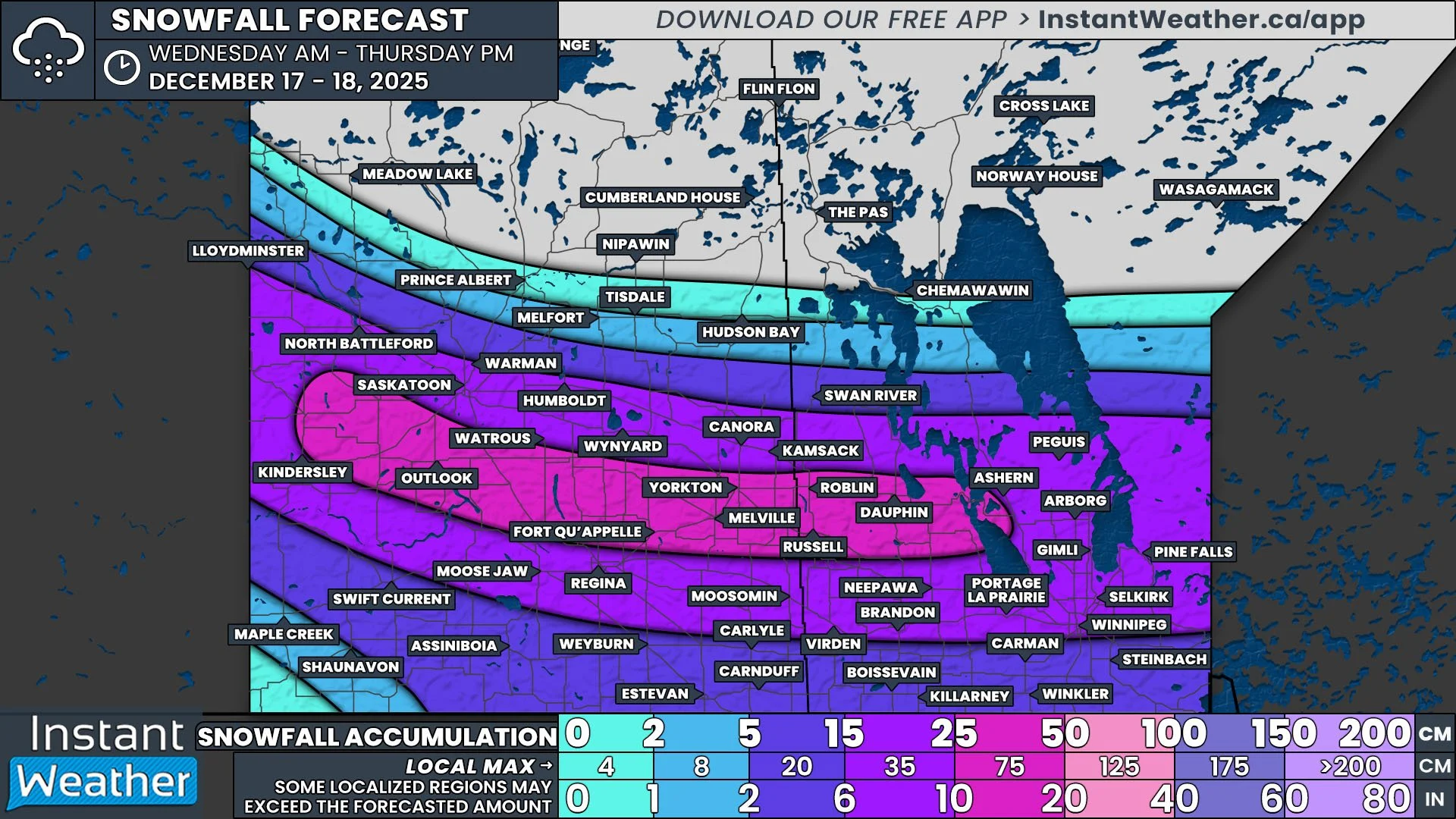
The first major winter storm of the season for the Prairies is here, with rain already falling in Southeast Saskatchewan along with pockets of freezing rain and snow. In last night’s preliminary forecast, we discussed the complexity of this multi-day storm and now that the storm is on our doorstep, there is more confidence in the forecast. Some areas of Central and Northern Saskatchewan and into Northern Manitoba could now see upwards of 50cm by the end of Wednesday, with blizzard conditions possible in the south.


GOOGLE AD (NOT ENDORSED BY INSTANT WEATHER)


As mentioned above, the first round of precipitation from this event has already made its way into Saskatchewan this afternoon. Rain is falling in Southeast and East Central Saskatchewan and there is snow further north, in the Hudson Bay area. The rain will transition over to snow as we progress through the evening with the heaviest snow expected to fall east of Prince Albert, from Melfort through to Cumberland House, starting later in the evening and continuing straight through to Wednesday morning.

As this band of precipitation pushes eastward into Manitoba overnight and into the early morning hours of Tuesday, it will encounter a strong low pressure system coming north out of the States. This incoming system from the south will bring steady rain, that is heavy at times, to Southern Manitoba throughout Tuesday morning. When the two systems meet, they will merge to form one large storm and by late Tuesday morning, cooler air will be pulled towards the centre of the storm from Northern Saskatchewan, leading to a transition of rain to snow with a brief period of freezing rain in the Westman Region.

By Tuesday afternoon, the snow will start to ease in Saskatchewan, but snowfall rates in Manitoba, on the other hand, will increase, leading to quick accumulations of snow. It’s at this point that the winds will start to pick up. Sustained winds of 40km/h and gusts exceeding 70km/h, combined with the heavy snowfall, will likely lead to blowing snow and blizzard conditions overnight Tuesday through to Wednesday morning.

This storm will finally diminish Wednesday afternoon, leading to a gradual tapering off of snow throughout the region.

‘Blizzard Conditions Possible’; Winter Storm Could Dump Up to 30cm of Snow on Parts of Saskatchewan and Manitoba Early This Week

NOTE: YOU CAN CLICK ON THE MAP TO OPEN A ZOOMABLE IMAGE

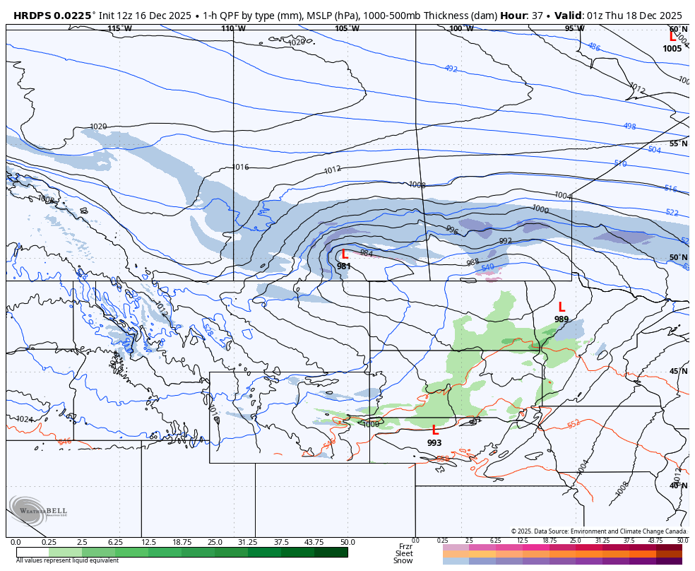
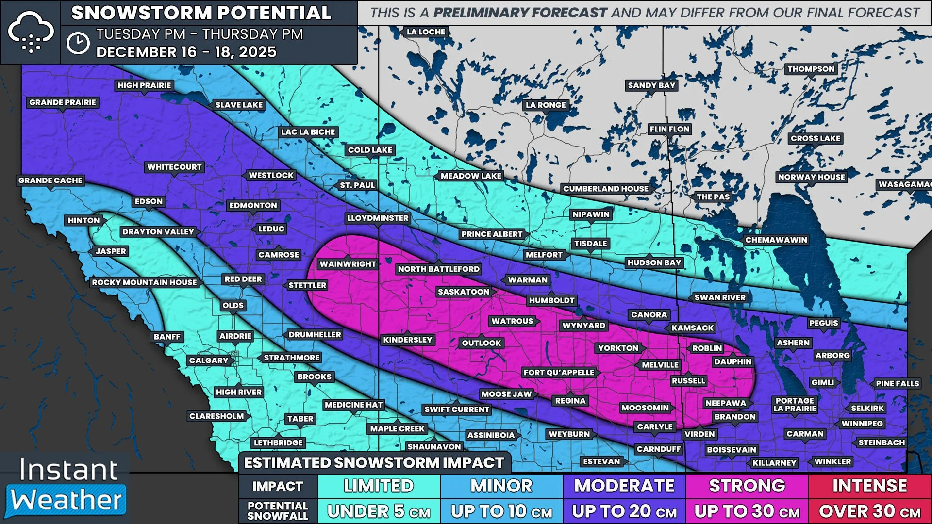
Mother Nature isn’t holding back as a powerful winter storm sets its sights on Saskatchewan and Manitoba, starting late Monday. This storm will bring heavy snow, strong winds, and even blizzard conditions, marking the region’s first significant taste of winter. Some areas in Eastern Saskatchewan and Western Manitoba could see up to 30 cm of snow, with localized amounts possibly exceeding that by the end of Wednesday.


GOOGLE AD (NOT ENDORSED BY INSTANT WEATHER)

Sustained winds of 40 km/h, with gusts reaching 70–80 km/h, are expected to create blowing snow, particularly overnight Tuesday into Wednesday morning. Blizzard conditions could develop in some areas. Prepare for hazardous travel, as highway closures are likely in the hardest-hit regions.

Before diving into the details, it’s important to note that this is a complex storm, with snowfall accumulating over multiple days. This preliminary forecast provides a general idea of the storm’s potential impacts, but adjustments are likely as the system approaches. Stay tuned for updates, including a more detailed snowfall accumulation map in the coming days.


GOOGLE AD (NOT ENDORSED BY INSTANT WEATHER)

PRECIPITATION TYPE - MAP FROM WEATHERBELL

The storm will begin in Saskatchewan late Monday afternoon or evening, as precipitation moves into the province from the south. The first round of snowfall will primarily impact Central and Northeastern Saskatchewan, with areas like Prince Albert and Nipawin expected to see the heaviest snow through late Monday.

Overnight Monday into early Tuesday, precipitation in Saskatchewan will merge with an approaching system from the south, targeting Manitoba. The exact track of this system remains uncertain, but it’s expected to bring significant precipitation to Manitoba throughout Tuesday.


GOOGLE AD (NOT ENDORSED BY INSTANT WEATHER)

PRECIPITATION TYPE - MAP FROM WEATHERBELL

Initially, much of Eastern Manitoba, including Winnipeg, will see heavy rain. By Tuesday late morning or early afternoon, colder air will begin to wrap into the region, creating a risk of freezing rain in parts of Southwestern Manitoba, including Brandon and Portage la Prairie.

Meanwhile, heavy snow will persist across Eastern Saskatchewan, where Arctic air is firmly in place. There is some uncertainty about how far west the precipitation will extend into Saskatchewan, but the heaviest snow is expected closer to the Manitoba border.


GOOGLE AD (NOT ENDORSED BY INSTANT WEATHER)

PRECIPITATION TYPE - MAP FROM WEATHERBELL

By Tuesday late afternoon, most of Manitoba will transition from rain to snow as colder air overtakes above-freezing temperatures. Heavy snow will continue through the overnight hours into Wednesday morning.


GOOGLE AD (NOT ENDORSED BY INSTANT WEATHER)

SUSTAINED WIND SPEED - MAP FROM WEATHERBELL

Strong winds, with sustained speeds near 40 km/h and gusts of up to 70 km/h, will develop late Tuesday and persist into much of Wednesday. Combined with heavy snowfall, this will likely lead to blowing snow and blizzard-like conditions, particularly in parts of Eastern Saskatchewan and Western Manitoba.

As the system exits the region later on Wednesday, the snowfall will gradually taper off. However, this storm will usher in the coldest air of the season so far, with temperatures dropping to -10°C to -20°C by the end of the week.


GOOGLE AD (NOT ENDORSED BY INSTANT WEATHER)

Snowfall Accumulation

NOTE: YOU CAN CLICK ON THE MAP TO OPEN A ZOOMABLE IMAGE

Monday

By the end of Monday, snowfall totals are expected to reach 5–10 cm in parts of Central and Eastern Saskatchewan, including Prince Albert, Melfort, and Tisdale. Surrounding areas, such as Saskatoon and Wynyard, could see up to 5 cm of snow.


GOOGLE AD (NOT ENDORSED BY INSTANT WEATHER)

NOTE: YOU CAN CLICK ON THE MAP TO OPEN A ZOOMABLE IMAGE

Tuesday and Wednesday

From Tuesday through Wednesday, snowfall totals are expected to range between 15 and 30 cm across much of the affected region. The heaviest accumulations are anticipated near the Saskatchewan–Manitoba border, where localized totals could exceed 30 cm. Elevation will play a significant role, especially in Western Manitoba, where areas of higher terrain could see as much as 30–40 cm.


GOOGLE AD (NOT ENDORSED BY INSTANT WEATHER)

In Central and Eastern Manitoba, snowfall amounts are harder to pinpoint, as the transition from rain to snow will dictate final totals. Portage la Prairie could see 15–25 cm, while Winnipeg may only receive 10–15 cm, depending on how long the rain lingers before changing to snow.

A similar uncertainty exists in Saskatchewan, but for a different reason—how far west the moisture will penetrate into the province. Some forecasts keep the heaviest precipitation closer to the Manitoba border, while others push it further west. Regina sits on the edge of the higher accumulation zone, with current estimates suggesting 5–15 cm for the city and surrounding areas.

Snowy Weekend Ahead for Parts of Southern Saskatchewan and Manitoba With Up to 20cm Possible

NOTE: YOU CAN CLICK ON THE MAP TO OPEN A ZOOMABLE IMAGE

It was only a matter of time before the first significant snowfall hit Southern Saskatchewan and Manitoba and a system moving northward from the States will deliver that.


GOOGLE AD (NOT ENDORSED BY INSTANT WEATHER)

The precipitation will cross the border shortly after midnight tonight as it travels northeastward into Southeast Saskatchewan. This precipitation will be split between snow to the west and a pocket of rain to the east in the extreme Southeast corner of Saskatchewan as a result of a difference in temperature; below freezing in the west and positive single digits to the east. The temperature gradient will persist throughout the event and will result in areas of Western Manitoba seeing a brief period of light rain before temperatures drop and there is a transition to snow as the precipitation spreads.

The rain will be short-lived in Saskatchewan as the system pushes further into the region and cross into Manitoba by the mid-morning. At this point, the snowfall over Southeast Saskatchewan is expected to intensify, leading to widespread 5-10cm of accumulation in that area and into the Parkland region of Manitoba. A smaller area, that includes Carlyle, Estevan, Moosomin, Weyburn, and Dauphin can expect upwards of 20cm of snow as a result of this intensification through the afternoon.

By the mid-afternoon, the area of rain will start to expand eastward across the rest of Southern Manitoba, which will limit the amount of snowfall in Portage la Prairie and the Interlake Region. As the system continues to move across the region through the evening and overnight, a widespread 5-10mm of rain will fall across Southeast Manitoba.

The snow is expected to finish in Saskatchewan by midnight Saturday and the mix of precipitation will continue throughout Southern Manitoba until early Sunday afternoon. With the transition from rain to snow in some areas and a quick blast of up to 20cm of snow in others, road conditions will likely be poor so take extra care when travelling, particularly on Saturday.

What's in a Name? Choosing the Right Tires to Drive you Through Canadian Winters

Tread patterns of summer, all season and winter tires. Image courtesy of discount tire.

Now that it’s the first week of November, many Canadians are starting to think about putting winter tires on their vehicles. There have been pockets of unseasonable warmth across the country in October and the start of November, the inevitable chill of winter is in the air, and many have already seen snow fall.

While winter tires are recommended throughout the country, they are mandatory in Quebec from December 1st to March 15th, and from October 1st to April 30th on certain British Columbia highways. Additionally, studded tires are allowed almost nationwide, with the exception of residents of Southern Ontario.

Insurance companies across the country offer discounts for installing winter tires as an incentive to encourage drivers to reduce the risk of accidents. So what makes winter tires that much better in the cold and snow than summer tires and where do all season and all weather tires fit into the mix?


GOOGLE AD (NOT ENDORSED BY INSTANT WEATHER)

With the right tools, it can be pretty easy to change your own tires!

Summer Tires

Summer tires are designed to handle both wet and dry road conditions with their wide tread and soft rubber. These tires also usually have deeper grooves that improve traction on wet roads and reduce hydroplaning, making them ideal for the wet spring and summer months.

Winter Tires

Like their name suggests, winter tires have been designed for winter roads. They are made with rubber that stays flexible at temperatures below 7°C (45°F), the magic number at which other tires become stiff and lose traction, greatly reducing their performance. Furthermore, winter tires have different tread patterns that are meant to divert water and slush to the sides, as well as little slits called sipes that increase the overall grip of the tires and helping them maintain contact with icy road surfaces. Over the past several years, tire manufacturers have started to include additional small particles, like crushed glass or walnut shells, that act as little studs on the surface of the tire for extra grip.


Performance of All Season Tires vs Winter Tires with decreasing temperatures. Image courtesy of Discount Tire.

All Season & All Weather Tires

Some people argue that winter tires aren’t necessary if they have all season tires on their vehicle. Unfortunately, this is a slight misnomer because while these tires can handle a bit of cold and snow, they fail to handle heavier snowfalls that are common in Canadian winters. All season tires, unfortunately, sacrifice traction in wet conditions that would be found in summer tires and some of the flexibility and grip seen with winter tires in order for the tread to last longer. Realistically, these should be called 3 season tires as opposed to all season. So while they’re not the best option for winter driving in Canada, all season tires are definitely a better choice than regular summer tires.

All weather tires, not to be confused with all season tires, are a true year-round tire designed to handle Canadian winters. Unlike all season tires, these tires remain soft and flexible well below 7°C. The tread pattern on all weather tires is a combination of all season and winter tires, making them better suited for driving through heavier snow than all season tires. While they still don’t match the performance of a true winter tire, all weather tires are the best option for those who don’t want the hassle of swapping out their tires twice per year or simply do not have the space to store an extra set. Their versatility truly makes all weather tires a middle of the road tire (pun intended) for Canadian drivers.


The three-peak mountain snowflake symbol found on winter and all weather tires. Image courtesy of Canadian tire.

When looking for tires to get you through the winter, it is recommended to chose either a proper winter tire or an all weather tire, so long as it has the three-peak mountain and snowflake symbol on the sidewall. This is an industry standard symbol which indicates that the tire meets strict regulations for winter performance; becoming mandatory on all winter tires beginning in 2018, transitioning away from just using the M+S (Mud and Snow) designation.


Further Reading

https://www.canadiantire.ca/en/how-to/automotive/how-to-choose-winter-tires.html

https://www.continental-tires.com/ca/en/tire-knowledge/winter-tire-laws-in-canada/

https://www.continental-tires.com/ca/en/tire-knowledge/winter-tire-markings/

https://www.discounttire.com/learn/tires-below-45

https://www.discounttire.com/learn/winter-summer-allseason

Note: The author formerly received payments from “Big Tire” however, this article was not funded.

Update: Wintry Mix Continues, Pocket of Sub-Freezing Temperatures to Increase Snowfall Totals Tuesday

NOTE: YOU CAN CLICK ON THE MAP TO OPEN A ZOOMABLE IMAGE

It’s been a messy start to the week across parts of Alberta and into Southern Saskatchewan, with a low pressure system bringing mixed precipitation to the region today. This storm has been progressing as expected so far, but the latest data from weather models has resulted in some slight revisions to our forecast for Tuesday.


GOOGLE AD (NOT ENDORSED BY INSTANT WEATHER)

Throughout the day Monday, we’ve seen temperatures above freezing across most of Southern and Central Alberta, resulting in precipitation falling as a rain-snow mix, and limiting overall snowfall accumulations. The exception to this has been in the Grande Cache area, where the temperatures have remained below 0°C and the precipitation has fallen as snow.

The single digit temperatures will continue overnight across most of Southern Alberta and Saskatchewan, but with being only being a degree or two above, or even at, freezing, we expect there to be a bit more snow accumulating beginning in the early morning hours Tuesday. This has been reflected by an increase in the forecasted snowfall for Taber, Brooks and north towards Strathmore and Drumheller.

As the temperatures begin to climb after sunrise, we will see the transition back to a rain-snow mix across the region. However, there is a small pocket where sub-zero temperatures will persist throughout the day, particularly in Medicine Hat, Maple Creek and the surrounding area. Steady snowfall will increase accumulations amounts to 5-10cm with locally higher amounts of up to 15cm possible in this area by the end of the day.

It is also expected that the precipitation from this system will push further eastward into Saskatchewan Tuesday afternoon and evening. By the late afternoon Tuesday, Arctic air will flood into the Prairies so the remaining light precipitation in Southern Saskatchewan at that point will fall as snow. As a result, we have extended the area covered by the 2-5cm range to include Outlook, Moose Jaw, and Assiniboia. Meanwhile, Saskatoon, Watrous, Fort Qu’Appelle, Estevan, and areas in between can now expect trace amounts (less than 2cm) of snow. The snow will diminish overnight, but scattered light flurries are possible in Southeast Saskatchewan Wednesday morning.

Messy Wintry Mix to Impact Alberta & Saskatchewan for the First Week of November

NOTE: YOU CAN CLICK ON THE MAP TO OPEN A ZOOMABLE IMAGE

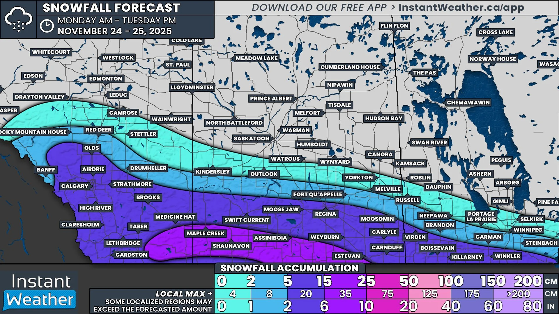
The first week of November is going to have an active and messy start across Southern Alberta and Saskatchewan. The arrival of a low pressure system will bring widespread precipitation Monday and Tuesday, but the dominant type of precipitation that falls will vary throughout the region.


GOOGLE AD (NOT ENDORSED BY INSTANT WEATHER)

The low pressure centre will cross into Alberta Monday morning in the Grande Cache area, bringing steady light snow to the area. As the low gradually travels southeastward across the province throughout the day and overnight, the precipitation will follow and spread across much of Central and Southern Alberta and continue for most of the day Tuesday. The low will move into Saskatchewan by early Tuesday morning, bringing precipitation to the southwest region of the province throughout the morning and into the late evening before dissipating.

The exact snowfall accumulation across Alberta and Saskatchewan from this system has been tough to forecast, with temperatures in the single digits for a large part of the region, meaning that the precipitation will fall as a mixture of rain and snow. This, combined with still mild ground temperature, should greatly reduce overall snow accumulations. As a result, we’ve gone with a more conservative snowfall forecast. The areas with the greatest snowfall potential, and the least mixing, will be found to the west of the low pressure system, behind its associated cold front and in the area with the coolest air, namely in the Grande Cache area and through the Rockies.
Trick-or-Treat: A Potential Spooky ‘Headless’ Comet Could Be Visible Across Canada Around Halloween

It's been a spectacular year for skywatchers across Canada, with events like solar eclipses, supermoons, and vibrant northern lights lighting up the night. Now, it looks like we might be in for another treat—a "headless" comet could make an appearance just in time for Halloween.


GOOGLE AD (NOT ENDORSED BY INSTANT WEATHER)

October seems to be the month of comets, with Comet Tsuchinshan-ATLAS gracing the early evening skies recently. Many stargazers caught glimpses of the comet, which was visible in the western sky just after sunset. Although it has since faded from naked-eye visibility, you can still catch it with a telescope, and it will remain somewhat visible into early November.

But the cosmic show isn’t over yet. A second comet, called Comet ATLAS (C/2024 S1), may arrive just in time for Halloween, and it comes with a spooky twist—it could appear "headless." The comet’s name might sound familiar because it was discovered by the same ATLAS asteroid tracking system, known for spotting objects that could potentially impact Earth.


GOOGLE AD (NOT ENDORSED BY INSTANT WEATHER)

The main difference between this upcoming comet and the earlier one lies in its path. While the first comet passed safely between Earth and the Sun, around 40 million miles from the Sun, this new comet will come much closer, potentially within 700,000 miles of the Sun's surface. Because of this close approach, scientists predict that the comet’s head—its bright core—might disintegrate due to the Sun's intense heat, leaving just a faint, trailing tail visible from Earth.

To understand what makes a comet appear "headless," it's important to know a bit about its structure. Comets are made up of a nucleus, or core, composed of rock, dust, and frozen gases. When they approach the Sun, the heat causes the frozen gases to vaporize, forming a glowing coma around the nucleus and a tail that extends away from the Sun. If the nucleus disintegrates, the glowing head might vanish, leaving behind only a ghostly tail, hence the term "headless comet."


GOOGLE AD (NOT ENDORSED BY INSTANT WEATHER)

ESTIMATED BRIGHTNESS OF COMET - SOURCE: sKYWALK.SPACE

The exact visibility of this comet remains uncertain. It will come closest to Earth on October 24th as it travels toward the Sun, reaching its closest point to the Sun, known as perihelion, on October 28th. There’s even a chance it could be bright enough to see during the day, potentially appearing as bright as Venus from 7:12 AM to 8:06 AM (ET) in the east-southeastern sky.

However, those in the Northern Hemisphere may struggle to spot it due to its position low in the sky near the Sun, making it difficult to see without obstruction from sunlight or clouds.


GOOGLE AD (NOT ENDORSED BY INSTANT WEATHER)

NASA offers some tips for spotting the comet during this close approach. To view it safely, you should block the Sun with an object such as a building or tree, then scan the lower left of the Sun's position in the sky. Be cautious and never use binoculars or telescopes, as accidentally focusing on the Sun can cause serious eye damage.

If the comet survives its close encounter with the Sun, it could become visible in the night sky around Halloween. This would provide skywatchers with a unique opportunity to see a potentially "headless" comet, with a long, wispy tail but no visible nucleus. The darkness of the moonless night sky could offer ideal conditions for observing this unusual celestial visitor, making it a fitting cosmic event for the spooky season.


GOOGLE AD (NOT ENDORSED BY INSTANT WEATHER)

There is always the possibility that the comet disintegrates completely, leaving nothing visible to the naked eye. But if it endures, it will gradually fade after November 1st, requiring binoculars or a telescope for further observation. Unlike earlier this month, when a supermoon washed out the sky, the absence of a full moon could make for an even more impressive show, assuming the comet survives.

Stay tuned for updates as we keep an eye on this intriguing comet.

Why the Northern Lights Are Appearing More Frequently: NASA and NOAA Confirm Solar Maximum

Visible light images from NASA’s Solar Dynamics Observatory highlight the appearance of the Sun at solar minimum (left, Dec. 2019) versus solar maximum (right, August 2024). During solar minimum, the Sun is often spotless. Sunspots are associated with solar activity, and are used to track solar cycle progress. Credit: NASA/SDO

During a recent teleconference, experts from NASA, NOAA, and the International Solar Cycle Prediction Panel confirmed that the Sun has entered its solar maximum, a period of heightened solar activity expected to last through the next year.

The solar cycle reaches this peak roughly every 11 years, during which the Sun shifts from a relatively calm state to a much more active phase characterized by increased magnetic activity and a higher number of sunspots. These sunspots, which are cooler areas on the Sun’s surface caused by intense magnetic fields, can trigger powerful solar eruptions that significantly impact space weather.

This surge in solar activity doesn’t just make for an interesting spectacle; it can also have practical consequences on Earth. Solar flares and eruptions during this time can interfere with communications, disrupt GPS signals, and even affect power grids. They can also pose potential hazards to satellites and astronauts in orbit.

But for skywatchers, there is an upside: the solar maximum period also brings more frequent and spectacular aurora displays. The increased solar storms energize the Earth’s magnetosphere, producing stunning Northern Lights that light up the night sky.


GOOGLE AD (NOT ENDORSED BY INSTANT WEATHER)

The Solar Cycle 25 forecast, produced by the Solar Cycle 25 Prediction Panel, which is co-chaired by NASA and NOAA. Sunspot number is an indicator of solar cycle strength - the higher the sunspot number, the stronger the cycle. Credit: NOAA’s Space Weather Prediction Center

This past May, a powerful series of solar flares and coronal mass ejections (CMEs) resulted in one of the most intense geomagnetic storms seen in decades, setting the stage for breathtaking aurora displays visible across Canada. For many, it was a rare opportunity to experience the vivid greens, reds, and purples dancing across the sky.

If you didn’t catch those May displays or other recent aurora events, there’s no need to worry. With the Sun currently in its solar maximum, NASA and NOAA anticipate ongoing solar and geomagnetic storms in the coming months, which means there will be many more chances to witness the auroras.

Although the Sun is already in an active phase, pinpointing the exact peak of this cycle will take time as scientists closely monitor the number and intensity of sunspots and solar eruptions.


GOOGLE AD (NOT ENDORSED BY INSTANT WEATHER)

Exciting research efforts are also underway to better understand the Sun's behavior during this dynamic period. NASA is preparing for a major milestone in solar exploration, with the Parker Solar Probe set to make its closest approach to the Sun in December 2024. This mission, along with other initiatives, aims to deepen our knowledge of space weather and its effects on our planet.

Here at Instant Weather, we’re committed to keeping you informed about significant solar activity and providing timely alerts for aurora viewing opportunities across Canada. As the Sun continues to show off during this solar maximum, be sure to stay tuned for updates and get ready for more spectacular light shows in the sky.


Early October Windstorm Will Blow Across the Prairies This Weekend

NOTE: YOU CAN CLICK ON THE MAP TO OPEN A ZOOMABLE IMAGE

The first weekend of October is shaping up to feel like true fall across the Prairies, with a strong low-pressure system bringing powerful wind gusts of 70-100 km/h. These winds are set to begin later this afternoon and continue throughout the day on Saturday. The prolonged high winds will likely strip many trees of their remaining leaves and could pose a serious hazard to traffic, especially for transport trucks and trailers


GOOGLE AD (NOT ENDORSED BY INSTANT WEATHER)

The windstorm will kick off in the Alberta Foothills this afternoon, quickly spreading across Southern Alberta as the evening progresses. Expect pockets of gusts exceeding 90 km/h along the QE2 corridor south of Calgary and near the American border. These intense gusts won’t last long in Alberta, though, as the winds are expected to ease overnight.

The storm will move eastward into Saskatchewan through the evening and overnight hours. By morning, the low-pressure centre will stall and the winds will intensify, leading to widespread gusts approaching, and in some areas surpassing, 100 km/h across much of Southern Saskatchewan. These fierce winds will persist into the late afternoon and early evening.

The system will push into Manitoba by late Saturday morning, with strong winds continuing throughout the day before gradually subsiding. The strongest gusts, reaching over 90 km/h, are expected in the southwest corner of the province, but many parts of Southern Manitoba will still experience significant gusts.

Temperatures will cool down a bit following this windstorm, serving as just a taste of the fall storms we can expect as the season progresses.

‘Strong’ Geomagnetic Storm Takes Aim at Earth; Northern Lights May Dazzle the Skies Across Canada on Thursday & Friday

NOTE: YOU CAN CLICK ON THE MAP TO OPEN A ZOOMABLE IMAGE

One of the most powerful solar flares in recent years erupted from the sun on Tuesday evening, classified as an X7.1 flare. Initially, it was unclear whether this flare had produced a coronal mass ejection (CME), which is a large expulsion of plasma and magnetic field from the sun’s corona.


GOOGLE AD (NOT ENDORSED BY INSTANT WEATHER)

However, data that came in later confirmed that a CME was indeed produced and, more importantly, appears to be Earth-directed. This means that the CME is expected to impact our planet, setting off the possibility of a ‘strong’ geomagnetic storm and potentially bringing the northern lights much farther south than usual across Canada to close out the week.

The exact timing of the CME's arrival, however, remains somewhat uncertain. Forecast models suggest it could arrive anywhere between late Thursday and early Saturday. The CME might even come in multiple waves, according to the latest data.

If this happens, we could be in for two consecutive nights of auroras lighting up the skies—if the conditions align perfectly! While the Northern Lights are never guaranteed, the next couple of nights offer a decent chance to catch a breathtaking display, depending on where you are located.


GOOGLE AD (NOT ENDORSED BY INSTANT WEATHER)

The Space Weather Prediction Center (SWPC) has issued a Geomagnetic Storm Watch, with the CME expected to reach Earth between Thursday and Saturday. Based on the latest observations, this CME could trigger G1 (minor) to G3 (strong) geomagnetic storm conditions.

The SWPC’s latest forecast predicts that a 'strong' (G3) geomagnetic storm may unfold late Thursday evening into the early overnight hours, followed by a potentially more prolonged geomagnetic storm ranging from ‘moderate’ (G2) to ‘strong’ (G3) on Friday night into Saturday morning.


GOOGLE AD (NOT ENDORSED BY INSTANT WEATHER)

A G2 to G3 storm is strong enough to make the northern lights visible across much of Canada, especially if conditions are just right. In the past, storms of this magnitude have allowed the auroras to be seen as far south as Southern Ontario, and in some cases, even into the northern United States. In fact, the SWPC notes the possibility of the auroras being visible as far south as parts of the lower Midwest and Oregon in the U.S.

That said, space weather forecasting comes with some inherent uncertainty. The exact timing of a CME’s arrival can vary, and its intensity is often unknown until a few hours before it strikes Earth. There is usually a 12- to 24-hour window for the CME’s arrival, which means that although the current forecast favours North American viewing on Thursday and Friday nights, the event could just as easily occur during daylight hours, rendering it invisible to viewers in North America and giving those in Europe a better chance at catching the show instead.


GOOGLE AD (NOT ENDORSED BY INSTANT WEATHER)

NOTE: YOU CAN CLICK ON THE MAP TO OPEN A ZOOMABLE IMAGE

Aside from timing, cloud cover will also be a crucial factor in determining whether you'll have a good view of the northern lights. As of now, fairly clear skies are expected across much of southern Canada on Thursday night. Specifically, areas of Atlantic Canada, Southern Quebec, and Southern Ontario are forecasted to have little to no cloud cover during the overnight hours, which is ideal for aurora viewing.

NOTE: YOU CAN CLICK ON THE MAP TO OPEN A ZOOMABLE IMAGE

Further north, however, there could be widespread cloud cover that might obstruct the view around James Bay in Northern Ontario and Quebec. Similarly, Northwestern Ontario could see some cloudiness, with the exception of a pocket near the International border around Thunder Bay.

In Southern Manitoba, skies look clear south of the Interlake region, though clouds will likely impact Northern Manitoba and Saskatchewan.


GOOGLE AD (NOT ENDORSED BY INSTANT WEATHER)

NOTE: YOU CAN CLICK ON THE MAP TO OPEN A ZOOMABLE IMAGE

For Western Canada, Southern Saskatchewan and Southeastern Alberta are expected to have the clearest conditions. Meanwhile, much of British Columbia, along with central and northern Alberta, could see cloud cover that may limit visibility.

Check out our free app, Instant Weather for a more in-depth cloud coverage forecast specific to your exact location.

If you’re planning to watch for the auroras, another factor working in your favour this time around is the moon phase. Unlike last month’s aurora event, the moon is currently near 0% full, as we’ve just had a new moon on Tuesday night. This means that there won’t be any moonlight competing with the northern lights, making it easier to spot even faint auroras.


GOOGLE AD (NOT ENDORSED BY INSTANT WEATHER)

NOTE: YOU CAN CLICK ON THE MAP TO OPEN A ZOOMABLE IMAGE

When it comes to where the northern lights might be visible, it all depends on the strength of the geomagnetic storm and how it interacts with Earth’s magnetic field. Historically, during a 'strong' (G3) storm, auroras are most visible across northern Canada, including Northern Quebec, Far Northern Ontario, the Prairies, and parts of British Columbia. In these regions, the northern lights could be visible overhead and bright enough to see with the naked eye.

In southern regions, including Northeastern Ontario (Sault Ste. Marie, Sudbury, and North Bay), as well as parts of Quebec, there’s a chance of seeing the auroras overhead or just above the horizon.

This could extend into northern parts of Southern Ontario, including Muskoka, Algonquin Park, and the Ottawa Valley. However, depending on the storm's strength, auroras may only be visible along the northern horizon, and you might need a camera to capture them, as they may not be strong enough for the naked eye.


GOOGLE AD (NOT ENDORSED BY INSTANT WEATHER)

For the rest of Southern Ontario and into Atlantic Canada, if the auroras appear, they will likely be on the northern horizon. Here, too, you may need a camera or smartphone to capture the lights, as they may be too faint to see without assistance.

Remember, light pollution can greatly impact your ability to see the northern lights, especially in urban areas. For the best viewing experience, it’s essential to get away from city lights. A resource like DarkSiteFinder can help you locate areas with low light pollution for optimal aurora viewing.


Northern Lights Timing

Many are accustomed to the precise scheduling of weather events, from thunderstorms and winter weather to solar eclipses, where timing is crucial. It’s understandable, then, that there’s a desire for a similar pinpoint timing for the best viewing of the aurora. However, the reality of predicting the best time to view the northern lights is not so straightforward.

Here’s the deal: Unlike weather events driven by terrestrial conditions, the aurora is influenced by solar activity, which is far less predictable. We can estimate that the northern lights are best viewed from just after sunset to just before sunrise, provided the skies are dark and clear. Beyond that, precise timing for peak aurora activity is challenging to forecast with current technology.


GOOGLE AD (NOT ENDORSED BY INSTANT WEATHER)

Space weather forecasting doesn't yet allow us to predict exactly when solar energy will impact Earth. We know it's coming, but how and when it interacts with our planet's magnetic field can vary. Often, we only have a few hours' notice before the solar energy is detected by satellites.

Furthermore, the intensity of the northern lights can fluctuate significantly over short periods. You might have noticed this variance if you've observed the lights before—periods of dim activity suddenly bursting into vibrant colors. This is due to the variable concentration of solar particles interacting with our atmosphere.

While we can inform you a few hours ahead when conditions are likely to be good, predicting the exact peak of aurora activity is akin to forecasting the peak of a meteor shower; we know the best night but not the best hour.


GOOGLE AD (NOT ENDORSED BY INSTANT WEATHER)

Late Season Storms Bring a Slight Severe Risk for Southern Saskatchewan Tuesday Evening and Through Wednesday Morning

NOTE: YOU CAN CLICK ON THE MAP TO OPEN A ZOOMABLE IMAGE

As we continue later into September, it seems that summer is still hanging on, with some active weather this morning and into the afternoon and additional stronger severe storms beginning later this evening that will continue into Wednesday morning. The combined wind, hail, and tornado threat from the impending storms has resulted in a Slight Risk for a large portion of Southern Saskatchewan.


GOOGLE AD (NOT ENDORSED BY INSTANT WEATHER)

The storms will start to develop as individual cells along the border in the early to mid-evening in Southwest Saskatchewan. This will be followed by a line of storms from south of the border that will make their way northward into the province later in the evening and into the overnight hours. A final round of storms is expected to arrive a few hours later, spreading much further north into Central Saskatchewan and weakening later into the morning. Due to the positioning of the low pressure that these storms will the centred around, areas closer to the Alberta border could see steady moderate rainfall lasting throughout Wednesday afternoon and evening.


These storms are expected to produce hail that could be larger than a toonie, along with damaging wind gusts upwards of 100km/h, and the possibility of one or two tornadoes. There is also the concern of localized flooding, particularly further west, where the storms and the subsequent extended period of rainfall could bring up to 100mm of rain.

Eyes to the Sky! Northern Lights Could Make an Appearance Across Canada on Monday

NOTE: YOU CAN CLICK ON THE MAP TO OPEN A ZOOMABLE IMAGE

A powerful solar flare, reaching an impressive X4.5 rating, erupted on Saturday, sending an Earth-directed coronal mass ejection (CME) into space. This CME is expected to impact our planet, sparking geomagnetic storm conditions that could bring the northern lights much farther south than usual across Canada on Monday.

As with most space weather events, there is some uncertainty regarding the exact timing of the CME's arrival. According to the latest data, the strongest storm conditions are anticipated during the mid to late morning hours on Monday, gradually weakening throughout the day. This suggests the best viewing opportunity for the auroras may occur in the pre-dawn hours, particularly in Western Canada.


GOOGLE AD (NOT ENDORSED BY INSTANT WEATHER)

However, this isn’t set in stone. Space weather forecasting can be tricky, and the CME might arrive later than expected, which would actually be the ideal outcome for North American skywatchers. A delayed arrival could mean a spectacular display of the northern lights over large portions of the country on Monday night.

The Space Weather Prediction Center (SWPC) is forecasting a "strong" geomagnetic storm (G3 on a scale of 5) to develop sometime on Monday. A G3 storm is potent enough to make the northern lights visible across much of Canada, provided the conditions align just right.

Historically, storms of this strength have allowed auroras to be seen as far south as Southern Ontario, and sometimes even into northern parts of the United States. In fact, the SWPC mentions the possibility of auroras being visible as far south as Pennsylvania and Iowa.


GOOGLE AD (NOT ENDORSED BY INSTANT WEATHER)

Based on the SWPC’s latest forecast, the geomagnetic storm is expected to peak between 5 AM and 11 AM EDT (2 AM to 8 AM PDT). A moderate (G2) storm is projected to continue through the day, potentially lasting until 11 PM EDT (8 PM PDT).

If this timing holds, the best chances to witness the northern lights would be in Western Canada during the early morning hours on Monday, when the storm is at its peak. Unfortunately, for those in Ontario and Quebec, the storm may hit after sunrise, reducing the likelihood of a good aurora display.

That said, if the CME arrives later in the day, it could extend the storm into Monday night, offering a better chance for Eastern Canada to catch the auroras, assuming clear skies.


IMAGE FROM WeatherBell

Speaking of skies, Monday night’s cloud forecast looks promising for much of Canada. The latest model shows most areas should have a good view, with only Southeastern Manitoba, Northwestern Ontario, and Northern Quebec facing potential cloud cover that might obscure the show.

Southern Saskatchewan and Northern Alberta may see patchy clouds but could have breaks offering decent aurora visibility. For Southern Ontario, Quebec, and most of Western Canada, skies are expected to remain clear.

Check out our free app, Instant Weather for a more in-depth cloud coverage forecast specific to your exact location.

Another potential issue will be the full moon leading to the possibility of the northern lights appearing more dim and harder to spot. However, if the storm is as strong as forecasted, there still should be some chance to capture the show despite the bright moon.


GOOGLE AD (NOT ENDORSED BY INSTANT WEATHER)

NOTE: YOU CAN CLICK ON THE MAP TO OPEN A ZOOMABLE IMAGE

Northern regions of Canada, especially Northern Quebec, the Prairies and British Columbia, are almost guaranteed to see the northern lights, except for areas in Southwestern BC near Vancouver where visibility is less certain.

Zooming into more southern regions, the likelihood of seeing auroras becomes more variable. Northeastern Ontario, including Sault Ste. Marie, Sudbury, and North Bay, along with Western and Northern Quebec, have a strong chance of aurora sightings.

In Central Ontario, places like Muskoka, Algonquin Park, Bancroft, and the Ottawa Valley also have a moderate chance, as do areas around Montreal. However, the timing of the storm’s arrival remains a key factor—if it’s delayed and peaks closer to sunset, a G3 storm would likely provide an opportunity for these regions to witness the lights.

In Southwestern Ontario, the Golden Horseshoe, and southern Quebec near the American border, the probability becomes more uncertain. There’s a low to slight chance of auroras being visible here, depending on whether the storm overperforms or peaks later in the night.


GOOGLE AD (NOT ENDORSED BY INSTANT WEATHER)

It’s important to keep in mind that light pollution can drastically affect your ability to see the northern lights. Urban areas, in particular, can drown out the skies, so you’ll need to find a dark spot away from city lights for the best chance to see the show. A resource like DarkSiteFinder can help you locate areas with low light pollution for optimal aurora viewing.


Northern Lights Timing

Many are accustomed to the precise scheduling of weather events, from thunderstorms and winter weather to solar eclipses, where timing is crucial. It’s understandable, then, that there’s a desire for a similar pinpoint timing for the best viewing of the aurora. However, the reality of predicting the best time to view the northern lights is not so straightforward.

Here’s the deal: Unlike weather events driven by terrestrial conditions, the aurora is influenced by solar activity, which is far less predictable. We can estimate that the northern lights are best viewed from just after sunset to just before sunrise, provided the skies are dark and clear. Beyond that, precise timing for peak aurora activity is challenging to forecast with current technology.


GOOGLE AD (NOT ENDORSED BY INSTANT WEATHER)

Space weather forecasting doesn't yet allow us to predict exactly when solar energy will impact Earth. We know it's coming, but how and when it interacts with our planet's magnetic field can vary. Often, we only have a few hours' notice before the solar energy is detected by satellites.

Furthermore, the intensity of the northern lights can fluctuate significantly over short periods. You might have noticed this variance if you've observed the lights before—periods of dim activity suddenly bursting into vibrant colors. This is due to the variable concentration of solar particles interacting with our atmosphere.

While we can inform you a few hours ahead when conditions are likely to be good, predicting the exact peak of aurora activity is akin to forecasting the peak of a meteor shower; we know the best night but not the best hour.


GOOGLE AD (NOT ENDORSED BY INSTANT WEATHER)