‘Snow/Cold Day’ Forecast: Wind Chills Near -40°C Could Cancel Some School Buses Across Southern Ontario on Friday
/

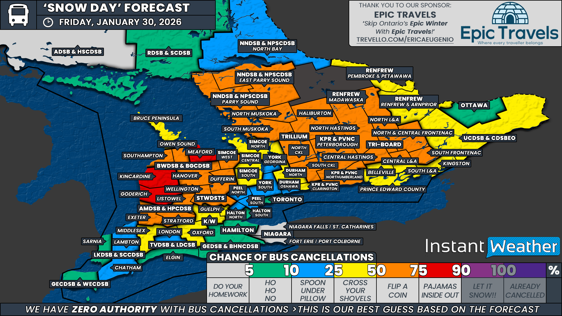
NOTE: YOU CAN CLICK ON THE MAP TO OPEN A ZOOMABLE IMAGE
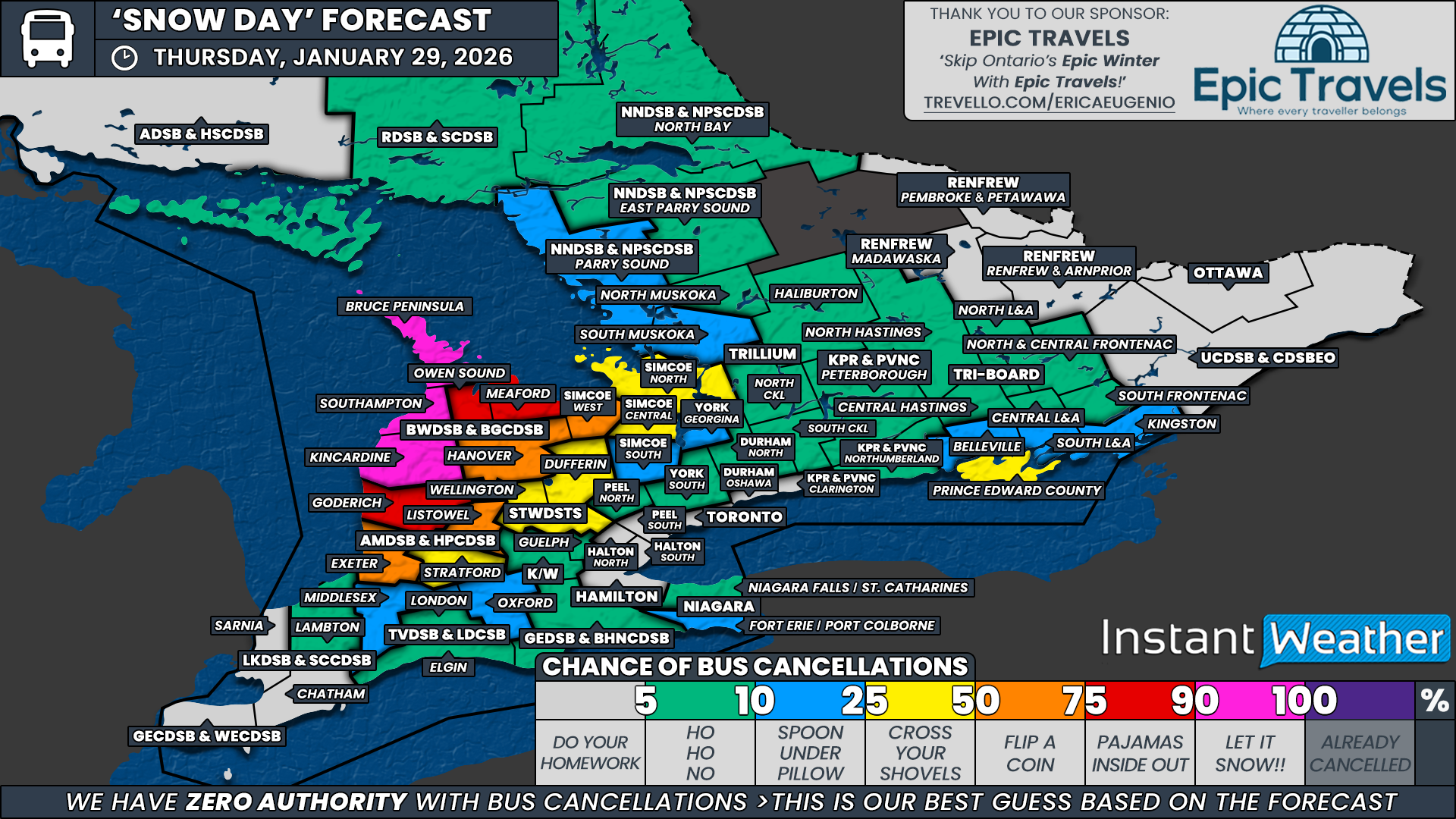
While snow squall activity around Lake Huron and Georgian Bay has underperformed so far on Thursday, allowing for fewer school bus cancellations than initially expected, the snow squall threat is not over just yet. Additional lake effect activity is expected to persist overnight and into Friday morning, keeping the door open for further disruptions.
On top of that, a surge of Arctic air will settle across Southern Ontario overnight. Temperatures in some areas are expected to fall toward -30°C, with wind chills making it feel closer to -40°C by Friday morning. That combination of lingering snow squalls and extreme cold could be enough to prompt at least some school boards to keep buses off the roads on Friday.
It’s also worth noting that many school boards have a PA Day scheduled for Friday. If that applies to your region, consider it a guaranteed cold day and enjoy sleeping through the worst of the wind chills. However, for the purpose of this forecast, we are treating Friday as a normal school day across all boards, as PA Day schedules vary and not every board follows the same calendar.
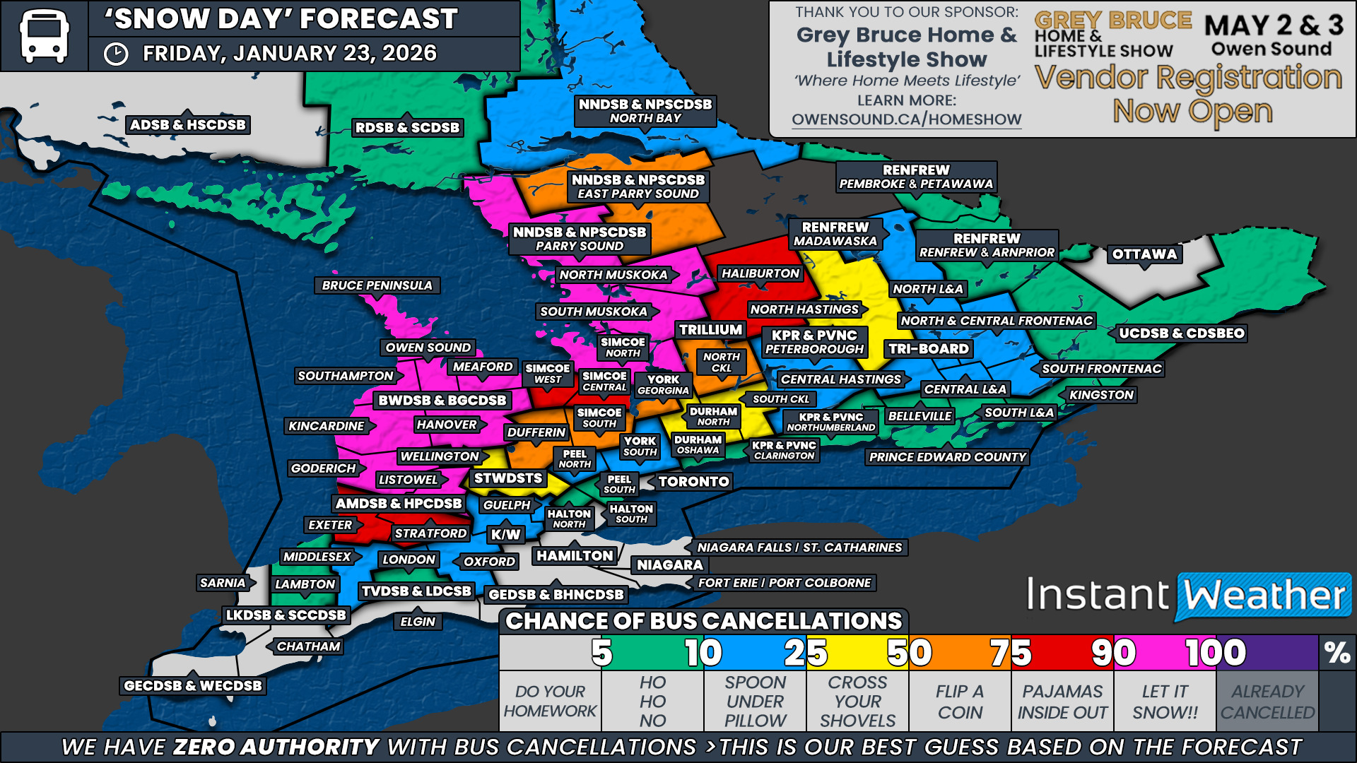
For school boards that are operating, our strongest confidence for bus cancellations is focused along the Lake Huron snowbelt. This includes Kincardine and Meaford within the Bluewater District School Board, along with northern Huron County under the Avon Maitland District School Board.
These areas are most likely to see renewed snow squall activity overnight if the bands are able to organize. However, given the inconsistent model performance with this lake effect setup, confidence is not high enough to place these regions in the highest category. As a result, we have kept them below the 90 percent threshold.
For the remainder of the Bluewater District School Board, excluding the Bruce Peninsula, as well as the rest of the Avon Maitland District School Board and the Simcoe West weather zone under the Simcoe County District School Board, we have assigned a 50 percent chance. In these areas, the risk comes from a combination of scattered snow squall impacts and the potential for extreme cold near cancellation thresholds.
A broad swath of Central and Eastern Ontario has also been placed in the 50 percent category due primarily to the cold. Typically, air temperatures near minus 30 degrees or wind chills approaching minus 40 are required before most school boards consider cancelling buses due to cold alone.
Current forecasts suggest many areas may come within just a few degrees of those thresholds, but could fall just short. Because of that uncertainty and the tendency for models to occasionally underestimate cold air outbreaks, we’ve gone with a 50 percent chance that could swing either way.
This 50 percent zone includes all regions covered by the Trillium Lakelands District School Board, Parry Sound and East Parry Sound under the Near North District School Board, Peterborough and Northumberland counties under the Kawartha Pine Ridge District School Board, the northern sections of Tri-Board Student Transportation Services, and the Madawaska region under the Renfrew County District School Board. This also extends into higher elevation areas of Southwestern Ontario, including Wellington and Dufferin counties within the Upper Grand District School Board.
For a slight chance of bus cancellations, we have included the remainder of the Renfrew County District School Board, the Upper Canada District School Board, the southern sections of Tri-Board Student Transportation Services, Clarington under the Kawartha Pine Ridge District School Board, northern Durham Region, the remaining Simcoe County District School Board weather zones, Guelph under the Upper Grand District School Board, the Waterloo Region District School Board, and Oxford and Middlesex counties under the Thames Valley District School Board.
These areas are either more urban in nature or are expected to see slightly warmer temperatures, which should keep them below cold day thresholds. However, if temperatures end up just a few degrees colder than forecast, a handful of surprise cancellations would not be out of the question.
For the rest of Southern Ontario, including the more urban school boards across the Golden Horseshoe and into Deep Southwestern Ontario, the chance of school bus cancellations remains low. While it will be cold, temperatures and wind chills are not expected to reach the levels typically required for widespread cold-related cancellations in these areas.
Disclaimer: Instant Weather has zero authority when it comes to bus and school closures.
It is completely up to the school boards, bus companies, local authorities, and parents to decide what is best for their children. This is our best guess based on our forecast.