Intense Snowstorm Could Bring Blizzard Conditions and Up to 30-60cm of Snow to Southern Ontario This Weekend

Published: January 23, 2025 - 4:50 PM

NOTE: YOU CAN CLICK ON THE MAP TO OPEN A ZOOMABLE IMAGE

The snowy weather isn’t letting up as yet another winter storm takes aim at Southern Ontario over the Family Day long weekend. This system will arrive in multiple waves, beginning Saturday and continuing through Sunday. By the time it moves out late Sunday, much of Southern Ontario could be buried under as much as 60 cm of snow.

Strong winds will develop throughout Sunday morning into the afternoon, with gusts reaching 50 to 80 km/h in some areas. These powerful winds, combined with heavy snowfall, will create dangerous whiteout conditions and may even reach blizzard criteria. Travel is expected to become difficult as early as Saturday morning, with conditions steadily worsening through the night and into Sunday.

The most hazardous conditions are expected Sunday morning and afternoon, as intense snowfall rates are combined with strong wind gusts, making all non-essential travel extremely dangerous. Highway closures are highly likely in the hardest-hit regions as plows struggle to keep up with rapid snowfall rates, while blowing and drifting snow significantly reduces visibility.

There is still some uncertainty regarding the storm's exact track, which will determine where the heaviest snowfall occurs. Areas along the Lake Erie shoreline and possibly parts of the Golden Horseshoe could see periods of freezing rain or ice pellets by late Sunday morning. While this would create its own hazards, any mixing would also lower overall snowfall totals.

As of now, Eastern and parts of Central Ontario appear to be in line for the highest snowfall amounts. Combined two-day snowfall totals could range from 30 to 60 cm by Sunday night, with 5-10 cm expected on Saturday and an additional 25-50 cm possible on Sunday.

HOURLY SNOWFALL RATE/intensity - MAP FROM WEATHERBELL

The storm will get underway Saturday morning as steady snow moves into Deep Southwestern Ontario from Michigan. It will spread into London and the Greater Toronto Area (GTA) by late morning. Some light flurries may reach Central and Eastern Ontario, but the more persistent snowfall will remain south of Lake Simcoe.

At this stage, conditions may not seem too severe, leading to the false impression that the storm has been overhyped. However, don’t be fooled—snowfall rates will gradually increase through the afternoon, reaching 1-2 cm per hour and steadily accumulating.

PRECIPITATION TYPE - MAP FROM WEATHERBELL

By mid-afternoon Saturday, light to moderate snowfall will have spread across most of Southern Ontario. The heaviest snowfall will be concentrated over Southwestern Ontario and the GTA, while Central and Eastern Ontario, including the Ottawa Valley, may only see scattered flurries.

There are indications that parts of Deep Southwestern Ontario—including Windsor, Chatham, and possibly London—may see a transition to ice pellets or freezing rain. Meanwhile, Kitchener, Hamilton, and the GTA should remain primarily snow.

HOURLY SNOWFALL RATE/intensity - MAP FROM WEATHERBELL

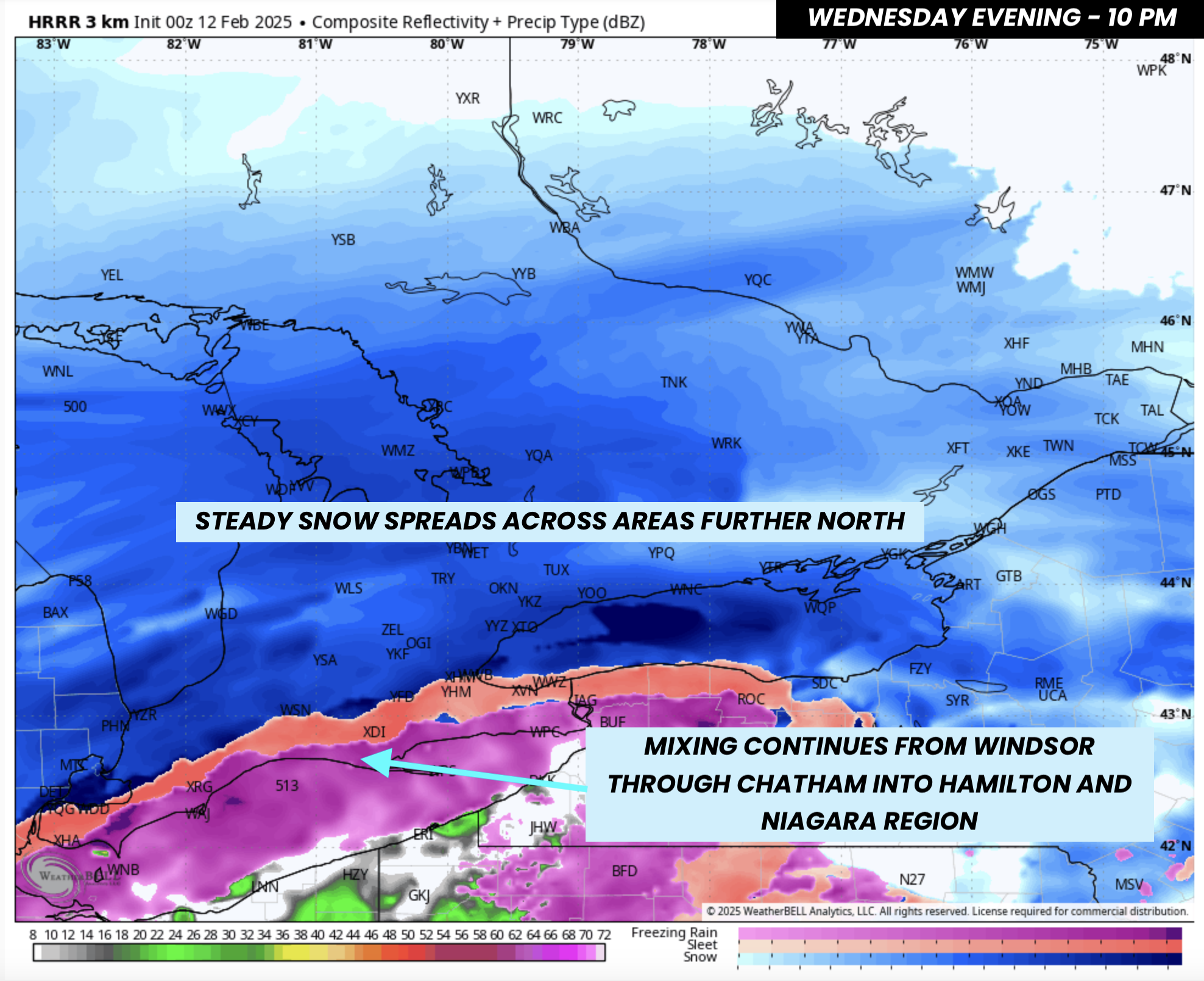
Heading into the evening, the storm’s moisture supply will intensify as it taps into the Gulf of Mexico, keeping snow steady across Southern Ontario. However, Central and Eastern Ontario may experience more scattered snowfall during this time. The most persistent snow bands are expected to set up along the Windsor-London-Hamilton corridor.

Some mixing could still occur near the Lake Erie shoreline, particularly in Leamington and the southern Niagara region, though it remains uncertain how far inland it may extend. If the mixing line pushes north, areas such as Windsor could also see freezing rain.

NOTE: YOU CAN CLICK ON THE MAP TO OPEN A ZOOMABLE IMAGE

By the end of Saturday, snowfall totals are expected to range from 5 to 10 cm across much of Southern Ontario, with locally higher amounts of up to 15 cm in areas benefiting from lake enhancement like Southwestern Ontario and the Golden Horseshoe.

Eastern Ontario and the Ottawa Valley will see lower totals, between 2 and 5 cm, as the first wave of snow stays focused farther south.

PRECIPITATION TYPE - MAP FROM WEATHERBELL

Conditions will deteriorate rapidly overnight Saturday as even more moisture-laden precipitation moves in from Michigan. Snowfall rates will increase during the pre-dawn hours, starting in the southwest around midnight before progressing east and north through the morning.

There remains some disagreement among forecast models regarding the extent of mixing along the Lake Erie shoreline, but there is a possibility of significant ice accretion in parts of Windsor and the Niagara region.

HOURLY SNOWFALL RATE/intensity - MAP FROM WEATHERBELL

By late Sunday morning, the system is expected to intensify rapidly as the low-pressure center tracks south of the Great Lakes. This intensification will result in significantly higher snowfall rates, especially in the GTA, Niagara region, and Central Ontario, including Barrie, Muskoka, and Peterborough.

Snowfall rates could reach 5-10 cm per hour, making it impossible for road crews to keep up. Eastern Ontario and the Ottawa Valley will see steady snow increase throughout Sunday afternoon and into the early evening.

ESTIMATED WIND GUSTS - MAP FROM WEATHERBELL

Adding to the severity of the storm, strong wind gusts of 50-80 km/h will develop through Sunday morning, with the highest gusts expected in Central and Eastern Ontario. These winds, combined with intense snowfall rates, will almost certainly lead to blizzard conditions in some areas.

Visibility will be near zero, with blowing and drifting snow making travel dangerous. All non-essential travel should be avoided on Sunday morning and afternoon, as highway closures are likely in the hardest-hit regions. With snow falling at rates of 5-10 cm per hour, it will be extremely easy to become stranded, as plows will struggle to keep roads passable.

PRECIPITATION TYPE - MAP FROM WEATHERBELL

Despite being less than 48 hours away, there is still some uncertainty in the storm's track and timing. Different forecast models continue to show varying scenarios, which could impact snowfall totals and the extent of mixing.

The short-range American model (HRRR), which provides detailed hourly forecasts, aligns closely with the Canadian and European models. These models suggest a more southern track, keeping the GTA and much of Southern Ontario primarily in the snow zone.

However, another American model (NAM) suggests a more northern track with a later arrival. If this scenario plays out, the mixing line would shift farther north, bringing ice pellets or freezing rain from London to Hamilton and into the GTA. This would reduce snowfall totals in these areas but create hazardous icy conditions.

This model also suggests the mixing could extend along the Lake Ontario shoreline into parts of Southeastern Ontario, including Belleville, Kingston, and Brockville. While this scenario is less likely, it’s still worth monitoring.

Additionally, the NAM model points to a significant icing event for Hamilton and the Niagara region, with potential ice accretion of 10-15 mm. If this happens, localized power outages and tree damage could occur.

The model also suggests that while some forecasts indicate the heaviest snow will arrive early Sunday, this scenario shifts the worst conditions to the afternoon in Southwestern Ontario and the GTA, extending into the evening for Eastern Ontario.

Regardless of the final track, conditions should improve as snow tapers off from west to east late Sunday evening, with lingering snow in Eastern Ontario into early Monday morning. However, lake-effect snow could quickly develop around Lake Huron and Georgian Bay as the system exits.

NOTE: YOU CAN CLICK ON THE MAP TO OPEN A ZOOMABLE IMAGE

By the time this storm is over, a wide swath of Eastern and Central Ontario could see 30-60 cm of fresh snow, including the accumulation from both Saturday and Sunday.

For Southwestern Ontario and the GTA—including Sarnia, London, Kitchener, Hamilton, and Toronto—snowfall totals will likely range from 20-40 cm. However, if mixing occurs on Sunday, snowfall amounts could drop to 15-30 cm or even lower, depending on how extensive the ice pellets or freezing rain become.

The lowest snowfall totals will likely be in Deep Southwestern Ontario and along the Lake Erie shoreline, where freezing rain and ice pellets will reduce overall accumulation. Areas such as Windsor, Leamington, Chatham, St. Thomas, and Niagara Falls could see between 15-30 cm of snow, depending on how much mixing occurs.

We are closely monitoring the latest forecast data and will provide a more detailed breakdown of Sunday’s snowfall totals in an updated forecast on Saturday. Stay tuned for further updates.

'Snow Day' Forecast: Bus Cancellations Possible on Friday in Southwestern & Central Ontario

For an updated list of school bus cancellations & school closures, please visit our live article: https://instantweatherinc.com/article/2025/2/14/bus-cancellations

NOTE: YOU CAN CLICK ON THE MAP TO OPEN A ZOOMABLE IMAGE

Snow squalls are expected to intensify late Thursday and continue into Friday, bringing hazardous winter conditions to areas near Georgian Bay and Lake Huron. These squalls will be capable of producing whiteout conditions with near-zero visibility, making travel extremely dangerous. In addition, snowfall accumulation could be rapid, leading to difficult and potentially impassable road conditions.

Environment Canada has issued snow squall warnings for several regions, highlighting the potential for snowfall totals between 20 and 40 cm by Friday afternoon. Given the expected intensity of these squalls, morning road conditions could be treacherous. As a result, school bus cancellations are highly likely in the hardest-hit areas.

The Bruce Peninsula and northern Simcoe County are at the highest risk for bus cancellations, as these areas are expected to experience the most persistent and intense snowfall overnight. Surrounding regions will also need to keep a close eye on conditions, as the likelihood of cancellations will depend on how strong the squalls become and whether significant snowfall accumulates before the morning commute.

Please note: We are aware that some school boards have a PA day on Friday. If your school board is affected, you can disregard this forecast. However, we continue to provide these updates regardless of PA days, as not all school boards follow the same schedule.

Here is a breakdown of the likelihood of school bus cancellations by region:

Almost Certain (90–99% Chance)

  • Bluewater District School Board (Bruce Peninsula)

  • Simcoe County District School Board (North Zone)

Likely (75–90% Chance)

  • Bluewater District School Board (Southampton, Owen Sound & Meaford)

  • Simcoe County District School Board (West Zone)

Possible (50–75% Chance)

  • Avon Maitland District School Board (Goderich)

  • Bluewater District School Board (Kincardine & Hanover)

  • Simcoe County District School Board (Central Zone)

  • Trillium Lakelands District School Board (North CKL)

Maybe (25–50% Chance)

  • Avon Maitland District School Board (Listowel)

  • STWDSTS (Dufferin)

  • Simcoe County District School Board (South Zone)

  • Trillium Lakelands District School Board (South Muskoka & South CKL)

Unlikely (10–25% Chance)

  • Avon Maitland District School Board (Exeter)

  • STWDSTS (Wellington)

  • Durham District School Board (North)

  • Kawartha Pine Ridge District School Board (Peterborough)

  • Trillium Lakelands District School Board (North Muskoka)

  • Near North District School Board (Town of Parry Sound)

For the rest of Southern Ontario, the chance of school bus cancellations is less than 10%.


Disclaimer: Instant Weather has zero authority when it comes to bus and school closures.

It is completely up to the school boards, bus companies, local authorities, and parents to decide what is best for their children. This is our best guess based on our forecast.

Will It Ever End? Squalls Could Bring Up to Another 40cm of Snow by the End of Friday to Parts of Southern Ontario

NOTE: YOU CAN CLICK ON THE MAP TO OPEN A ZOOMABLE IMAGE

Are you enjoying winter yet, Ontario? ❄️ It feels like we've been stuck in an endless cycle of snow, with relentless snow squalls hammering the snowbelt regions.

Even outside the snowbelts, much of Southern Ontario joined in this week as a major winter storm dumped over 20 cm of snow across the region overnight into Thursday morning.

And the snowy pattern isn’t letting up anytime soon. More lake effect snow is on the way to end the week, followed by a potentially significant snowstorm this weekend.

The lake effect machine is expected to fire back up Thursday evening, becoming more organized overnight into Friday morning. Current indications suggest a strong snow squall will develop, targeting the Bruce Peninsula and stretching into parts of Simcoe County.

While squall activity should begin to wind down by Friday afternoon, areas that have already been hit hard this season—such as Orillia, Midland, Wiarton, Lion’s Head, and Tobermory—could see another 15 to 25 cm of snow. If the squall locks into place for an extended period, localized totals of up to 40 cm are possible.

HOURLY SNOWFALL RATE/intensity - MAP FROM WEATHERBELL

As of early Thursday evening, bands of lake effect snow are already forming off Lake Huron and Georgian Bay. These will continue to shift around throughout the evening, delivering bursts of heavy snowfall to different areas.

Right now, it looks like the heaviest snowfall will be concentrated across the Bruce Peninsula and along the southeastern Georgian Bay shoreline, including Collingwood, Barrie, Angus, and Keswick. Additional, weaker bands may impact regions east of Lake Huron, from Owen Sound to Goderich.

By midnight, models suggest that a narrow but intense squall could set up, stretching from the Bruce Peninsula, over Georgian Bay, and into Barrie. However, there’s still uncertainty about its exact strength and how stationary it will be overnight. Some models show it drifting north toward Midland and Orillia, while others keep it in place longer.

If the squall aligns just right, it could connect with both Lake Huron and Georgian Bay, allowing it to tap into additional moisture. This could make it stronger than expected, potentially bringing more snow to Barrie than initially forecasted. Right now, Barrie sits right on the edge between significant snowfall and minimal accumulation.

HOURLY SNOWFALL RATE/intensity - MAP FROM WEATHERBELL

By Friday morning, the squall will likely continue hammering the Bruce Peninsula and Simcoe County but may have shifted slightly north, putting Tobermory, Midland, and Orillia in the bullseye for heavy snow during the late morning.

Depending on its strength, the squall could even extend into portions of Durham and the Kawartha Lakes at times. This squall may remain stationary for several hours, with snowfall rates reaching 5-10 cm per hour.

It won’t take long for roads to become impassable, especially along the Highway 400 and Highway 11 corridors. Plows will struggle to keep up with such intense snowfall rates, and whiteout conditions will make travel extremely dangerous. If you can, stay home—this is the kind of snow that can lead to major travel disruptions and accidents.

By early Friday afternoon, the squall should gradually weaken as winds shift and become less favourable for lake effect snow.

NOTE: YOU CAN CLICK ON THE MAP TO OPEN A ZOOMABLE IMAGE

As with any lake effect event, snowfall totals will be highly variable, depending on where these narrow snow bands set up.

The hardest-hit areas are expected to be across the Bruce Peninsula, including Tobermory, Lion’s Head, and Wiarton, extending into Simcoe County in areas like Midland, Washago, and Orillia. These regions could see 15 to 25 cm, with localized totals near 40 cm possible in central Simcoe County, closer to Georgian Bay.

Surrounding areas—including Grey-Bruce, Huron, and Perth counties east of Lake Huron—could see 5 to 15 cm, though some spots may see little to no snow due to how localized these bands are. Southern Muskoka, portions of Kawartha Lakes, and Durham Region may also receive up to 5 to 10 cm in some areas.

The rest of Southern Ontario should see less than 5 cm of snow over the next 24 hours, as the lake effect snow stays confined to the snowbelt regions.

While the lake effect snow wraps up Friday, a much bigger storm could be on the way this weekend. A potential multi-day snowfall event is on track to begin Saturday, and continue into Sunday.

Right now, there’s still uncertainty regarding snowfall totals and the exact timing of the worst conditions, but early indications suggest that much of Southern Ontario—particularly Eastern Ontario and the Golden Horseshoe—could see 20-30 cm or more by the end of the weekend.

We’re waiting on the latest model data this evening and will have a preliminary forecast on this potential snowstorm later today or early Friday. Stay tuned!

'Snow Day' Forecast: Widespread Bus Cancellations & School Closures Likely on Thursday as Winter Storm Bears Down on Southern Ontario

For an updated list of school bus cancellations & school closures, please visit our live article:


NOTE: YOU CAN CLICK ON THE MAP TO OPEN A ZOOMABLE IMAGE

A significant winter storm is set to impact Southern Ontario beginning Wednesday afternoon, lasting through the night, and continuing into Thursday morning.

Environment Canada has issued widespread winter storm warnings, snowfall warnings, and freezing rain warnings across the region, signalling the potential for hazardous conditions.

With snowfall totals expected to range between 20 and 40 cm by Thursday morning across Southwestern, Central, and Eastern Ontario, road conditions will likely be extremely treacherous.

Snowfall rates could exceed 5 cm per hour at times, making it difficult for snowplows to keep up. Even though the most intense conditions will occur Wednesday evening into the early overnight hours, the aftermath will still pose significant challenges for travel.

Given the severity of this storm, there is a very high likelihood that school buses will be cancelled across most of Southern Ontario. In fact, the probability of widespread bus cancellations across Southwestern, Central, and Eastern Ontario is over 90%.

School closures are also a strong possibility, particularly with Environment Canada's warnings emphasizing the dangers of travel on Thursday morning. Some school boards may even choose to announce cancellations proactively tonight. We will update this article if any school boards confirm closures in advance.

In the Golden Horseshoe and Niagara region, school boards tend to be more cautious when it comes to bus cancellations and school closures, as urban areas typically have better snow-clearing operations. However, there is also a chance of mixed precipitation in these regions, which could lower snowfall totals to around 10-20 cm.

This uncertainty makes cancellations less of a guarantee compared to other parts of the province. As a result, we’ve placed the likelihood of school bus cancellations at around 75% for Halton (South), Peel (South), York, Durham (South), and KPR (Clarington).

Meanwhile, for Toronto, Hamilton, and Niagara, it’s a 50/50 call and could go either way depending on how the storm unfolds overnight.

Deep Southwestern Ontario, including Windsor, Chatham, Sarnia, and London, also has a slightly lower probability of bus cancellations, sitting at around 75%. The system is expected to taper off earlier in these regions, and some areas could transition to rain by morning.

If that happens, conditions might improve enough for buses to operate. However, given the ongoing warnings from Environment Canada, school boards in these areas may still err on the side of caution and cancel transportation regardless.

Stay tuned for updates as the storm progresses, and check back for confirmation from school boards on closures and cancellations tonight and Thursday morning.


Disclaimer: Instant Weather has zero authority when it comes to bus and school closures.

It is completely up to the school boards, bus companies, local authorities, and parents to decide what is best for their children. This is our best guess based on our forecast.

High Impact Winter Storm on the Way for Southern Ontario Starting Wednesday With Up to 40cm of Snow & Freezing Rain

NOTE: YOU CAN CLICK ON THE MAP TO OPEN A ZOOMABLE IMAGE

Confidence is growing that Southern Ontario is on track for what could be the most widespread and significant winter storm of the season so far. That said, there hasn’t been much competition in that regard, as most of this winter’s snowfall has come from localized snow squalls. However, a shift in the weather pattern has placed the region in an active storm track, and Mother Nature isn’t wasting any time delivering a disruptive winter storm right in the middle of the week.

Earlier, there was some uncertainty regarding the exact track of the system, which would have influenced snowfall amounts in different areas. However, in the past 24 hours, forecast models have begun to align on a more consistent storm track. Interestingly, the latest data supports what we initially projected, meaning there hasn’t been a major shift in the forecast.

Widespread snowfall accumulations of 20 to 40 cm are expected from Southwestern Ontario through Central Ontario and into the Ottawa Valley between Wednesday and Thursday. In the Golden Horseshoe and Deep Southwestern Ontario, precipitation will likely begin as snow, but there is potential for ice pellets, freezing rain, or even regular rain to mix in. This could limit snowfall totals, especially along the shorelines of Lake Ontario and Lake Erie, where temperatures may hover near the freezing mark.

For the Greater Toronto Area (GTA), the extent of mixing remains a key uncertainty. It could go either way. Right now, we’re forecasting 10 to 20 cm of snow, but if the mixing line stays south, snowfall amounts could surpass expectations, reaching 25 to 30 cm.

In Deep Southwestern Ontario, including Windsor, Chatham, and extending into the Niagara region, models suggest several hours of freezing rain Wednesday evening and overnight. Some localized areas could see ice accretion of 2 to 5 mm, leading to slippery, untreated surfaces and hazardous road conditions.

PRECIPITATION TYPE - MAP FROM WEATHERBELL

The storm is expected to arrive Wednesday afternoon, with scattered precipitation moving into Southwestern Ontario between 2 and 4 PM. While most areas will initially see snow, some models are aggressive in bringing freezing rain into Windsor and Chatham by late afternoon.

Before the main storm arrives, lake-effect snow may develop off Lake Ontario, affecting the Burlington and Hamilton corridor Wednesday morning into early afternoon. System snow should reach the GTA just before the evening rush hour, making for a difficult commute.

The latest model data has also increased wind projections, with gusts of 40 to 60 km/h in some areas. Combined with heavy snowfall, this could lead to blowing snow and reduced visibility. Non-essential travel should be avoided starting in the late afternoon, with conditions deteriorating further into the evening.

PRECIPITATION TYPE - MAP FROM WEATHERBELL

By mid to late evening, snow will have spread across most of Southern Ontario, including Central and Eastern Ontario. A key feature to monitor will be the movement of the mixing line.

Current data shows a freezing rain corridor stretching from Leamington through Chatham and along the Lake Erie shoreline, with a narrow band of ice pellets from Windsor through just south of London and into Hamilton.

Meanwhile, heavy snow will persist across Sarnia, London, Kitchener, and the GTA. Snowfall rates will intensify after 9–10 PM, increasing from 1–2 cm per hour to 2–4 cm per hour. This will make it challenging for snowplows to keep up.

PRECIPITATION TYPE - MAP FROM WEATHERBELL

After midnight, the mixing line may push north into parts of the GTA, bringing ice pellets and freezing rain to locations such as London, Burlington, Mississauga, and Toronto for several hours. However, this transition looks to be confined near the Lake Ontario shoreline, meaning snowfall will likely dominate farther inland.

Freezing rain will continue across Windsor and along the Lake Erie shoreline into the Niagara region, while heavy snow steadily blankets Central and Eastern Ontario overnight.

PRECIPITATION TYPE - MAP FROM WEATHERBELL

The system will begin its exit Thursday morning, with snow tapering off in Southwestern Ontario first. However, snow will continue across Central and Eastern Ontario.

In the Niagara region and along the Lake Ontario shoreline, mixing will remain a concern into the early morning hours. However, by 4–6 AM, colder air will push in, flipping precipitation back to snow. Any previously fallen precipitation may refreeze as temperatures drop, creating hazardous road conditions.

Expect treacherous travel conditions on Thursday morning. Roads will be slushy and icy in areas that saw mixing, while heavy snow will make roads impassable further north. Widespread school bus cancellations and school closures are likely.

PRECIPITATION TYPE - MAP FROM WEATHERBELL

Eastern Ontario will hold onto light to moderate snow through the late morning. However, models indicate some potential for mixing in the Kingston, Brockville, and Cornwall areas. This could result in light icing from freezing rain before a final transition back to snow.

Most of Southern Ontario will finally see an end to precipitation Thursday, aside from some lingering lake-effect snow near Lake Huron.

NOTE: YOU CAN CLICK ON THE MAP TO OPEN A ZOOMABLE IMAGE

Based on the latest data, the highest snowfall totals will likely be in Central and Eastern Ontario. A widespread 20–40 cm is forecast across Southwestern, Central, and Eastern Ontario. However, totals closer to 40 cm are most probable in Eastern Ontario, including Ottawa, where there’s even a slight chance of locally exceeding 40–50 cm.

Central and Southwestern Ontario, including Grey-Bruce, Kitchener, York Region, Simcoe County, Muskoka, and Peterborough, will likely receive 20–30 cm, with some areas near Lake Simcoe potentially exceeding 30 cm.

The exception will be the Lake Ontario shoreline and the International border, including Kingston, Brockville, and Cornwall. Lower snowfall ratios and a higher risk of mixing could keep totals below 20 cm. However, if mixing remains minimal, this area could exceed forecasts.

NOTE: YOU CAN CLICK ON THE MAP TO OPEN A ZOOMABLE IMAGE

The snowfall forecast becomes more uncertain in Deep Southwestern Ontario and the Golden Horseshoe, where multiple factors create a ‘boom or bust’ scenario. The GTA will start with heavy snow, likely reaching 10 cm fairly easily unless there’s a drastic shift in the storm track. The big question is how much more accumulates beyond that.

Some models suggest that if mixing does not occur, parts of the GTA could see 20–30 cm by Thursday morning. However, given the likelihood of overnight mixing, we expect totals to stay below 20 cm, which is why our official forecast remains at 10–20 cm.

London and Sarnia sit on the boundary between significant snow and mixed precipitation. The most probable outcome is 15–20 cm, though an overperformance remains possible.

NOTE: YOU CAN CLICK ON THE MAP TO OPEN A ZOOMABLE IMAGE

In Deep Southwestern Ontario and the Niagara region, snowfall amounts will be lower, with less than 10 cm expected. However, these areas will likely see prolonged freezing rain, with the heaviest ice accretion along the Lake Erie shoreline.

Models vary on how intense the freezing rain will be. Some project as much as 10 mm of ice accretion, but this seems unlikely given the presence of mixed precipitation and the relatively short duration of freezing rain. Our official forecast calls for 2–5 mm of ice accretion, though isolated pockets could see 7–10 mm if freezing rain persists longer than expected.

Major Winter Storm on Track to Dump Up to 40cm of Snow Across Most of Southern Ontario Starting Wednesday

NOTE: YOU CAN CLICK ON THE MAP TO OPEN A ZOOMABLE IMAGE

Get your shovels ready, Southern Ontario! What many would consider our first true winter storm of the season is on the horizon. This moisture-laden system is set to arrive Wednesday afternoon, bringing heavy snowfall across a large portion of our region.

There’s still some uncertainty in the exact track, which will determine who sees the heaviest snow, but confidence is growing that much of Southern Ontario will experience significant impacts from this storm. Travel will likely become hazardous Wednesday evening into Thursday morning, and widespread school bus cancellations—and even full school closures—are almost certain on Thursday.

Based on the latest data, the heaviest snowfall is expected to stretch from Southwestern Ontario through Central Ontario and into the Ottawa Valley. Accumulations will likely range between 20 to 40 cm, with some localized pockets potentially exceeding 40 cm by the time the snow tapers off early Thursday afternoon.

The most challenging part of this forecast comes down to a narrow corridor from London through Hamilton, into the Greater Toronto Area (GTA), along the Lake Ontario shoreline, and into extreme Eastern Ontario along the international border. These areas are likely to start off with snow, but depending on the storm’s track, a transition to ice pellets, freezing rain, or even regular rain could occur during the evening and overnight.

The exact snowfall amounts in this corridor remain highly uncertain, as even a fraction of a degree difference in temperature could mean the difference between 5 cm and 30 cm of snow.

The risk of freezing rain also appears significant for areas in deep Southwestern Ontario, including Windsor, Chatham, and communities along the Lake Erie shoreline, where several hours of ice accretion could result in hazardous road conditions and localized power outages.

PRECIPITATION TYPE - MAP FROM WEATHERBELL

The storm will begin impacting Southern Ontario on Wednesday afternoon, with the initial bands of snow spreading into deep Southwestern Ontario, including Windsor, Sarnia, Chatham, and London. By the mid-to-late afternoon, snow will have moved into Hamilton, Niagara, and the Greater Toronto Area, just in time for the evening commute.

HOURLY SNOWFALL RATE/intensity - MAP FROM WEATHERBELL

Steady snowfall will continue through the dinner hour, with snowfall rates gradually increasing as the system spreads further across the region. Central and Eastern Ontario will see snow begin around the dinner hour into the early evening, while the Ottawa Valley may not see the first flakes until mid-to-late evening.

Snow will continue throughout the night across much of the region, with varying intensity. Unlike some past storms, this event isn’t expected to bring extreme snowfall rates, with accumulations of around 2 to 4 cm per hour at most. However, the prolonged nature of this storm, lasting 12 to 16 hours in many areas, will allow totals to build up significantly.

PRECIPITATION TYPE - MAP FROM WEATHERBELL

Another key factor in determining final snowfall amounts will be how far north the mixing line extends into Southern Ontario. Earlier model runs suggested a more northern track, which would allow warmer air to push into areas along the Lake Erie and Lake Ontario shorelines, leading to a transition from snow to ice pellets, freezing rain, or rain.

However, more recent model data from Monday evening has trended slightly further south, reducing the risk of mixing for some areas. That said, some models, including the American (NAM) and European models, still show a more northern mixing line, which could bring ice and rain into parts of deep Southwestern Ontario, London, and Hamilton.

If this occurs, Windsor and areas along the Lake Erie shoreline could see several hours of freezing rain, resulting in ice buildup on untreated surfaces, power lines, and roads.

PRECIPITATION TYPE - MAP FROM WEATHERBELL

On the other hand, the Canadian (RGEM) model, along with the higher-resolution American NAM 3km model, suggest a more southern storm track, which would keep most of Southern Ontario in the snow zone.

If this scenario plays out, snowfall accumulations could be much higher in places like London, Hamilton, and the Golden Horseshoe, with totals ranging from 20 to 30 cm and minimal mixing.

Some models also indicate the possibility of mixing slightly north of Lake Ontario and along the St. Lawrence River, including Kingston, Brockville, and Cornwall, which could lower snow totals in these areas. However, the latest data suggests this region may stay entirely on the snowy side of the system.

HOURLY SNOWFALL RATE/intensity - MAP FROM WEATHERBELL

As the storm progresses overnight, those areas that remain on the snow side will continue to see accumulation through early Thursday morning. Snowfall rates could briefly reach 2 to 4 cm per hour in heavier bands but will likely average closer to 1 to 2 cm per hour.

Fortunately, winds won’t be particularly strong, with gusts expected to range from 20 to 40 km/h at most. While some blowing snow is possible, full-blown blizzard conditions are not expected with this storm.

HOURLY SNOWFALL RATE/intensity - MAP FROM WEATHERBELL

By mid-morning Thursday, high-resolution models suggest a final burst of heavier snow around the Golden Horseshoe, Lake Simcoe, and Eastern Ontario. Snowfall rates could briefly spike to 4 to 6 cm per hour as the back end of the system moves through during the morning rush hour.

Travel conditions will likely be very poor on Thursday morning, and all non-essential travel should be avoided. Widespread school bus cancellations are almost a certainty given these conditions.

PRECIPITATION TYPE - MAP FROM WEATHERBELL

A rapid improvement is expected in Southwestern Ontario by late morning, with snowfall tapering off to light flurries. However, it will take time for road crews to clear the heavy snowfall, so road conditions may remain hazardous into the early afternoon.

For Central and Eastern Ontario, snow will linger into the early afternoon before finally winding down around midday for the GTA and Central Ontario and mid-afternoon for the Ottawa Valley.

NOTE: YOU CAN CLICK ON THE MAP TO OPEN A ZOOMABLE IMAGE

By the time the storm wraps up, a broad region across Southern Ontario, including the Lake Huron shoreline, Sarnia, Kitchener, Barrie, Muskoka, Peterborough, and the Ottawa Valley, will likely see between 20 and 40 cm of fresh snow. Mixing is unlikely to be a factor in these areas, though there’s always a slight chance of a last-minute shift in the storm track.

The biggest uncertainty lies within a narrow corridor that includes London, Woodstock, Hamilton, Mississauga, Toronto, Belleville, Kingston, Brockville, and Cornwall. This area will likely begin with snow on Wednesday but could see ice pellets, freezing rain, or rain mix in during the late evening and overnight hours, which would reduce total snowfall amounts.

A conservative estimate for this region is at least 10 cm of snow, though some areas, particularly along the northern edge of this zone, could see totals closer to 20 to 30 cm. The current model trends lean toward a slightly more southern storm track, but we are waiting to see if this pattern holds before making final adjustments to the snowfall forecast.

For Windsor, Chatham, and areas along the Lake Erie shoreline, including Niagara, a mix of snow and freezing rain is expected. Some locations could experience several hours of freezing rain, leading to ice accretion of 4 to 8 mm, which may cause localized power outages. However, if the mixing line remains further south, these areas could still end up seeing significant snowfall, possibly exceeding 20 cm.

The bottom line is that while we have high confidence in a significant winter storm, the local impacts will ultimately depend on the storm’s exact track, which may not become fully clear until just before the system moves in.

A more detailed forecast with refined snowfall and freezing rain estimates will be released late Tuesday as newer model data becomes available.

'Snow Day' Forecast: Extra Extra Long Weekend for Some Students in Southern Ontario With Bus Cancellations Possible on Monday

NOTE: YOU CAN CLICK ON THE MAP TO OPEN A ZOOMABLE IMAGE

The lake effect machine is set to roar back to life late Sunday into Monday, bringing another round of intense snow squalls to the snowbelt regions around Lake Huron and Georgian Bay.

While there is still some uncertainty regarding the strength and exact positioning of the heaviest squalls, conditions look severe enough to force school bus cancellations on Monday in the hardest-hit areas. After buses were already cancelled last Thursday and Friday, this could mark a third straight missed school day for some students.

Environment Canada has issued widespread snow squall watches and warnings stretching from Muskoka through Simcoe County and into Grey-Bruce. Some of these alerts warn of 20 to 50 cm of snowfall by the end of Monday, with blowing snow reducing visibility and making for treacherous driving conditions. With weather this severe, it’s hard to imagine school buses being able to safely operate in these regions.

The highest probability of school bus cancellations will be in the Bruce Peninsula, where heavy squalls are virtually guaranteed. In Simcoe County, the likelihood of cancellations remains high, but it all depends on exactly where the squalls develop. Some areas could get buried in snow, while others may see far less accumulation, leading to possible discrepancies in cancellations across different school zones.

For Muskoka and the Kawartha Lakes, snow squall watches are in effect, but the most intense snowfall is expected to stay south and west. While these areas won’t be the primary targets of this lake effect activity, there’s still a chance of bus cancellations depending on how conditions unfold overnight.

Outside of the snowbelt regions, the rest of Southern Ontario should remain unaffected by lake-effect snow on Monday. No school bus cancellations are expected in areas beyond the direct impact zone.

Here is a breakdown of the likelihood of school bus cancellations by region:

Almost Certain (90–99% Chance)

  • Bluewater District School Board (Bruce Peninsula)

Likely (75–90% Chance)

  • Bluewater District School Board (Owen Sound & Meaford)

  • Simcoe County District School Board (West & North Zone)

Possible (50–75% Chance)

  • Bluewater District School Board (Southampton, Kincardine & Hanover)

  • Simcoe County District School Board (Central Zone)

  • Trillium Lakelands District School Board (South Muskoka & North CKL)

Maybe (25–50% Chance)

  • Simcoe County District School Board (South Zone)

  • Trillium Lakelands District School Board (North Muskoka, South CKL & Haliburton)

  • Near North District School Board (Town of Parry Sound)

Unlikely (10–25% Chance)

  • Avon Maitland District School Board (Goderich)

  • STWDSTS (Dufferin)

  • Durham District School Board (North)

  • Near North District School Board (East Parry Sound)

For the rest of Southern Ontario, the chance of school bus cancellations is less than 10%.


Disclaimer: Instant Weather has zero authority when it comes to bus and school closures.

It is completely up to the school boards, bus companies, local authorities, and parents to decide what is best for their children. This is our best guess based on our forecast.

Snowy System Brings Double Digit Snowfall Accumulation to Greater Toronto Area & Southwestern Ontario This Weekend

NOTE: YOU CAN CLICK ON THE MAP TO OPEN A ZOOMABLE IMAGE

While many parts of Southern Ontario have been hit hard by snow squalls this winter, others have barely seen any accumulation.

The snowbelt regions east of Lake Huron and Georgian Bay have faced relentless lake-effect snow, while areas like Deep Southwestern Ontario, the Golden Horseshoe, and Southeastern Ontario have largely remained outside the squall zones.

The reason? This winter has been dominated by localized snow squalls rather than widespread storms. The extreme cold throughout January kept the storm track well south of the Great Lakes, shielding much of the region from major systems.

Aside from the occasional Alberta Clipper, it’s been relatively quiet. But that’s about to change as we shift into a more active storm track that places Southern Ontario directly in its path.

A moderately strong snowy system is on track to bring steady, accumulating snowfall across a wider area, including the GTA—one of the least snowy regions so far this season. Snow is expected to begin Saturday afternoon, with the heaviest accumulation occurring Saturday evening.

In fact, this system could bring Toronto its largest one-day snowfall of the season. The city’s current highest daily total sits at just 6.6 cm, recorded in early December. But with this storm, a widespread 10-15 cm of snow is looking increasingly likely, with some areas west of Lake Ontario possibly approaching 20 cm due to lake enhancement.

PRECIPITATION TYPE - MAP FROM WEATHERBELL

The first snow bands will push into Southern Ontario from the west by mid-afternoon Saturday, with flurries likely developing east of Lake Huron between 2-4 PM before spreading into the GTA around the dinner hour.

At first, the snowfall will be light, but intensity will gradually increase through the late afternoon and early evening as stronger snow bands move in. Windsor and Chatham could see some mixed precipitation, with a chance of freezing rain or drizzle before switching over to snow.

HOURLY SNOWFALL RATE/intensity - MAP FROM WEATHERBELL

By early evening, snowfall will expand across most of Southern Ontario, bringing steady accumulation.

The heaviest snow is expected west of Lake Ontario, stretching into Kitchener and Goderich, where snowfall rates could reach 1-2 cm per hour.

ESTIMATED WIND GUST - MAP FROM WEATHERBELL

Winds gusting 40-50 km/h along the Lake Erie shoreline Saturday evening may not be extreme, but they could still create minor blowing snow when combined with the steady snowfall, making travel conditions tricky.

HOURLY SNOWFALL RATE/intensity - MAP FROM WEATHERBELL

Snow will continue falling through the evening, gradually spreading toward Eastern Ontario. While Ottawa might see some light snow, accumulation should remain minimal.

The heaviest snow in Eastern Ontario will focus along the Lake Ontario shoreline, including Belleville and Kingston.

As we approach midnight, snow will begin tapering off from west to east, with Lake Huron regions clearing out first. For the GTA, heavier snow may persist a few hours past midnight before gradually weakening.

By early Sunday morning, the system will have moved out of most of Southern Ontario, with only lingering light snow possible in Eastern Ontario.

NOTE: YOU CAN CLICK ON THE MAP TO OPEN A ZOOMABLE IMAGE

Recent model trends suggest a stronger system than initially expected, though there remains some uncertainty. Forecasts have bounced between 5-10 cm and 15-25 cm in different model runs.

The current consensus suggests a general 10-15 cm corridor extending from Lake Huron through Kitchener, the Golden Horseshoe, and into the Kingston area, with localized pockets nearing 20 cm.

For areas further north, including Simcoe County, Kawartha Lakes, and Brockville, as well as Sarnia and London, 5-10 cm of snow is expected.

The least snowfall will be in the Ottawa Valley, where less than 5 cm is likely. Deep Southwestern Ontario, including Windsor and Chatham, will see the lowest totals, with 2-5 cm possible, along with the risk of freezing rain.

This will be one of the most widespread snowfalls of the season, especially for regions that have barely seen measurable snow this winter. Stay tuned for further updates as the system approaches.

'Snow Day' Forecast: Snow Squalls on Friday May Give a Long Weekend to Some Students in Southern Ontario

NOTE: YOU CAN CLICK ON THE MAP TO OPEN A ZOOMABLE IMAGE

Snow squalls are expected to develop off Lake Huron and Georgian Bay tonight and continue into Friday, bringing periods of heavy snowfall and reduced visibility. Some areas could see up to 25 cm of accumulation by the time the squalls wind down.

With widespread snow squall watches and warnings in effect for Grey-Bruce, Simcoe County, and Muskoka, there is a strong possibility that school boards in these regions will cancel buses on Friday morning. Hazardous road conditions, combined with a forecast that calls for ongoing snowfall throughout the day, will likely influence their decision.

The highest likelihood of school bus cancellations will be in the Bruce Peninsula and northern Simcoe County, where the worst conditions are expected right around the time when school boards must make their morning call. Roads in these areas may be heavily snow-covered, and blowing snow could further reduce visibility, making travel unsafe for school buses.

For surrounding areas, including Barrie, Owen Sound, and southern Muskoka, the chance of bus cancellations remains uncertain. While snow squalls may impact these regions, conditions may not be severe enough for widespread cancellations. However, with a snow squall watch or warning in place, some school boards may choose to err on the side of caution.

In Eastern Ontario, snowfall accumulations will be minor compared to the snowbelt, with up to 5 cm expected overnight. However, strong wind gusts could create localized blowing snow, reducing visibility in some areas. Rural school boards, particularly Tri-Board, which has a history of being overly cautious during winter weather events, could opt to cancel buses if road crews struggle to clear snow in time for the morning commute.

For the rest of Southern Ontario, school bus cancellations are unlikely. Snow squall activity will remain highly localized to the traditional snowbelt regions, leaving most other areas unaffected by significant snowfall or travel disruptions.

Here is a breakdown of the likelihood of school bus cancellations by region:

Almost Certain (90–99% Chance)

  • Bluewater District School Board (Bruce Peninsula)

  • Simcoe County District School Board (North Zone)

Likely (75–90% Chance)

  • Bluewater District School Board (Meaford)

  • Simcoe County District School Board (West Zone)

Possible (50–75% Chance)

  • Bluewater District School Board (Owen Sound & Southampton)

  • Simcoe County District School Board (Central Zone)

  • Trillium Lakelands District School Board (South Muskoka)

Maybe (25–50% Chance)

  • Avon Maitland District School Board (Goderich)

  • Bluewater District School Board (Kincardine & Hanover)

  • STWDSTS (Dufferin)

  • Simcoe County District School Board (South Zone)

  • Trillium Lakelands District School Board (North CKL)

  • Near North District School Board (Town of Parry Sound)

  • Tri-Board (North Hastings, North L&A & North Frontenac)

Unlikely (10–25% Chance)

  • Avon Maitland District School Board (Listowel)

  • STWDSTS (Wellington)

  • Durham District School Board (North)

  • Trillium Lakelands District School Board (North Muskoka, Haliburton & South CKL)

  • Near North District School Board (East Parry Sound)

  • Kawartha Pine Ridge District School Board (Peterborough)

  • Tri-Board (Central Hastings, Central L&A & South Frontenac)

  • Renfrew County District School Board (All Regions)

  • Upper Canada District School Board

For the rest of Southern Ontario, the chance of school bus cancellations is less than 10%.


Disclaimer: Instant Weather has zero authority when it comes to bus and school closures.

It is completely up to the school boards, bus companies, local authorities, and parents to decide what is best for their children. This is our best guess based on our forecast.

Snow Squalls to End Off the Week in Parts of Southern Ontario With Up to 25cm of Snow Possible by Friday

NOTE: YOU CAN CLICK ON THE MAP TO OPEN A ZOOMABLE IMAGE

While we’ve had a break from snow squall activity over the past week, they are expected to return as we close out the week, bringing another round of lake-effect snow to areas around Lake Huron and Georgian Bay.

As the system that brought a messy mix of wintry weather moves out, colder air will briefly settle into Southern Ontario. This drop in temperature, combined with strong westerly to northwesterly winds blowing over the still mostly ice-free lakes, will create the perfect conditions for snow squall development.

Overnight Thursday, shifting winds will likely trigger several narrow bands of heavy snow that will sweep across Southern Ontario before becoming more organized over Lake Huron and Georgian Bay.

While these bands won’t last long—most areas will only see snow for 15 to 30 minutes—they could still create hazardous driving conditions. Strong wind gusts of 70-80 km/h will cause blowing snow, significantly reducing visibility on the roads.

However, for regions within the snowbelt, which have already been hit hard by squalls in recent weeks, this could be another significant snowfall event. Parts of Grey-Bruce and Simcoe County may see totals reaching 15 to 25 cm in the hardest-hit communities by the end of Friday.

HOURLY SNOWFALL RATE/intensity - MAP FROM WEATHERBELL

More organized squalls are likely to develop early Friday morning, targeting the Bruce Peninsula and extending into Simcoe County. This narrow but intense band will likely persist throughout much of the day, though it may shift somewhat as winds fluctuate.

Current model data indicates that the heaviest snow will remain focused within the Wiarton-to-Owen Sound corridor in Grey-Bruce and between Orillia and Barrie in Simcoe County. At times, the squall could extend further inland, bringing periods of heavy snow to parts of Kawartha Lakes, Durham, and Peterborough during the morning and afternoon.

By Friday evening, a shift in wind direction will bring a few hours of intense snowfall to parts of Southern Muskoka, including MacTier, Port Carling, Bala, Gravenhurst, and Bracebridge. However, this squall is expected to weaken quickly after midnight as winds subside.

NOTE: YOU CAN CLICK ON THE MAP TO OPEN A ZOOMABLE IMAGE

With the snow band moving around throughout the day, widespread extreme accumulations are less likely, but it will allow more regions to see bursts of heavy snowfall at different times.

We’re expecting total snowfall accumulations of 15 to 25 cm across the central Bruce Peninsula, including Wiarton and Lion’s Head, extending into most of Simcoe County.

The City of Barrie is expected to avoid the worst of the snowfall, but if the squall sinks slightly farther south for a few hours, the city could still see around 10-15 cm of accumulation.

For the rest of Grey-Bruce, including Owen Sound, Hanover, and Collingwood, as well as Muskoka, Kawartha Lakes, and Peterborough, snowfall totals will generally range between 5 to 10 cm, though some localized pockets may receive up to 15 cm.

Outside of the snowbelt, snowfall will be minimal, with 2-5 cm expected across the rest of Central Ontario and less than 2 cm for Eastern Ontario and the Golden Horseshoe.

Deep Southwestern Ontario will likely remain snow-free from this round of lake-effect snow.

PRECIPITATION TYPE - MAP FROM WEATHERBELL

After the snow squalls, attention will turn to Saturday night, which, at one point, looked like it could bring Southern Ontario its strongest winter storm of the season. However, recent model data now suggests that much of the system’s moisture may stay south of the border, shifting into the U.S. Northeast instead.

If this trend continues, instead of widespread snowfall totals of 10-20 cm, most of Southern Ontario could see just 5 to 10 cm—and even that might be on the high end.

For those hoping for a big winter storm, it looks like luck isn’t on your side this time. That said, we’re still in an active storm track, and the next few weeks will bring more chances for Southern Ontario to get hit with a classic winter storm.

'Ice Day' Forecast: Freezing Rain Likely to Cancel School Buses in Parts of Southwestern Ontario on Thursday

NOTE: YOU CAN CLICK ON THE MAP TO OPEN A ZOOMABLE IMAGE

A messy mix of wintry weather is set to move into Southern Ontario early Thursday morning, bringing a mix of snow and freezing rain depending on location. The exact impacts will vary widely across the region, with mainly light snow expected in Central and Eastern Ontario, while areas further south, particularly in Southwestern Ontario, face a higher risk of prolonged freezing rain.

Environment Canada has issued a Freezing Rain Warning for Windsor and Chatham, indicating hazardous travel conditions in these areas. With freezing rain expected to be falling right during the morning bus run, there is a strong likelihood of school bus cancellations in these regions.

The probability of cancellations decreases significantly as you move further north, where freezing rain is less of a concern. Instead, a mix of snow and ice pellets is expected, but accumulation may not be enough to meet the threshold for widespread bus cancellations.

That said, the possibility cannot be completely ruled out. As a result, we’ve assigned a very low chance of school bus cancellations across Central and Eastern Ontario. There remains a small possibility that a few isolated school boards may decide to cancel buses, particularly if Environment Canada issues a Winter Weather Travel Advisory or other alert overnight.

One key factor is that most of the snowfall accumulation will occur after school bus decisions are made early in the morning. This makes proactive cancellations less likely, especially since projected snowfall totals are expected to remain in the 5 to 10 cm range. Unless conditions deteriorate more than currently forecast, school boards will likely proceed as usual.

Here is a breakdown of the likelihood of school bus cancellations by region:

Likely (75–90% Chance)

  • Greater Essex County District School Board

  • Lambton Kent District School Board (Chatham)

Possible (50–75% Chance)

  • Lambton Kent District School Board (Sarnia & Lambton)

  • Thames Valley District School Board (Middlesex & Elgin)

Maybe (25–50% Chance)

  • Thames Valley District School Board (City of London & Oxford)

  • Avon Maitland District School Board (Exeter & Stratford)

  • Grand Erie District School Board

  • District School Board of Niagara (South)

Unlikely (10–25% Chance)

  • Avon Maitland District School Board (Goderich & Listowel)

  • STWDSTS (Wellington & Dufferin)

  • Waterloo Region District School Board

  • Peel District School Board (North)

  • Halton District School Board (North)

  • District School Board of Niagara (North)

For the rest of Southern Ontario, the chance of school bus cancellations is less than 10%.


Disclaimer: Instant Weather has zero authority when it comes to bus and school closures.

It is completely up to the school boards, bus companies, local authorities, and parents to decide what is best for their children. This is our best guess based on our forecast.

Wintry Mix of Snow, Sleet and Freezing Rain Threatens Thursday Morning Commute Across Southern Ontario

NOTE: YOU CAN CLICK ON THE MAP TO OPEN A ZOOMABLE IMAGE

A shift in the weather pattern across Southern Ontario over the past few days has brought a noticeable retreat from the extreme cold, with temperatures returning to near-seasonal values. However, this shift has also placed the region on a more active storm track, a pattern we first experienced with Monday’s messy system.

The next round of unsettled weather was initially showing signs of a prolonged freezing rain event on Thursday. However, recent model trends indicate a significantly weaker system than previously expected. While this storm will still impact Southern Ontario, the main threat now appears to be light freezing rain and snow, particularly during the Thursday morning commute.

Although snowfall totals won’t be overly impressive, Central and Eastern Ontario could see an average accumulation of 4 to 8 cm by the end of the day. The primary concern will be the mix of precipitation types, which could create slushy and icy road conditions, making for a slick and potentially hazardous commute.

Looking ahead to the weekend, we are closely watching a moisture-laden system that could bring Southern Ontario its first true widespread snowstorm of the season. This storm has the potential to impact even those regions that have largely avoided significant snowfall so far, including Deep Southwestern Ontario and the Golden Horseshoe.

Current projections suggest snowfall totals could range from 10 to 25 cm, though these estimates will likely be refined as we get closer to the event.

PRECIPITATION TYPE OVER LAST 6 HOURS - MAP FROM WEATHERBELL

Thursday’s system is expected to begin during the morning hours as light precipitation moves in from the southwest. High-resolution models, such as the American model shown above, suggest that the precipitation will be quite scattered with dry pockets throughout. However, if the precipitation takes the form of light flurries or drizzle, some models may be underestimating its extent.

For Central and Eastern Ontario, precipitation will likely fall as snow. Across the Golden Horseshoe, it may also start as snow during the mid-morning hours before transitioning. Meanwhile, areas along the Lake Erie shoreline and Deep Southwestern Ontario will be more prone to freezing rain and ice pellets from the onset.

Travel conditions could become challenging, particularly in the morning as freezing rain coincides with rush hour across Southwestern Ontario and into the Golden Horseshoe.

At this point, it’s uncertain whether this system will be strong enough to prompt widespread school bus cancellations. However, the highest risk for disruptions will be in Windsor, Chatham, and London, where precipitation is expected to begin earlier in the morning with a higher likelihood of freezing rain.

PRECIPITATION TYPE OVER LAST 6 HOURS - MAP FROM WEATHERBELL

By early afternoon, precipitation should become more widespread, particularly in Central and Eastern Ontario, as drier areas fill in with moisture. Despite this, snowfall rates are expected to remain manageable, likely staying under 1 cm per hour. However, snow could persist for a solid 6 to 8 hours through the late morning and afternoon, leading to gradual accumulation.

Meanwhile, the freezing rain threat will begin expanding toward Hamilton and the western GTA, with ice pellets potentially mixing in as the transition from snow to freezing rain occurs.

Gradually, precipitation will taper off in Deep Southwestern Ontario, with lingering drizzle as temperatures slowly rise above freezing. This slight warm-up will help melt any ice accretion from earlier in the day.

Across the rest of Southern Ontario, precipitation should wind down by late afternoon or early evening. In the wake of the system, some minor lake-effect snow may develop around Georgian Bay and Lake Huron, but we are not expecting any organized lake-effect activity at this time.

PRECIPITATION TYPE OVER LAST 6 HOURS - MAP FROM WEATHERBELL

While Thursday’s system may be relatively minor, it could serve as a precursor to a much more impactful storm set to arrive this weekend.

Uncertainties remain, and details could shift as we get closer to Saturday. However, all major weather models continue to signal a strong system targeting Southern Ontario late Saturday into Sunday.

The exact track and intensity will determine which areas see the most significant impacts. At this point, current projections suggest a prolonged freezing rain threat for Deep Southwestern Ontario and areas along the Lake Erie shoreline. Meanwhile, heavy snow, with potential accumulations between 10 and 25 cm, could affect parts of the Golden Horseshoe, Central Ontario, and Eastern Ontario.

Again, this forecast is subject to change, but this storm has the potential to be a high-impact event for much of Southern Ontario. Stay tuned, as we’ll be providing more detailed updates in the coming days!

Willie Is Wrong! February Roars Into Southern Ontario With Up to 10cm of Snow for Central & Eastern Ontario on Monday

NOTE: YOU CAN CLICK ON THE MAP TO OPEN A ZOOMABLE IMAGE

Wiarton Willie emerged from his burrow on Sunday morning and didn’t see his shadow, predicting an early spring. But as Southern Ontario residents wake up to an active weather pattern, it looks like Mother Nature may have other plans.

A stormy week is ahead, with multiple systems taking aim at the region. The first arrives Monday, bringing a messy mix of heavy snow, freezing rain, and rain. Central and Eastern Ontario will bear the brunt of the snowfall, while areas northwest of the GTA could see prolonged freezing rain.

The most significant concern, however, is a potentially high-impact storm on Thursday. Current model data points to a prolonged freezing rain event for Southwestern Ontario and the Golden Horseshoe, though the exact track remains uncertain. A slight shift north or south could change precipitation types and affected areas.

PRECIPITATION TYPE - MAP FROM WEATHERBELL

The first storm system of the week will begin affecting Southern Ontario late Monday morning. Light to moderate snow will spread into Grey-Bruce, Muskoka, Parry Sound, and areas east of Georgian Bay.

At the same time, a light freezing drizzle could develop across parts of the GTA, Kitchener, and London, though it should remain fairly light and not overly impactful. Still, untreated roads and sidewalks could become slick.

PRECIPITATION TYPE - MAP FROM WEATHERBELL

By early to mid-afternoon, the storm will intensify, with moderate to heavy snow spreading into Central and Eastern Ontario, including Ottawa, Peterborough, and Barrie.

At the same time, freezing rain may become prolonged in a narrow corridor northwest of the GTA, affecting Shelburne, Orangeville, and northern York Region.

Further south, rain will dominate along the Lake Ontario shoreline and into Southwestern Ontario.

PRECIPITATION TYPE - MAP FROM WEATHERBELL

As Monday evening approaches, the storm will begin to taper off from west to east. Snow will transition to flurries in Southwestern Ontario around dinnertime, while Central and Eastern Ontario will see precipitation continue into the evening before ending around midnight.

However, freezing rain may linger longer in higher elevations northwest of the GTA, potentially impacting Guelph and Kitchener.

NOTE: YOU CAN CLICK ON THE MAP TO OPEN A ZOOMABLE IMAGE

While this storm won’t produce extreme snowfall rates, widespread accumulation is expected across Central and Eastern Ontario. Most areas from Grey-Bruce through Muskoka, Simcoe County, Peterborough, Kingston, Ottawa, and Cornwall will see 5 to 10 cm of snow.

Localized areas near Georgian Bay could exceed expectations, as lake enhancement may fuel pockets of heavier snow, pushing some totals closer to 15 cm. However, confidence remains low in this scenario, so no forecast upgrades have been made to the 10-20 cm range.

South of these regions, snowfall amounts will drop quickly as precipitation transitions to freezing rain and rain. The northern GTA and Durham Region could see 2-5 cm of accumulation, with icing concerns in a narrow corridor stretching from Kincardine through Orangeville, Newmarket, Oshawa, Belleville, and Kingston.

NOTE: YOU CAN CLICK ON THE MAP TO OPEN A ZOOMABLE IMAGE

Freezing rain could be persistent, with most areas seeing around 2 mm of ice accretion.

However, in higher elevations like the Dundalk Highlands, up to 4 mm of ice could accumulate, increasing the risk of localized slick conditions.

PRECIPITATION TYPE - MAP FROM WEATHERBELL

As Monday’s system moves out, attention turns to a more significant storm later in the week.

A major winter storm is possible on Thursday, with global weather models consistently highlighting the risk of prolonged freezing rain. Right now, Southwestern Ontario and the Golden Horseshoe appear to be in the bullseye. However, the storm’s track remains uncertain, and even a small shift north or south could drastically alter the precipitation types and affected areas.

  • A more southerly track would favour a snowstorm for Southern Ontario.

  • A more northerly track would put Central and Eastern Ontario at risk for significant icing.

Regardless of the final path, Thursday’s storm could bring major disruptions, particularly to the morning commute. Widespread school bus cancellations appear likely based on current data, though details may change as the system evolves.

Stay tuned for updates as we track these storms!

'Snow Day' Forecast: Alberta Clipper Likely to Cause Widespread School Bus Cancellations Across Southern Ontario on Wednesday

NOTE: YOU CAN CLICK ON THE MAP TO OPEN A ZOOMABLE IMAGE

Heavy snow is currently sweeping across Southern Ontario as an Alberta Clipper makes its way through the region. By Wednesday morning, this system is expected to deliver widespread snowfall totals of up to 15 cm across Eastern, Central, and Southwestern Ontario.

In addition to the snowfall from the system itself, lake effect snow will develop in the wake of the clipper, primarily around Lake Huron and Georgian Bay.

These squalls are expected to begin during the late morning and continue into Wednesday afternoon. Environment Canada has issued snow squall watches for these regions, which are likely to be upgraded to warnings by early Wednesday.

With heavy snow persisting overnight and the added impact of lake effect snow during the day, it is highly likely that school boards in affected areas will cancel school buses on Wednesday.

Most of the snow from the Alberta Clipper will fall Tuesday evening and taper off overnight for areas outside the snowbelt. However, rural regions may still struggle to clear backroads in time for the morning commute. This was evident on Tuesday when widespread cancellations occurred despite the snow ending hours before the morning bus runs.

Conditions on Wednesday are expected to be similar or even worse in some areas, particularly in Eastern Ontario, where snow will still be falling during the early morning hours.

The greatest likelihood of a "snow day" will be in rural school boards in Eastern Ontario, which are typically more cautious when it comes to heavy snow. Grey, Bruce, and Huron counties are also strong candidates for cancellations, as these areas are still digging out from previous snowfalls and are expected to see additional squalls on Wednesday.

For the rest of Central and Eastern Ontario, school bus cancellations remain uncertain. Decisions will largely depend on local road conditions and how efficiently crews can clear roads, especially critical backroads.

Urban areas like Ottawa and the Greater Toronto Area are not expected to experience enough snow to trigger bus cancellations. However, Ottawa has a slightly higher chance than Toronto due to ongoing snowfall during the early morning hours, which may make the roads more difficult to clear.

Here is a breakdown of the likelihood of school bus cancellations by region:

Almost Certain (90–99% Chance)

  • Avon Maitland District School Board (Goderich)

  • Bluewater District School Board (Kincardine & Southampton)

  • Tri-Board (North Hastings, North L&A & North Frontenac)

Likely (75–90% Chance)

  • Avon Maitland District School Board (Exeter, Stratford & Listowel)

  • Bluewater District School Board (Bruce Peninsula, Owen Sound, Meaford & Hanover)

  • Simcoe County District School Board (West Zone)

  • Kawartha Pine Ridge District School Board (Peterborough)

  • Trillium Lakelands District School Board (Haliburton)

  • Tri-Board (Centre Hastings, Central L&A & South Frontenac)

  • Renfrew County District School Board (Madawaska)

  • Upper Canada District School Board

Possible (50–75% Chance)

  • STWDSTS (Wellington & Dufferin)

  • Simcoe County District School Board (Central & North Zone)

  • Trillium Lakelands District School Board (Muskoka & CKL)

  • Near North District School Board (Town of Parry Sound)

  • Kawartha Pine Ridge District School Board (Northumberland)

  • Tri-Board (Belleville, Prince Edward County, South L&A & Kingston)

  • Renfrew County District School Board (Renfrew & Pembroke)

Maybe (25–50% Chance)

  • Thames Valley District School Board (Middlesex & Oxford)

  • Waterloo Region District School Board

  • Simcoe County District School Board (South Zone)

  • Near North District School Board (East Parry Sound)

  • Kawartha Pine Ridge District School Board (Clarington)

  • Ottawa-Carleton District School Board

Unlikely (10–25% Chance)

  • Thames Valley District School Board (London & Elgin)

  • Halton District School Board (North)

  • Peel District School Board (North)

  • York Region District School Board

  • Durham District School Board (North)

  • Near North District School Board (North Bay)

  • Rainbow District School Board

  • Algoma District School Board

For the rest of Southern Ontario, the chance of school bus cancellations is less than 10%.


Disclaimer: Instant Weather has zero authority when it comes to bus and school closures.

It is completely up to the school boards, bus companies, local authorities, and parents to decide what is best for their children. This is our best guess based on our forecast.

Another Dumping of Snow as an Alberta Clipper Targets Southern Ontario With Up to 20cm of Snow by Wednesday

NOTE: YOU CAN CLICK ON THE MAP TO OPEN A ZOOMABLE IMAGE

As January 2025 draws to a close, Southern Ontario’s weather has varied greatly depending on the region.

Snowbelt areas near Lake Huron and Georgian Bay have been bombarded by persistent lake-effect snow over the past couple of weeks. Meanwhile, Eastern and Deep Southwestern Ontario have seen little snow this month, as no significant systems have impacted those areas.

That pattern is about to shift, with an Alberta Clipper poised to bring a widespread snowfall event across Southern Ontario. This system is expected to deliver 10 to 20 cm of snow to Eastern, Central, and Southwestern Ontario over the next 24 hours, including the snowbelt regions.

In addition to the clipper, snow squalls are forecast to develop Wednesday afternoon and continue into the evening. Combined system snow and lake effect snow could bring an additional 20 to 30 cm to areas east of Lake Huron between Tuesday and Wednesday.

PRECIPITATION TYPE - MAP FROM WEATHERBELL

Snowfall from the clipper has already begun moving into Southwestern Ontario near Lake Huron as of late Tuesday afternoon.

Moderate to heavy snow will spread eastward through the evening, with the heaviest snow expected in the Greater Toronto Area (GTA) and Central Ontario during the late afternoon and early evening.

Localized heavier snow is likely along the Lake Huron and Georgian Bay shorelines, particularly over the Bruce Peninsula, where lake enhancement will add extra moisture to the system.

PRECIPITATION TYPE - MAP FROM WEATHERBELL

For Southwestern Ontario, snowfall will begin to taper off by the evening and should exit areas southwest of Lake Simcoe by midnight.

Central and Eastern Ontario will continue to see snow through the early overnight hours, with the Ottawa Valley potentially experiencing snowfall until Wednesday morning, tapering off around sunrise.

HOURLY SNOWFALL RATE/intensity - MAP FROM WEATHERBELL

Following the system’s departure, lake effect snow is expected to ramp up over Lake Huron and Georgian Bay.

Models indicate disorganized snow bands developing off Lake Huron on Wednesday afternoon, impacting areas like Grey, Bruce, Huron, and Perth counties. These bands may occasionally extend as far as Kitchener and Hamilton.

Additionally, a snow squall may form southeast of Georgian Bay, bringing heavy snow to the Barrie and Innisfil areas Wednesday afternoon. The intensity and duration of this squall remain uncertain.

By Wednesday evening, activity over Lake Huron may consolidate into a stronger squall targeting the corridor between Southampton and Kincardine, potentially extending to the Hanover area. This squall could lead to rapid snowfall accumulation before gradually weakening after midnight.

NOTE: YOU CAN CLICK ON THE MAP TO OPEN A ZOOMABLE IMAGE

The highest snowfall totals over the next 24 hours are expected in the Grey-Bruce region.

Communities such as Port Elgin, Kincardine, Owen Sound, Chatsworth, Mildmay, and Hanover are forecast to receive 10 to 15 cm of snow from the clipper and an additional 10 to 20 cm from lake effect snow on Wednesday.

This could bring total accumulations to 20 to 30 cm, with isolated pockets potentially exceeding 30 cm.

Across Central and Eastern Ontario, Alberta Clipper snowfall is generally expected to range from 10 to 15 cm. Areas southeast of Georgian Bay, including Barrie, may see near 20 cm due to the added snow from Wednesday afternoon’s localized squalls.

Lower totals are expected in the GTA and Niagara regions, as the system’s moisture will primarily focus further north, and lake enhancement will not play a role.

Snowfall amounts in the GTA are expected to range from 4 to 8 cm, with Hamilton and the Niagara corridor seeing even less at 2 to 4 cm.

Deep Southwestern Ontario, including Windsor, Chatham, Sarnia, and London, will see little to no snow from this system. London could receive a few centimetres, while Windsor may only see a trace.

Looking ahead, we are monitoring a potential system moving in on Friday, which could bring snow and freezing rain to parts of Southern Ontario. Stay tuned for updates.

'Snow Day' Forecast: Will Grey-Bruce Ever Go Back to School? Another Day of Bus Cancellations Possible on Tuesday

NOTE: YOU CAN CLICK ON THE MAP TO OPEN A ZOOMABLE IMAGE

Heavy snow is set to sweep across Southern Ontario on Monday evening, bringing blizzard conditions and widespread blowing snow. The combination of reduced visibility and drifting snow will make travel hazardous in many areas.

Fortunately, in most regions, the snowfall is expected to taper off well before Tuesday morning. Winds will also weaken significantly overnight, leading to improved conditions by the time the morning bus run begins. Because of this, we do not anticipate widespread school bus cancellations across Southern Ontario on Tuesday.

However, the arrival of much colder air overnight will trigger lake-effect snow bands east of Lake Huron and south of Georgian Bay. Environment Canada has issued snow squall warnings and watches for these areas, warning of poor travel conditions that could persist into Tuesday morning.

As a result, school bus cancellations are likely in regions such as Grey, Bruce, Huron, and Perth counties, where snowfall and blowing snow could create treacherous driving conditions. For students in Grey-Bruce, this could mark their seventh consecutive snow day, following cancellations last week and on Monday.

The heaviest snowfall from this system is expected in the Parry Sound and North Bay regions, where totals of up to 20 cm are possible. Given the school board's cautious approach to winter weather, there is a slight chance of cancellations in these areas, even if conditions improve significantly by the morning.

Here is a breakdown of the likelihood of school bus cancellations by region:

Likely (75–90% Chance)

  • Avon Maitland District School Board (Goderich & Exeter)

  • Bluewater District School Board (Kincardine and Meaford)

Possible (50–75% Chance)

  • Avon Maitland District School Board (Listowel & Stratford)

  • Bluewater District School Board (Southampton, Hanover, Owen Sound & Bruce Peninsula)

  • Simcoe County District School Board (West Zone)

Maybe (25–50% Chance)

  • Near North District School Board (All Zones)

Unlikely (10–25% Chance)

  • Thames Valley District School Board (Middlesex)

  • STWDSTS (Wellington & Dufferin)

  • Simcoe County District School Board (Central & North Zone)

  • Trillium Lakelands District School Board (Muskoka, Haliburton & North CKL)

  • Rainbow District School Board

For the rest of Southern Ontario, the chance of school bus cancellations on Monday is less than 10%.


Disclaimer: Instant Weather has zero authority when it comes to bus and school closures.

It is completely up to the school boards, bus companies, local authorities, and parents to decide what is best for their children. This is our best guess based on our forecast.

'Snow Day' Forecast: Looming Blizzard Risk Could Cancel School Buses in Parts of Southern Ontario on Monday

NOTE: YOU CAN CLICK ON THE MAP TO OPEN A ZOOMABLE IMAGE

A mix of strong wind gusts and heavy snowfall is expected to create blizzard conditions starting Monday afternoon across parts of Southern Ontario.

Environment Canada has issued a blizzard warning for areas along the Eastern Georgian Bay shoreline, with a weather advisory extending through Muskoka and into Northern Ontario. These alerts signal the potential for hazardous weather, with significant impacts on visibility and travel conditions.

Given the seriousness of the situation, it is likely that school boards in the most affected regions will cancel school buses on Monday. However, for much of Southwestern and Eastern Ontario, widespread bus cancellations appear less likely. This is because the worst of the weather is expected to develop after the afternoon bus run, reducing the chances of a "snow day" for most students in these areas.

In regions where Environment Canada has issued blizzard warnings or advisories, conditions could deteriorate quickly during the afternoon hours. Central Ontario, including Muskoka, is expected to experience snow starting as early as 2 PM. In these areas, proactive decisions by school boards will be crucial to ensure safety, especially for students returning home in worsening weather.

For other parts of Southern Ontario, where the snow and strong winds are not expected to intensify until later in the day, the afternoon bus run should proceed without issue.

Ultimately, whether buses are cancelled will depend on how each school board interprets the forecast and balances the safety of students with the logistical realities of the storm’s timing. The further southeast you are located, the lower the chance of bus cancellations on Monday.

Here is a breakdown of the likelihood of school bus cancellations by region:

Almost Certain (90% Chance)

  • Near North District School Board (All Zones)

Likely (75–90% Chance)

  • Trillium Lakelands District School Board (Muskoka)

  • Rainbow District School Board

  • Algoma District School Board

Possible (50–75% Chance)

  • Bluewater District School Board (Bruce Peninsula)

  • Trillium Lakelands District School Board (Haliburton)

Maybe (25–50% Chance)

  • Bluewater District School Board (Kincardine, Southampton, Owen Sound, Hanover & Meaford)

  • Simcoe County District School Board (North & West Zone)

  • Trillium Lakelands District School Board (North CKL)

  • Tri-Board (North Hastings)

  • Renfrew County District School Board (Madawaska, Pembroke & Petawawa)

Unlikely (10–25% Chance)

  • Avon Maitland District School Board (Goderich & Listowel)

  • STWDSTS (Wellington & Dufferin)

  • Simcoe County District School Board (Central & South Zone)

  • Trillium Lakelands District School Board (South CKL)

  • Kawartha Pine Ridge District School Board (Peterborough)

  • Tri-Board (Centre Hastings, North L&A & North Frontenac)

For the rest of Southern Ontario, the chance of school bus cancellations on Monday is less than 10%.


Disclaimer: Instant Weather has zero authority when it comes to bus and school closures.

It is completely up to the school boards, bus companies, local authorities, and parents to decide what is best for their children. This is our best guess based on our forecast.

Damaging Wind Storm Sweeps Into Ontario With Gusts Over 90 km/h and Blizzard Conditions on Monday

NOTE: YOU CAN CLICK ON THE MAP TO OPEN A ZOOMABLE IMAGE

The final week of January is shaping up to start with turbulent weather across Southern Ontario, as a damaging windstorm is set to impact the region on Monday.

Wind gusts are forecasted to reach 80 to 90 km/h across much of Southern Ontario during the day on Monday, with some localized pockets potentially seeing gusts exceeding 100 km/h.

Power outages are a significant concern for the hardest-hit regions, along with other types of wind-related damage, such as fallen tree branches and unsecured objects being blown around. In addition, the strong winds may create another hazard along the Great Lakes shoreline, where ice could be pushed ashore, causing damage to property along the lakes.

Adding to the danger, a sharp cold front is expected to sweep through Ontario over the next 24 hours, bringing a blast of wintry weather, including an intense frontal snow squall. Combined with the strong winds, some areas could experience blizzard-like conditions starting late Monday afternoon and lasting into the evening.

While this event isn’t expected to bring significant snowfall totals to Southern Ontario, accumulations could range from 5 to 15 cm, depending on the location.

However, areas east of Lake Superior in Northern Ontario may see higher amounts, with localized totals reaching 20 to 30 cm, while a broader area of Northeastern Ontario is expected to receive 10 to 20 cm.

NOTE: YOU CAN CLICK ON THE MAP TO OPEN A ZOOMABLE IMAGE

The windstorm is expected to begin early Monday morning across Southern Ontario, with wind speeds gradually increasing through mid-morning.

Southwestern Ontario, particularly areas along the Lake Huron shoreline, will experience the strongest winds first, around sunrise. These conditions will then spread east and north by early afternoon.

The strongest winds are anticipated during the early to mid-afternoon hours, with widespread gusts ranging from 70 to 90 km/h across the region.

Areas such as the Dundalk Highlands, Niagara region, Northern Lake Erie shoreline, and Prince Edward County could see slightly higher wind gusts due to their exposure to the lakes and elevated terrain. Gusts in these areas may exceed 100 km/h, possibly reaching 105 to 110 km/h near Collingwood along the Georgian Bay shoreline.

Other locations, including Goderich, Kincardine, Owen Sound, Wiarton, Tobermory, Guelph, Kitchener, Hamilton, Brantford, Britt, Parry Sound, Belleville, Kingston, and Brockville, could experience wind gusts between 90 and 100 km/h. This range represents the greatest potential for wind damage, including localized power outages.

The remainder of Southern Ontario—excluding Deep Southwestern Ontario and the Ottawa Valley—can expect gusts between 80 and 90 km/h, with occasional stronger gusts. Deep Southwestern Ontario and the Ottawa Valley are likely to see slightly weaker winds, with maximum gusts of 70 to 80 km/h.

For those with properties along the Great Lakes, particularly Lake Erie, the risk of ‘ice shoves’—where winds push broken ice onto shore—is a concern. This phenomenon can cause significant damage and flooding along the shoreline. Residents in affected areas should prepare for this potential over the next 24 hours.

PRECIPITATION TYPE - MAP FROM WEATHERBELL

Wind speeds are expected to diminish somewhat later in the afternoon and into Monday evening, though they will remain strong, ranging from 60 to 90 km/h. This coincides with the arrival of a pocket of moderate to heavy snow in Central Ontario during the late afternoon.

The snowfall is expected to begin affecting the Parry Sound and Muskoka regions between 2:00 and 4:00 PM, leading to blowing snow and possible blizzard conditions lasting several hours into the evening.

Travel during this time will likely be hazardous, with significantly reduced visibility and potentially closed roads. While snowfall rates won’t be overwhelming, at a few centimetres per hour, the strong winds will make conditions dangerous.

Travel should be avoided unless absolutely necessary. Fortunately, conditions are expected to improve within a few hours.

PRECIPITATION TYPE - MAP FROM WEATHERBELL

By dinnertime, widespread snowfall is likely across most of Central Ontario, portions of Eastern Ontario, and areas east of the Lake Huron shoreline.

The worst conditions are expected early in the event, as the snow begins and winds are strongest, with gradual improvement into the later evening hours.

The greatest risk of blizzard conditions will be across Grey-Bruce, the Georgian Bay shoreline, Muskoka, and Parry Sound, where the heaviest snow and strongest winds are forecasted to overlap.

PRECIPITATION TYPE - MAP FROM WEATHERBELL

An intense, narrow band of snow is also expected to develop along the cold front as it moves through Southern Ontario in the evening.

This frontal snow squall could bring a sudden burst of heavy snow almost everywhere in Southern Ontario, lasting less than an hour.

The squall is expected to reach Central and Eastern Ontario by mid to late evening, while the Greater Toronto Area and Niagara region may not experience it until closer to midnight.

This squall is not expected to produce significant snowfall totals, as it will pass through quickly. However, it could bring 2 to 5 cm of snow within 15 to 30 minutes, along with brief but intense blowing snow.

Although conditions may feel like a blizzard during this time, they likely won’t meet the official criteria, which require blizzard conditions to last at least four hours. That criteria is more likely to be met around the Lake Huron and Georgian Bay shoreline as the snow starts earlier in the day.

NOTE: YOU CAN CLICK ON THE MAP TO OPEN A ZOOMABLE IMAGE

By the end of Monday, the highest snowfall totals are expected in the higher elevations of Central Ontario, including Huntsville, Sundridge, Algonquin Park, and North Bay, where accumulations of 10 to 20 cm are likely, though closer to the lower end of that range.

For the rest of Central Ontario and areas east of Lake Huron, including Hanover, Orangeville, and Collingwood, this event is expected to bring 5 to 10 cm of fresh snowfall.

Eastern Ontario and the Lake Huron shoreline should see 2 to 5 cm, primarily from the passing snow squall.

The Golden Horseshoe and Deep Southwestern Ontario are likely to receive less than 2 cm of snow.

NOTE: YOU CAN CLICK ON THE MAP TO OPEN A ZOOMABLE IMAGE

In Northern Ontario, snow will begin late Sunday night and continue through much of Monday.

The heaviest accumulations will occur east of Lake Superior, where lake enhancement and embedded snow squalls could push totals to 20 to 30 cm in areas like Wawa and Sault Ste. Marie.

Blizzard conditions are possible during the morning and afternoon in these regions, with wind gusts reaching 70 to 90 km/h near the shoreline.

The rest of Northeastern Ontario, stretching from North Bay to Cochrane along the Quebec border, is expected to receive 10 to 20 cm of snow by the end of Monday.

Sudbury, which may find itself in a dry pocket, is forecasted to see 5 to 10 cm, closer to the lower end of that range, while Elliot Lake should receive less than 5 cm.

Snow Squalls Return to Southern Ontario This Weekend With Up to 20cm of Snow; Potential Wind Storm on Monday

NOTE: YOU CAN CLICK ON THE MAP TO OPEN A ZOOMABLE IMAGE

Southern Ontario has been gradually climbing out of the deep freeze earlier this week, which brought wind chills plunging into the -30s. This temporary reprieve has also slowed down the lake-effect snow machine.

However, a fresh surge of cold air over the next 24 hours will reignite the potential for snow squalls, particularly around Georgian Bay.

The good news is that this round of snow squall activity should be relatively short-lived. The squalls are expected to drift rather than anchor in one spot, which will help limit overall snowfall accumulation.

By the end of Sunday, areas along the eastern Georgian Bay shoreline and the Bruce Peninsula are forecast to receive between 10 and 20 cm of snow.

Despite the shorter duration, these squalls could still create hazardous conditions. Wind gusts will likely lead to blowing snow, further reducing visibility on roads and making travel potentially dangerous.

NOTE: YOU CAN CLICK ON THE MAP TO OPEN A ZOOMABLE IMAGE

Looking ahead, once the snow squalls subside late Sunday, attention shifts to a potentially significant windstorm developing across Southern Ontario starting Monday morning and lasting through the day.

Based on the latest data, wind gusts could approach or even exceed 100 km/h in some regions.

This powerful wind event will coincide with the arrival of a weather system bringing widespread snowfall to Southern Ontario beginning Monday afternoon.

While snowfall totals from the system are expected to range between 5 and 15 cm, the combination of strong wind gusts and falling snow could lead to blowing snow and, in some areas, blizzard conditions.

Driving conditions during Monday’s evening commute are expected to be very poor, with a high risk of power outages in areas that experience the strongest wind gusts.

Be prepared for possible heating disruptions if outages occur, as temperatures are forecast to drop sharply Monday night.

HOURLY SNOWFALL RATE/intensity - MAP FROM WEATHERBELL

The cold front responsible for these changing conditions will sweep through Southern Ontario on Saturday evening. While surface temperatures will remain relatively stable, colder air aloft will fuel the lake-effect snow machine.

As a result, heavier snow pockets may develop east of Georgian Bay, particularly in the Parry Sound and northern Muskoka regions, aided by lake enhancement.

Snow squalls could also form within this setup, bringing locally higher snowfall amounts. Current projections suggest 5 to 15 cm of accumulation by Wednesday morning, but totals could reach up to 20 or even 25 cm if conditions align perfectly.

HOURLY SNOWFALL RATE/intensity - MAP FROM WEATHERBELL

High-resolution models show a significant snow squall developing over the southern Bruce Peninsula on Sunday morning.

This squall may extend across Georgian Bay, reaching Simcoe County and parts of Kawartha Lakes. It appears likely to linger for several hours between Orillia and Barrie, producing intense snowfall with rates approaching 5 cm per hour.

As the squall moves into Simcoe County during the afternoon, it is expected to weaken, leading to reduced snowfall rates. Additionally, weaker bands of lake-effect snow could develop off Lake Huron, potentially affecting areas like Kincardine, Hanover, and even parts of the Greater Toronto Area.

However, these bands are less certain and may only persist for a few hours on Sunday morning.

HOURLY SNOWFALL RATE/intensity - MAP FROM WEATHERBELL

By Sunday evening, snow squall activity will likely shift northward into Muskoka and Parry Sound, intensifying briefly and delivering heavy snow to areas like Port Carling and Bracebridge.

Organized lake-effect snow activity should taper off by midnight, although minor flurries may linger into early Monday morning.

NOTE: YOU CAN CLICK ON THE MAP TO OPEN A ZOOMABLE IMAGE

Because the squalls are expected to move frequently, snowfall will be spread across a wider area rather than concentrating in one location.

Most regions along the eastern Georgian Bay shoreline, including Barrie, Muskoka, and Parry Sound, are forecast to receive between 10 and 20 cm of snow by Sunday evening. This also applies to the Bruce Peninsula and areas like Owen Sound and Meaford.

Localized amounts exceeding 20 cm are possible, particularly in the corridor between Orillia and Barrie, where intense snow squalls are expected on Sunday morning. However, the current data does not support widespread totals in the 20-30 cm range.

Outside the primary snowbelt areas, regions such as Haliburton, Lindsay, Keswick, and Flesherton are likely to see 5 to 10 cm of snow, depending on the placement of snow squalls and how far inland they extend.

For the rest of Southern Ontario, snowfall amounts will generally be less than 5 cm, with most of the snow falling on Saturday evening and overnight.

NOTE: YOU CAN CLICK ON THE MAP TO OPEN A ZOOMABLE IMAGE

The windstorm on Monday is expected to bring the strongest gusts to higher elevations, including the Dundalk Highlands, Collingwood, and Orangeville.

Wind gusts in these areas could reach 100 to 110 km/h, with similar strength expected along the escarpment, down into Hamilton, and across the Niagara region along the Lake Erie shoreline.

In Southwestern Ontario, gusts could exceed 90 km/h in areas east of Lake Huron, extending into Kitchener and the western Greater Toronto Area.

Elsewhere across Southern Ontario, gusts will likely range from 80 to 90 km/h, while Central and Eastern Ontario could see slightly weaker gusts of 70 to 80 km/h.

PRECIPITATION TYPE - MAP FROM WEATHERBELL

The addition of widespread snowfall on Monday afternoon and evening will exacerbate the impact of the wind. Blowing snow could create whiteout conditions, and some areas may experience blizzard-like conditions, especially in Southwestern Ontario.

While snowfall totals from this system aren’t expected to be excessive, with 5 to 15 cm possible across Southwestern and Central Ontario, the combination of snow and strong winds will make travel extremely challenging.

Further details on timing and accumulation specifics will be shared in a forecast update on Sunday. Stay tuned!

'Snow Day' Forecast: Likely Bus Cancellations on Friday Could Give Some Students an Entire Week of Snow Days in Southwestern Ontario

NOTE: YOU CAN CLICK ON THE MAP TO OPEN A ZOOMABLE IMAGE

Isolated snow squall activity is set to return along parts of the eastern Lake Huron shoreline, persisting until Friday. Environment Canada has issued a snow squall warning, highlighting the potential for significant snowfall accumulation of 15 to 30 cm by Friday morning.

This weather event could lead to yet another round of school bus cancellations for students in parts of Huron, Grey, and Bruce counties. If buses are cancelled, Friday would mark the fifth consecutive snow day for some students in these regions—a full week of snow days. Parents, we feel for you!

Meanwhile, lake-effect snow activity off other Great Lakes, including Georgian Bay, Lake Ontario, and Lake Erie, has eased significantly. As a result, there’s little to no potential for snow day impacts in areas away from Lake Huron.

The snow squall activity will remain highly localized, primarily affecting communities directly along the Lake Huron shoreline. The likelihood of school bus cancellations drops considerably for areas further inland, where the snow squalls are expected to have minimal impact.

Here is a breakdown of the likelihood of school bus cancellations by region:

Almost Certain (90% Chance)

  • Bluewater District School Board (Kincardine)

  • Avon Maitland District School Board (Goderich)

Likely (75–90% Chance)

  • Bluewater District School Board (Bruce Peninsula, Southampton, Owen Sound and Meaford)

  • Avon Maitland District School Board (Exeter)

Possible (50–75% Chance)

  • Avon Maitland District School Board (Listowel)

  • Bluewater District School Board (Hanover)

Maybe (25–50% Chance)

  • Avon Maitland District School Board (Stratford)

  • Simcoe County District School Board (West Zone)

Unlikely (10–25% Chance)

  • Simcoe County District School Board (Central Zone)

For the rest of Southern Ontario, the chance of school bus cancellations on Monday is less than 10%.


Disclaimer: Instant Weather has zero authority when it comes to bus and school closures.

It is completely up to the school boards, bus companies, local authorities, and parents to decide what is best for their children. This is our best guess based on our forecast.