Stormy Start to Long Weekend in Southern Ontario With Potential Severe Risk on Friday

NOTE: YOU CAN CLICK ON THE MAP TO OPEN A ZOOMABLE IMAGE

As we kick off the Labour Day long weekend, traditionally seen as the unofficial end of summer in Southern Ontario, we're keeping an eye on the potential for some active weather on Friday.

Friday is likely to be the warmest day of the long weekend, with temperatures soaring into the mid to high 20s during the afternoon, and the humidex making it feel into the 30s. The only exception is Eastern Ontario, where daytime highs will peak in the low to mid 20s.

This warm air will fuel thunderstorms expected to develop later in the afternoon and continue into the evening hours. The main risk zone covers Southwestern Ontario along the Lake Huron shoreline, but parts of the Golden Horseshoe and Central Ontario could also see some severe storms.


GOOGLE AD (NOT ENDORSED BY INSTANT WEATHER)

Based on the latest model data, instability will increase throughout the afternoon as daytime heating builds energy in the atmosphere. Earlier data suggested that storm development might be delayed until late evening or even overnight, which would significantly reduce the available environment to fuel these storms.

However, the newest model data shows storm development occurring much earlier, as soon as 4-5 PM—right during the prime time when conditions are most favorable. Most models agree on storms developing over Lake Huron in the late afternoon, then moving ashore between Owen Sound and Goderich. Initially, storms are likely to be isolated but could merge into a cluster as they track eastward through Grey and Bruce counties along the southern shoreline of Georgian Bay.

Additional storm development is possible to the southwest around Windsor, Sarnia, Grand Bend, and London, where the environment is actually stronger than in the north. Although there's lower confidence in storm development here, any storms that do form could become quite severe, with all hazards on the table, including a risk of an isolated tornado.


GOOGLE AD (NOT ENDORSED BY INSTANT WEATHER)

Looking towards the evening, the earlier cluster of storms is expected to reach the Lake Simcoe region by early evening. By this time, the storms will likely have lost some intensity but could still pose a marginal wind damage risk through the northern GTA and parts of Central Ontario, including Simcoe County, Muskoka, and the Kawartha Lakes region.

Storms are likely to linger into the early overnight hours across Southwestern Ontario and the Golden Horseshoe. There are indications of a flooding risk, with storms ‘training’—where multiple storms move over the same area like a train—leading to significant rainfall amounts. It’s unclear exactly where these storms might set up, but if they occur over urban areas that are more prone to flash flooding, significant flooding could occur overnight on Friday.


GOOGLE AD (NOT ENDORSED BY INSTANT WEATHER)

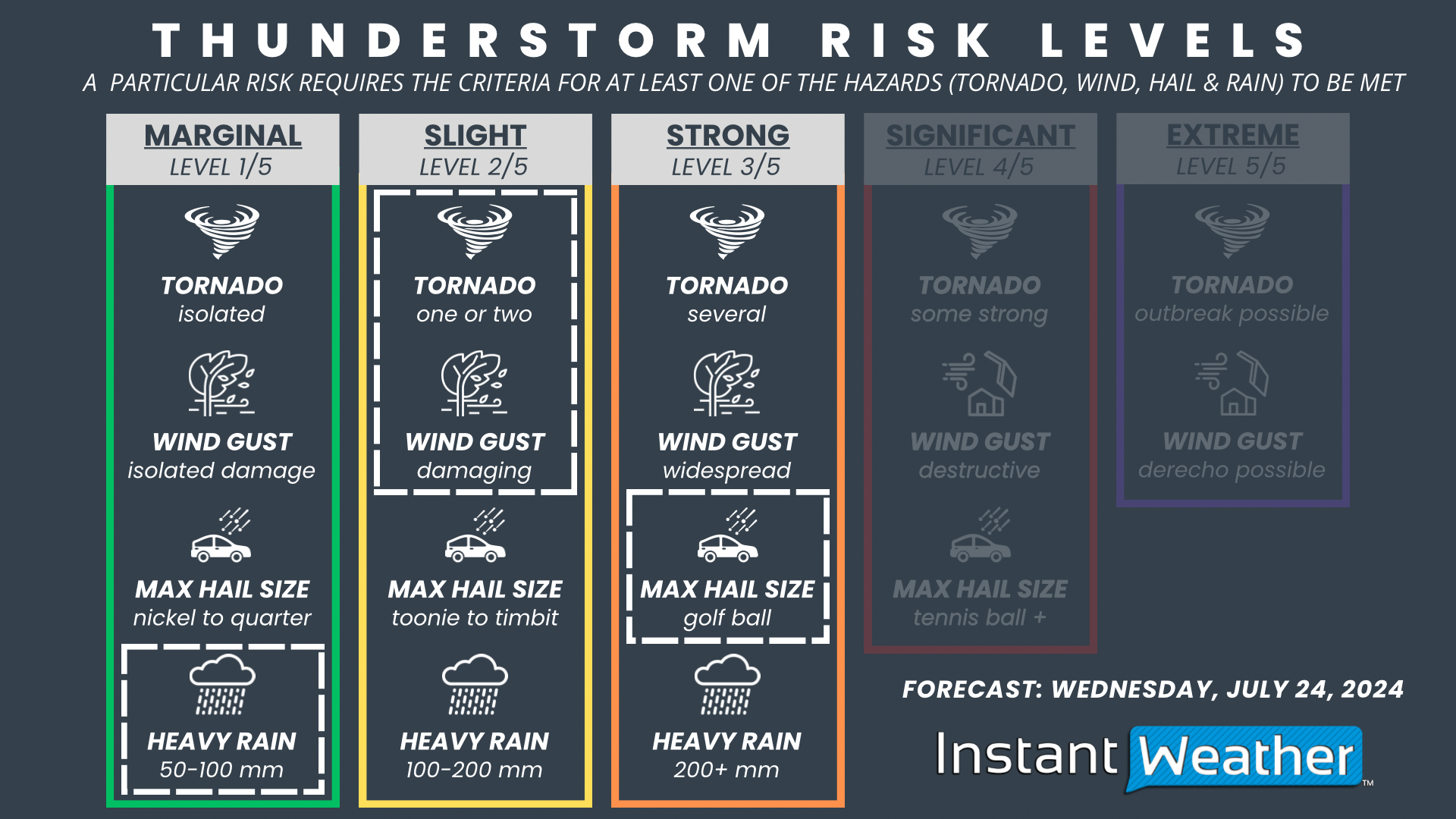
Currently, we’re going with a ‘slight’ (level 2/5) risk for severe storms in Southwestern Ontario on Friday. This is driven by the potential for fairly widespread damaging wind gusts. Hail up to the size of quarters and an isolated tornado risk are also possible hazards. We may need to introduce a more targeted ‘strong’ (level 3/5) risk zone in an updated forecast if confidence increases in where the storms will develop.

For those in Central Ontario and around the Golden Horseshoe, we’re assigning a ‘marginal’ (level 1/5) risk, mainly due to the potential for 90 km/h wind gusts later in the evening, along with flash flooding from multiple rounds of storms. While the tornado risk isn’t zero, it will be less of a concern by the time the storms reach these areas.


GOOGLE AD (NOT ENDORSED BY INSTANT WEATHER)

Summer’s Last Hurrah as Heat Returns to Southern Ontario & Conditional Strong Severe Threat on Tuesday

NOTE: YOU CAN CLICK ON THE MAP TO OPEN A ZOOMABLE IMAGE

Ready or not, the end of summer is rapidly approaching, with just one week left before students head back to school. Signs of autumn are already peeking through, with Environment Canada issuing a frost advisory last week in Northern Ontario, and of course, the arrival of pumpkin spice latte season!

However, it seems that Mother Nature has decided to give us one last taste of mid-summer weather. The start of this final week has brought steamy conditions, with warmer air making it feel like the 30s or even low 40s in some areas thanks to the humidex.

Along with the return of hot temperatures, we can expect some active weather, with multiple rounds of thunderstorms likely on Tuesday, possibly extending into Wednesday. While there is some uncertainty regarding the exact strength and timing of these storms, there is a risk that some could reach severe levels, bringing damaging wind gusts, large hail, and the potential for one or two tornadoes.


GOOGLE AD (NOT ENDORSED BY INSTANT WEATHER)

As mentioned, the dynamics of Tuesday’s storm risk remain highly conditional on timing. Some models suggest that decaying thunderstorm activity from Michigan could track into Southwestern and Central Ontario during the morning hours. If this occurs, it could deplete the atmospheric energy needed for storms later in the day when conditions are more favourable.

It's important to highlight that the potential for a "bust" in this event is moderately high, which is why we're focusing on the overall storm threat based on the environment, should storms develop.

The strongest conditions are expected along the southeastern shoreline of Lake Huron, extending into Deep Southwestern Ontario during the afternoon and evening hours. Storms could begin developing anytime between 12-1 PM and continue until sunset around 8 PM.


GOOGLE AD (NOT ENDORSED BY INSTANT WEATHER)

There is higher confidence in storm development further northeast around Lake Simcoe and into Central Ontario, though the environment isn't as strong in these areas. Multiple rounds of thunderstorms throughout the afternoon and early evening could impact the North Bay, Muskoka, Parry Sound, and Algonquin Park regions, with flash flooding being the primary concern.

In addition to the daytime storm risk, there are indications of a nocturnal storm risk around midnight, continuing into the pre-dawn hours of Wednesday. A strong line of storms could form over Michigan or Lake Huron and track across Southern Ontario. However, this will depend on earlier storms and how much energy remains in the atmosphere.


GOOGLE AD (NOT ENDORSED BY INSTANT WEATHER)

NOTE: YOU CAN CLICK ON THE MAP TO OPEN A ZOOMABLE IMAGE

Regarding expected storm hazards, we're assigning a 'strong' risk (level 3 out of 5) for parts of Southwestern Ontario, including Windsor, Chatham, Sarnia, Grand Bend, and London, based on the potential for widespread wind damage—again, this is conditional on storm development. Large hail up to the size of toonies and one or two tornadoes are also possible threats.

There is a widespread 'slight' risk for the rest of Southwestern Ontario and into Central Ontario. All storm hazards are possible, including strong wind gusts, large hail, and an isolated tornado. As mentioned, storms in Central Ontario could bring a flash flooding threat, with rainfall totals potentially reaching 100 to 150mm in the hardest-hit locations.


GOOGLE AD (NOT ENDORSED BY INSTANT WEATHER)

Further east, the Golden Horseshoe and a portion of Eastern Ontario are under a 'marginal' risk, where some storms later in the day or overnight could approach severe limits, primarily due to strong wind gusts and hail up to the size of quarters.

Wet & Unsettled Weekend Brings Threat of Severe Storms and Significant Rainfall to Southern Ontario

NOTE: YOU CAN CLICK ON THE MAP TO OPEN A ZOOMABLE IMAGE

As we approach the final weeks of summer, with the back-to-school season around the corner and the arrival of astronomical autumn just under a month away, it seems Mother Nature is continuing the trend of a wet summer. The upcoming weekend is set to bring multiple rounds of rainy weather, and by early next week, we might even get a taste of early fall-like conditions, with possible single-digit lows for parts of Southern Ontario.

Rain over the next few days will come in waves, starting Friday afternoon in Southwestern Ontario and lingering through the weekend. Thunderstorm activity will play a significant role in this weekend’s rainfall, potentially leading to localized totals approaching 80mm. The rain should taper off by early Monday, with Eastern Ontario seeing the last of the precipitation.


GOOGLE AD (NOT ENDORSED BY INSTANT WEATHER)

MODEL IMAGE FROM WEATHERBELL

As of Friday afternoon, the first wave of rain is already moving into Southwestern Ontario, extending into regions around Lake Huron and Georgian Bay. This cluster of rain and embedded thunderstorms is expected to gradually track eastward into the Golden Horseshoe and Central Ontario by Friday evening.

Rainfall amounts will be highly variable due to the thunderstorm component, but widespread totals of 5-15mm are expected by Saturday morning. Localized amounts could reach 25-50mm for areas that experience thunderstorm activity, though it’s difficult to pinpoint exactly where this will occur.


GOOGLE AD (NOT ENDORSED BY INSTANT WEATHER)

NOTE: YOU CAN CLICK ON THE MAP TO OPEN A ZOOMABLE IMAGE

Moving into Saturday, the rain will become less widespread, with a focus on Eastern Ontario and Southwestern Ontario during the morning hours. Eastern Ontario is expected to see lingering precipitation from Friday night’s first wave of rain.

We are also closely monitoring the risk of pop-up thunderstorms in Southwestern Ontario, extending into the Golden Horseshoe through late morning and early afternoon on Saturday. While these storms are expected to be mostly non-severe and primarily a rainfall risk, we can’t rule out a marginal severe threat, as the environment could potentially support some hazards, including hail and damaging wind gusts. An isolated tornado can’t be ruled out, though the risk is relatively low.


GOOGLE AD (NOT ENDORSED BY INSTANT WEATHER)

MODEL IMAGE FROM WEATHERBELL

More isolated pop-up thunderstorms are expected across Southwestern Ontario, the Golden Horseshoe, and Central Ontario throughout Saturday afternoon and evening. There is concern that these storms will be slow-moving, with some areas experiencing multiple rounds of storms in a short time frame. This could lead to a heightened flash flooding risk, particularly in more urban parts of Southern Ontario, such as the Greater Toronto Area.

Due to the localized nature of the rain on Saturday, some areas may not see a drop, while others could receive upwards of 50-75mm of rain. The heaviest rain appears to be concentrated along the Hwy 401 corridor between London and Toronto, with other pockets of heavy rain in Central Ontario. However, this is just a general idea from one model and could shift depending on where the storms develop.

There should be a break in the rainfall overnight Saturday for most areas, although a few localized showers are possible, particularly around Southwestern Ontario and the Golden Horseshoe.


GOOGLE AD (NOT ENDORSED BY INSTANT WEATHER)

MODEL IMAGE FROM WEATHERBELL

Similar to Saturday, pop-up thunderstorms are expected to return across Southern Ontario on Sunday morning and continue throughout the afternoon. These storms could bring additional heavy rainfall to the same regions affected by Saturday’s storms. Again, actual rainfall totals will vary significantly depending on where the storms hit, but some areas could see another 25-50mm (or more) by the end of Sunday.


NOTE: YOU CAN CLICK ON THE MAP TO OPEN A ZOOMABLE IMAGE

We are also closely monitoring the risk of severe storms in Eastern Ontario later in the afternoon and early evening on Sunday. Storms that develop here could bring damaging wind gusts, large hail, and potentially an isolated tornado. It’s still two days away, so much can change, but it appears that the Ottawa Valley, extending along the international border in Eastern Ontario, could see some marginally severe storms.


GOOGLE AD (NOT ENDORSED BY INSTANT WEATHER)

Rain is expected to continue overnight into Monday morning for Central and Eastern Ontario, with pockets of heavy rain and embedded thunderstorms. Southwestern Ontario and the Golden Horseshoe should finally see the rain taper off by late Sunday evening, with the rain ending in Eastern Ontario sometime Monday morning. This will give way to clear conditions for Monday afternoon and evening.

However, the calm weather will bring much colder air, with overnight temperatures plummeting into the single digits across much of Southern Ontario on Monday and Tuesday nights. Daytime highs will struggle to reach the 20°C mark on Tuesday and Wednesday, making for a much cooler week compared to what we’ve experienced this summer.

Debby to Bring Flooding Threat to Parts of Southern Ontario on Friday With Up to 50-100mm of Rain Possible

NOTE: YOU CAN CLICK ON THE MAP TO OPEN A ZOOMABLE IMAGE

After making landfall in Florida earlier this week, what was Tropical Storm Debby has brought significant rainfall along the US East Coast. Now a post-tropical system, Southern Ontario is on track to feel the effects of the remnants of Debby over the next few days.

Significant rainfall is in the forecast with a particular focus on Eastern Ontario, which could see up to 100mm by the end of the week. This is not what many across Southern Ontario will want to hear, considering this year's unusually wet summer.


GOOGLE AD (NOT ENDORSED BY INSTANT WEATHER)

There is still some uncertainty about the exact track of the system, as it won’t arrive until Friday. A more eastern track would shift the heavier rain across the border into the Northeastern US and Quebec.

On the other hand, if the system tracks further to the west, we could be talking about more widespread significant rainfall totals, potentially extending into Central Ontario and the Golden Horseshoe. Hence, it’s important to note that the forecast may change as we get closer to the arrival of the system.

MODEL IMAGE FROM WEATHERBELL

At this point, we are expecting to see some isolated pop-up showers and non-severe thunderstorms develop throughout the day on Thursday across Southern Ontario. This is in advance of the system on Friday, which is when we expect the bulk of the rainfall to occur.

Due to the localized nature of these storms, the rainfall totals will be extremely variable, ranging from a few millimetres to up to 15-20mm in the heaviest pockets by the end of Thursday.


MODEL IMAGE FROM WEATHERBELL

One thing we are closely monitoring is the potential for a persistent band of precipitation with embedded thunderstorms to develop late Thursday and carry into Friday. Current data suggests it will set up somewhere around Woodstock/Kitchener, stretching across Lake Simcoe and into Central Ontario.

This line could produce locally significant rainfall totals overnight and Friday morning as it essentially locks in place as the remnants of Debby approach from the southeast. Keep in mind that this line could shift and will be extremely localized, so not everyone will see the heavy rain. Local rainfall totals could approach 25-50mm by Friday morning, perhaps even higher if a particular area sees multiple rounds of thunderstorms.


GOOGLE AD (NOT ENDORSED BY INSTANT WEATHER)

The precipitation associated with the system is expected to spread across Eastern Ontario by Friday morning, which is when we expect to see the bulk of the forecasted rainfall. This will only heighten the flooding threat since it will all happen within the span of a few hours.

In addition to the rain, we are also likely to see some embedded thunderstorm activity within the bands of precipitation throughout the morning and afternoon on Friday.

These storms should stay mostly non-severe, but we’ve seen in the past that these tropical systems have a tendency to present a tornado threat, especially along the western side of the system, which is where Southern Ontario will be positioned.

This is certainly not a guarantee for tornadoes, but we will be closely watching this aspect of the system and will issue a more detailed forecast if it becomes more likely.


GOOGLE AD (NOT ENDORSED BY INSTANT WEATHER)

MODEL IMAGE FROM WEATHERBELL

Rain is expected to taper off in the west through Central Ontario into the Golden Horseshoe by early afternoon on Friday. For Eastern Ontario, heavy rain is expected to continue throughout the afternoon and early evening hours on Friday.

We should begin to see some clearing in the west by dinner time, with the rain finally coming to an end around midnight for the Ottawa Valley and those along the St. Lawrence.

As we’ve mentioned, the highest impact of this system is expected in Eastern Ontario, which will be closest to the track of the system. Rainfall totals are likely to generally range from 50-100mm, but some localized pockets could even exceed the 100mm mark based on some of the latest model data.

It is important to keep in mind that thunderstorm activity will play a big role in the rainfall totals, so the actual totals could vary significantly between locations. That’s why we have a large range of 50mm - it’s hard to nail down the exact totals due to the localized nature of thunderstorms.


GOOGLE AD (NOT ENDORSED BY INSTANT WEATHER)

The forecasted rainfall totals drop off quite fast once you head further west. We are projecting between 25 to 50mm of rain for the Golden Horseshoe and parts of Central Ontario around Lake Simcoe.

At this point, we are expecting 15-30mm of rain for the Greater Toronto Area (GTA) along the Lake Ontario shoreline into the Niagara region. That could change if that line of rain overnight Thursday shifts into the GTA, as the latest models suggest should develop just to the northwest.

Less than 20mm of rain is expected for Southwestern Ontario, with even lower totals for Deep Southwestern Ontario, which may see barely a drop of rain from this system.

Mid-Week Strong Severe Risk for Southern Ontario on Wednesday; Tornadoes Possible in the Ottawa Valley

NOTE: YOU CAN CLICK ON THE MAP TO OPEN A ZOOMABLE IMAGE

It has been a relatively quiet month for severe weather across Southern Ontario, aside from the significant rain that caused flash flooding in parts of the Greater Toronto Area last week. To put it into perspective, we have only seen two confirmed tornadoes this month, both occurring on July 10th in London.

However, the quiet period might be coming to an end with a potent storm threat for parts of Central and Eastern Ontario on Wednesday. All severe hazards are possible, including large hail, damaging wind gusts, and maybe even one or two tornadoes.


GOOGLE AD (NOT ENDORSED BY INSTANT WEATHER)

The storm threat will kick off quite early, with developing storms over Georgian Bay during the mid to late morning hours on Wednesday. Based on the latest models, these storms are likely to track into regions east of Georgian Bay, such as Parry Sound, Muskoka, and Simcoe County, between 10 AM and 1 PM. They could present some marginal severe threats, including strong wind gusts and hail up to the size of quarters. An isolated tornado can’t be ruled out.

By early afternoon, we expect these morning storms to begin merging into one main cluster of storms somewhere around Lake Simcoe. This cluster will be tracking into a more established environment through Bancroft and extending into the Ottawa Valley. As a result, the storm will likely intensify throughout the early to mid-afternoon hours.

There is some disagreement on the exact placement of this storm, but almost all models agree on the intensity. This is where we believe the tornado threat is the strongest.


GOOGLE AD (NOT ENDORSED BY INSTANT WEATHER)

Further storm development is possible to the southwest of the cluster, extending through Peterborough into parts of the Greater Toronto Area during the afternoon hours. These storms will gradually track to the east or northeast, although they could move quite slowly, leading to a potential flash flooding threat. Hail and strong wind gusts are also possible. An isolated tornado can’t be ruled out.

The storm risk will come to an end by early evening for those around Lake Simcoe and the Greater Toronto Area. For Eastern Ontario and the Ottawa Valley, expect the storms to fizzle out around 9 to 10 PM.


The focus of this severe risk will be on the Ottawa Valley, including Bancroft, Barry’s Bay, Smiths Falls, Renfrew, and the City of Ottawa. This is where we have a 'strong' (level 3) severe risk driven by the potential for large hail up to the size of golf balls. One or two tornadoes and damaging wind gusts are also possible with any storms that develop in this area.

The rest of Eastern Ontario, including Brockville, Kingston, Peterborough, and regions around Lake Simcoe, have a 'slight' (level 2) severe risk. Hail up to the size of toonies, damaging wind gusts, and heavy rainfall are possible threats. An isolated tornado is possible, but the strongest tornado risk should be contained to the Ottawa Valley.


GOOGLE AD (NOT ENDORSED BY INSTANT WEATHER)

For regions east of Georgian Bay into the Greater Toronto Area, there is a 'marginal' (level 1) severe risk. We don’t expect widespread severe weather here, but a few storms could bring isolated strong wind gusts and quarter-sized hail.

We will be closely following this threat and will post an updated forecast if there are any significant changes in the model data.

Early Morning Strong Severe Risk Followed by Widespread Threat Later in Day on Monday for Southern Ontario

NOTE: YOU CAN CLICK ON THE MAP TO OPEN A ZOOMABLE IMAGE

A complex weather situation is set to unfold across Southern Ontario over the next 24 hours as heat-fueled severe threats bring multiple rounds of storms on Monday.

We are already seeing the formation of what will be the first round of storms, expected to track into Southwestern Ontario early Monday morning. A cluster of intense storms began taking shape over Wisconsin and Illinois late Sunday evening. The Chicago area took a direct hit, prompting a tornado warning to be issued with multiple visible areas of rotation on radar over the city.


GOOGLE AD (NOT ENDORSED BY INSTANT WEATHER)

The environment is building ahead of the storms, and models agree that it will maintain its strength through the overnight hours as it tracks eastward through Michigan. Based on this, we feel that the Windsor and Chatham areas could face a strong risk of severe weather starting around 4-5 a.m. on Monday. The exact arrival of this storm and its strength remain somewhat uncertain.

The main concern is the potential for destructive wind gusts exceeding 100 km/h. As seen in Chicago, brief spin-ups aren’t out of the question, so an isolated tornado threat could also be present. The hail risk will be lower, likely maxing out at around nickel to quarter-sized hail.

The first round of storms will come to an end by the late morning hours as the decaying line of storms moves out over Lake Erie and south of the border. However, this won’t be the end of the risk for Monday. Additional storms could follow in the wake of that main line through Southwestern Ontario around the noon hour.


GOOGLE AD (NOT ENDORSED BY INSTANT WEATHER)

A more widespread threat of severe weather is expected to develop during the early afternoon hours in the Niagara region and to the northeast of Lake Simcoe. All severe hazards could be on the table, including hail up to the size of toonies, damaging wind gusts, and an isolated tornado.

Starting with the Niagara region, the latest model data shows the development of a cluster of strong storms somewhere around London and Brantford during the early afternoon. The environment is favourable for this cluster to become severe as it tracks along the Lake Erie shoreline into the Niagara region and crosses the border into New York by the mid to late afternoon.

Further north, storms are likely to bubble up along a corridor stretching from Lake Simcoe through Bancroft and into the Ottawa Valley starting around 2 to 4 p.m. and continuing into the early evening hours. This activity is expected to be fairly isolated, and not everyone will see a storm, but the potential is there for anywhere in Central and Eastern Ontario.


GOOGLE AD (NOT ENDORSED BY INSTANT WEATHER)

We have opted for a ‘strong’ (level 3 out of 5) severe risk for Deep Southwestern Ontario, including Windsor and Chatham. This is driven by the destructive wind gust threat early Monday morning with the expected line of storms around 4 to 6 a.m.

Outside of the strong risk, we have a ‘slight’ (level 2) severe risk for the Niagara region along with parts of Central and Eastern Ontario. A few storms could reach the severe threshold with toonie-sized hail, damaging wind gusts, and an isolated tornado.

The rest of Southern Ontario is in the ‘marginal’ (level 1) severe risk, as it can’t be ruled out that any storms that pop up could present some severe hazards. It’s important to note that it’s hard to pinpoint where these storms will appear, so you are not guaranteed a storm even if you are in a risk zone on our map.


GOOGLE AD (NOT ENDORSED BY INSTANT WEATHER)

We have our eyes on Tuesday, which could see a fairly strong risk of severe storms during the afternoon and evening hours. At this point, Central and Eastern Ontario appear to be in the bullseye for a second day, with the threat likely ranging from a ‘slight’ (level 2) to a ‘strong’ (level 3) risk. This could also extend into parts of the Golden Horseshoe. A more detailed forecast for Tuesday will be issued by late Monday.

Isolated Severe Threat to Cap Off the Weekend for Parts of Southern Ontario on Sunday

NOTE: YOU CAN CLICK ON THE MAP TO OPEN A ZOOMABLE IMAGE

Many across Southern Ontario enjoyed a beautiful start to the weekend on Saturday, with temperatures soaring into the upper 20s and even low 30s. This prompted Environment Canada to issue heat warnings in some parts of Southern and Northern Ontario, as this prolonged period of hot weather is expected to continue into the upcoming week.

As is typical, the hot temperatures are expected to fuel several rounds of potential severe weather over the next few days. This will begin on Sunday with an isolated severe risk for parts of Southwestern and Central Ontario, along with the Greater Toronto Area.


GOOGLE AD (NOT ENDORSED BY INSTANT WEATHER)

Current data suggests that there could be two separate rounds of storms on Sunday. The first round could lead to a noisy wake-up call during the morning hours as a decaying line of storms crosses over Lake Huron into Southwestern Ontario from Michigan.

We expect that the line will reach our region sometime between 8 and 10 a.m. However, there is some disagreement among the models on how strong this line will be by the time it crosses the border.

If it doesn’t fizzle out before reaching our region, it could feature marginally severe wind gusts ranging from 90 to 100 km/h along the Lake Huron shoreline and into Deep Southwestern Ontario. The tornado threat is fairly low due to the timing and storm mode, but as always, it can’t be fully ruled out.


GOOGLE AD (NOT ENDORSED BY INSTANT WEATHER)

This first round will be critical in setting the stage for the second round of storms later in the day during the afternoon. If the morning storms take longer than expected to clear out and linger into the early afternoon, this may prevent the daylight heating needed for further storm development.

Provided that the morning storms move out in a timely fashion, we expect isolated storms to pop up anywhere from Lake Huron extending to the northeast into areas around Lake Simcoe and parts of Central Ontario. This could begin as early as 2-3 p.m. with storm development possible through the early evening hours.


Due to the lower confidence in storm development, we are currently forecasting a marginal (level 1) severe risk. Any storms that do develop could present all severe hazards, including damaging wind gusts, large hail up to the size of quarters, and maybe even an isolated tornado.

We may need to consider an upgrade to a slight (level 2) risk in an updated forecast once we see how fast the morning storms clear out and allow for further daylight heating.

The storm threat will come to an end by the late evening hours on Sunday once the sun goes down. We are closely watching the potential for more storms on Monday; however, at this point, the threat is looking extremely isolated with limited storm development. Tuesday is looking a lot more active in terms of storms.